 |
|
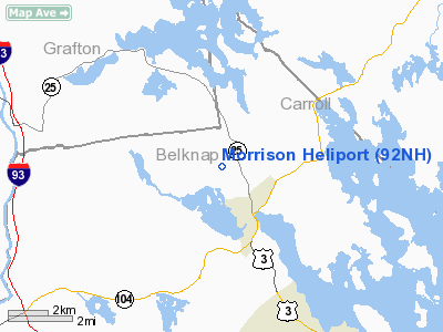
Location & QuickFacts
| FAA Information Effective: | 2008-09-25 |
| Airport Identifier: | 92NH |
| Airport Status: | Operational |
| Longitude/Latitude: | 071-31-10.0000W/43-40-46.0000N
-71.519444/43.679444 (Estimated) |
| Elevation: | 720 ft / 219.46 m (Estimated) |
| Land: | 0 acres |
| From nearest city: | 2 nautical miles S of Meredith, NH |
| Location: | Belknap County, NH |
| Magnetic Variation: | () |
Owner & Manager
| Ownership: | Privately owned |
| Owner: | Alfred R. Morrison |
| Address: | 92 Bartlett Hill Road
Center Harbor, NH 03226 |
| Phone number: | 781-864-5000 |
| Manager: | Alfred R. Morrison |
| Address: | 92 Barlett Hill Road
Center Harbor, NH 03226 |
| Phone number: | 781-864-5000 |
Airport Operations and Facilities
| Airport Use: | Private |
| Control Tower: | No |
| Sectional chart: | Montreal |
| Region: | ANE - New England |
| Boundary ARTCC: | ZBW - Boston |
| Tie-in FSS: | BGR - Bangor |
| FSS Toll Free: | 1-800-WX-BRIEF |
Runway Information
Helipad H1
| Dimension: | 400 x 125 ft / 121.9 x 38.1 m |
| Surface: | TURF-GRVL, |
| |
Runway H1 |
Runway |
| Traffic Pattern: | Left | Left |
|
Radio Navigation Aids
| ID |
Type |
Name |
Ch |
Freq |
Var |
Dist |
| LCI | FAN MARKER | Laconia | | | | 7.6 nm |
| SZO | FAN MARKER | Grinn | | | 17W | 32.3 nm |
| HIE | FAN MARKER | Witey | | | 17W | 41.4 nm |
| LC | NDB | Blnap | | 328.00 | 16W | 8.6 nm |
| LAH | NDB | Hanover | | 276.00 | 15W | 28.6 nm |
| CO | NDB | Epsom | | 216.00 | 16W | 33.8 nm |
| SZO | NDB | Sebago | | 227.00 | 17W | 34.7 nm |
| ESG | NDB | Rollins | | 260.00 | 16W | 40.9 nm |
| CNH | NDB | Claremont | | 233.00 | 16W | 41.5 nm |
| GMA | NDB | Mahn | | 386.00 | 17W | 41.7 nm |
| IVV | NDB | White River | | 379.00 | 16W | 41.8 nm |
| DRY | NDB | Derry | | 338.00 | 16W | 49.0 nm |
| LEB | VOR/DME | Lebanon | 084X | 113.70 | 15W | 30.3 nm |
| PSM | VOR/DME | Pease | 112X | 116.50 | 16W | 46.7 nm |
| MPV | VOR/DME | Montpelier | 045X | 110.80 | 16W | 47.1 nm |
| MHT | VOR/DME | Manchester | 091X | 114.40 | 15W | 49.2 nm |
| CON | VORTAC | Concord | 076X | 112.90 | 15W | 27.7 nm |
| ENE | VORTAC | Kennebunk | 118X | 117.10 | 17W | 42.3 nm |
Remarks
- PRVDD VFR OPNS, PR USE, WIND INDICATOR IS MAINTAINED, DAYTIME USE ONLY & AREA IS MKD.
Images and information placed above are from
http://www.airport-data.com/airport/92NH/
We thank them for the data!
|
|


