 |
|
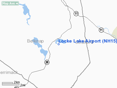
Location & QuickFacts
| FAA Information Effective: | 2008-09-25 |
| Airport Identifier: | NH15 |
| Airport Status: | Operational |
| Longitude/Latitude: | 071-14-00.2390W/43-23-12.2880N
-71.233400/43.386747 (Estimated) |
| Elevation: | 702 ft / 213.97 m (Estimated) |
| Land: | 44 acres |
| From nearest city: | 4 nautical miles NE of Barnstead, NH |
| Location: | Belknap County, NH |
| Magnetic Variation: | 16W (1985) |
Owner & Manager
| Ownership: | Privately owned |
| Owner: | Kent D. Locke Sr. |
| Address: | N Barnstead Rd
Barnstead, NH 93225 |
| Manager: | Arthur Roy Vick |
| Address: | 7 Crest Ridge Dr Po Box 150
Center Barnstead, NH 03225 |
| Phone number: | 603-269-7531 |
Airport Operations and Facilities
| Airport Use: | Private |
| Wind indicator: | Yes |
| Segmented Circle: | No |
| Control Tower: | No |
| Landing fee charge: | No |
| Sectional chart: | New York |
| Region: | ANE - New England |
| Boundary ARTCC: | ZBW - Boston |
| Tie-in FSS: | BGR - Bangor |
| FSS on Airport: | No |
| FSS Toll Free: | 1-800-WX-BRIEF |
Airport Services
| Airframe Repair: | NONE |
| Power Plant Repair: | NONE |
Runway Information
Runway 15/33
| Dimension: | 2500 x 300 ft / 762.0 x 91.4 m |
| Surface: | TURF, |
| |
Runway 15 |
Runway 33 |
| Traffic Pattern: | Left | Left |
|
Radio Navigation Aids
| ID |
Type |
Name |
Ch |
Freq |
Var |
Dist |
| LCI | FAN MARKER | Laconia | | | | 14.1 nm |
| SZO | FAN MARKER | Grinn | | | 17W | 37.5 nm |
| BVY | FAN MARKER | Beverly | | | | 48.4 nm |
| LC | NDB | Blnap | | 328.00 | 16W | 16.0 nm |
| CO | NDB | Epsom | | 216.00 | 16W | 18.7 nm |
| ESG | NDB | Rollins | | 260.00 | 16W | 20.4 nm |
| DRY | NDB | Derry | | 338.00 | 16W | 31.9 nm |
| SZO | NDB | Sebago | | 227.00 | 17W | 36.8 nm |
| AS | NDB | Chern | | 359.00 | 16W | 37.5 nm |
| LAH | NDB | Hanover | | 276.00 | 15W | 45.3 nm |
| TOF | NDB | Topsfield | | 269.00 | 16W | 47.7 nm |
| CNH | NDB | Claremont | | 233.00 | 16W | 49.7 nm |
| PSM | VOR/DME | Pease | 112X | 116.50 | 16W | 25.3 nm |
| MHT | VOR/DME | Manchester | 091X | 114.40 | 15W | 31.7 nm |
| LWM | VOR/DME | Lawrence | 072X | 112.50 | 15W | 39.3 nm |
| LEB | VOR/DME | Lebanon | 084X | 113.70 | 15W | 46.3 nm |
| CON | VORTAC | Concord | 076X | 112.90 | 15W | 18.0 nm |
| ENE | VORTAC | Kennebunk | 118X | 117.10 | 17W | 27.2 nm |
| PWM | VOT | Portland Intl Jetport | | 111.00 | | 42.8 nm |
Remarks
- 3000' BETWEEN TALL TREES.
- VFR ONLY, PERSONAL USE.
Images and information placed above are from
http://www.airport-data.com/airport/NH15/
We thank them for the data!
| General Info
|
| Country |
United States
|
| State |
NEW HAMPSHIRE
|
| FAA ID |
NH15
|
| Latitude |
43-23-12.288N
|
| Longitude |
071-14-00.239W
|
| Elevation |
702 feet
|
| Near City |
BARNSTEAD
|
We don't guarantee the information is fresh and accurate. The data may
be wrong or outdated.
For more up-to-date information please refer to other sources.
|
|


