 |
|
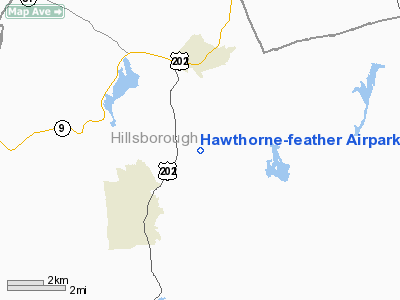
Hawthorne-feather Airpark Airport |
Location & QuickFacts
| FAA Information Effective: | 2008-09-25 |
| Airport Identifier: | 8B1 |
| Airport Status: | Operational |
| Longitude/Latitude: | 071-53-58.2860W/43-04-00.2890N
-71.899524/43.066747 (Estimated) |
| Elevation: | 600 ft / 182.88 m (Estimated) |
| Land: | 50 acres |
| From nearest city: | 3 nautical miles S of Hillsboro, NH |
| Location: | Hillsborough County, NH |
| Magnetic Variation: | 16W (1985) |
Owner & Manager
| Ownership: | Privately owned |
| Owner: | James T. Rymes |
| Address: | 2 Main St
Antrim, NH 03440 |
| Phone number: | 603-588-6868 |
| Manager: | James T. Rymes |
| Address: | 2 Main St
Antrim, NH 03440 |
| Phone number: | 603-588-6868 |
Airport Operations and Facilities
| Airport Use: | Open to public |
| Wind indicator: | Yes |
| Segmented Circle: | No |
| Control Tower: | No |
| Lighting Schedule: | RDO-CTL
ACTVT ROTATING BEACON, MIRL RY 02/20 - CTAF. |
| Beacon Color: | Clear-Green (lighted land airport) |
| Landing fee charge: | No |
| Sectional chart: | New York |
| Region: | ANE - New England |
| Boundary ARTCC: | ZBW - Boston |
| Tie-in FSS: | BGR - Bangor |
| FSS on Airport: | No |
| FSS Toll Free: | 1-800-WX-BRIEF |
| NOTAMs Facility: | BGR (NOTAM-d service avaliable) |
Airport Communications
| CTAF: | 122.800 |
| Unicom: | 122.800 |
Airport Services
| Fuel available: | 100LL
SELF SERV FUEL AVBL 24 HRS BY CREDIT CARD SYSTEM. |
| Bottled Oxygen: | NONE |
| Bulk Oxygen: | NONE |
Runway Information
Runway 02/20
| Dimension: | 3260 x 75 ft / 993.6 x 22.9 m |
| Surface: | ASPH, Fair Condition |
| Weight Limit: | Single wheel: 8000 lbs. |
| Edge Lights: | Medium |
| |
Runway 02 |
Runway 20 |
| Traffic Pattern: | Left | Right |
| Markings: | Basic, Fair Condition
MARKINGS FADED. | Basic, Fair Condition |
| Runway End Identifier: | | No |
| Centerline Lights: | No | No |
| Touchdown Lights: | No | No |
| Obstruction: | 50 ft trees, 200.0 ft from runway, 80 ft left of centerline
RY 02 HAS +50 FT TREES AT THLD 80 FT L. | 50 ft trees, 200.0 ft from runway, 90 ft right of centerline
RY 20 HAS +50 TREES AT THLD 90 FT R. |
|
Radio Navigation Aids
| ID |
Type |
Name |
Ch |
Freq |
Var |
Dist |
| LCI | FAN MARKER | Laconia | | | | 36.1 nm |
| AS | NDB | Chern | | 359.00 | 16W | 19.6 nm |
| CO | NDB | Epsom | | 216.00 | 16W | 19.9 nm |
| DRY | NDB | Derry | | 338.00 | 16W | 25.1 nm |
| CNH | NDB | Claremont | | 233.00 | 16W | 27.5 nm |
| FIT | NDB | Fitchburg | | 365.00 | 15W | 31.6 nm |
| LC | NDB | Blnap | | 328.00 | 16W | 32.4 nm |
| SXD | NDB | Springfield | | 265.00 | 15W | 32.5 nm |
| ORE | NDB | Orange | | 205.00 | 15W | 34.5 nm |
| IVV | NDB | White River | | 379.00 | 16W | 38.6 nm |
| LAH | NDB | Hanover | | 276.00 | 15W | 40.1 nm |
| VWD | NDB | Mount Snow | | 224.00 | 15W | 43.2 nm |
| ESG | NDB | Rollins | | 260.00 | 16W | 47.9 nm |
| SKR | NDB | Shaker Hill | | 251.00 | 16W | 48.6 nm |
| TOF | NDB | Topsfield | | 269.00 | 16W | 49.5 nm |
| MHT | VOR/DME | Manchester | 091X | 114.40 | 15W | 26.2 nm |
| LEB | VOR/DME | Lebanon | 084X | 113.70 | 15W | 39.3 nm |
| LWM | VOR/DME | Lawrence | 072X | 112.50 | 15W | 40.5 nm |
| PSM | VOR/DME | Pease | 112X | 116.50 | 16W | 46.9 nm |
| CON | VORTAC | Concord | 076X | 112.90 | 15W | 16.9 nm |
| EEN | VORTAC | Keene | 031X | 109.40 | 14W | 23.8 nm |
| GDM | VORTAC | Gardner | 043X | 110.60 | 14W | 32.1 nm |
| BED | VOT | Laurence G Hanscom Fld | | 110.00 | | 45.0 nm |
| ORH | VOT | Worcester | | 108.20 | | 48.1 nm |
Remarks
- HOUSE N END.
- PRIOR TO USING ARPT CALL 603-588-6868 FOR ARPT CONDS.
- VFR OPNS ONLY.
Images and information placed above are from
http://www.airport-data.com/airport/8B1/
We thank them for the data!
| General Info
|
| Country |
United States
|
| State |
NEW HAMPSHIRE
|
| FAA ID |
8B1
|
| Latitude |
43-04-00.289N
|
| Longitude |
071-53-58.286W
|
| Elevation |
600 feet
|
| Near City |
HILLSBORO
|
We don't guarantee the information is fresh and accurate. The data may
be wrong or outdated.
For more up-to-date information please refer to other sources.
|
|


