 |
|
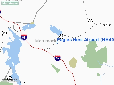
Location & QuickFacts
| FAA Information Effective: | 2008-09-25 |
| Airport Identifier: | NH40 |
| Airport Status: | Operational |
| Longitude/Latitude: | 071-57-01.2980W/43-24-16.7700N
-71.950361/43.404658 (Estimated) |
| Elevation: | 998 ft / 304.19 m (Estimated) |
| Land: | 11 acres |
| From nearest city: | 2 nautical miles ES of New London, NH |
| Location: | Merrimack County, NH |
| Magnetic Variation: | 16W (1985) |
Owner & Manager
| Ownership: | Privately owned |
| Owner: | Lake Sunapee C C Dev Corp |
| Address: | Rr 2 Box 735
New London, NH 03257 |
| Phone number: | 603-526-6040 |
| Manager: | Douglas J Homan |
| Address: | P O Box 2460
New London, NH 03257 |
| Phone number: | 603-526-6040 |
Airport Operations and Facilities
| Airport Use: | Private |
| Segmented Circle: | No |
| Control Tower: | No |
| Landing fee charge: | No |
| Sectional chart: | New York |
| Region: | ANE - New England |
| Boundary ARTCC: | ZBW - Boston |
| Tie-in FSS: | BGR - Bangor |
| FSS on Airport: | No |
| FSS Toll Free: | 1-800-WX-BRIEF |
Airport Communications
Runway Information
Runway 14/32
| Dimension: | 2800 x 30 ft / 853.4 x 9.1 m |
| Surface: | ASPH, Good Condition |
| |
Runway 14 |
Runway 32 |
| Traffic Pattern: | Left | Left |
|
Radio Navigation Aids
| ID |
Type |
Name |
Ch |
Freq |
Var |
Dist |
| LCI | FAN MARKER | Laconia | | | | 24.3 nm |
| R | FAN MARKER | Chitt | | | 14W | 46.8 nm |
| CNH | NDB | Claremont | | 233.00 | 16W | 18.5 nm |
| LC | NDB | Blnap | | 328.00 | 16W | 19.7 nm |
| LAH | NDB | Hanover | | 276.00 | 15W | 20.4 nm |
| IVV | NDB | White River | | 379.00 | 16W | 24.3 nm |
| CO | NDB | Epsom | | 216.00 | 16W | 27.8 nm |
| SXD | NDB | Springfield | | 265.00 | 15W | 29.0 nm |
| AS | NDB | Chern | | 359.00 | 16W | 38.1 nm |
| DRY | NDB | Derry | | 338.00 | 16W | 40.3 nm |
| DYO | NDB | Smuto | | 221.00 | 15W | 47.5 nm |
| VWD | NDB | Mount Snow | | 224.00 | 15W | 49.3 nm |
| LEB | VOR/DME | Lebanon | 084X | 113.70 | 15W | 20.1 nm |
| MHT | VOR/DME | Manchester | 091X | 114.40 | 15W | 41.1 nm |
| RUT | VOR/DME | Rutland | 47X | 111.00 | 15W | 44.3 nm |
| MPV | VOR/DME | Montpelier | 045X | 110.80 | 16W | 46.3 nm |
| CON | VORTAC | Concord | 076X | 112.90 | 15W | 19.8 nm |
| EEN | VORTAC | Keene | 031X | 109.40 | 14W | 39.6 nm |
Remarks
- DO NOT CHART.
- VFR USE ONLY.
Images and information placed above are from
http://www.airport-data.com/airport/NH40/
We thank them for the data!
| General Info
|
| Country |
United States
|
| State |
NEW HAMPSHIRE
|
| FAA ID |
NH40
|
| Latitude |
43-24-16.770N
|
| Longitude |
071-57-01.298W
|
| Elevation |
998 feet
|
| Near City |
NEW LONDON
|
We don't guarantee the information is fresh and accurate. The data may
be wrong or outdated.
For more up-to-date information please refer to other sources.
|
|


