 |
|
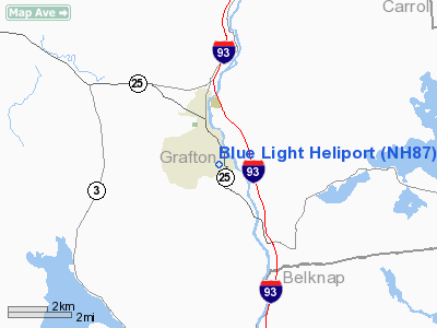
Location & QuickFacts
| FAA Information Effective: | 2008-09-25 |
| Airport Identifier: | NH87 |
| Airport Status: | Operational |
| Longitude/Latitude: | 071-40-44.7400W/43-44-02.1400N
-71.679094/43.733928 (Estimated) |
| Elevation: | 825 ft / 251.46 m (Estimated) |
| Land: | 0 acres |
| From nearest city: | 2 nautical miles S of Plymouth, NH |
| Location: | Grafton County, NH |
| Magnetic Variation: | 16W (2000) |
Owner & Manager
| Ownership: | Privately owned |
| Owner: | Frank A. Miller |
| Address: | P.o. Box 456
Plymouth, NH 03264-0456 |
| Phone number: | 603-536-7543 |
| Manager: | Frank A. Miller |
| Address: | P.o. Box 456
Plymouth, NH 03264-0456 |
| Phone number: | 603-536-7543 |
Airport Operations and Facilities
| Airport Use: | Private |
| Wind indicator: | Yes |
| Segmented Circle: | No |
| Control Tower: | No |
| Sectional chart: | New York |
| Region: | ANE - New England |
| Boundary ARTCC: | ZBW - Boston |
| Tie-in FSS: | BGR - Bangor |
| FSS Toll Free: | 1-800-WX-BRIEF |
Runway Information
Helipad H1
| Dimension: | 25 x 25 ft / 7.6 x 7.6 m |
| Surface: | CONC, |
| |
Runway H1 |
Runway |
| Traffic Pattern: | Left | Left |
|
Radio Navigation Aids
| ID |
Type |
Name |
Ch |
Freq |
Var |
Dist |
| LCI | FAN MARKER | Laconia | | | | 14.4 nm |
| SZO | FAN MARKER | Grinn | | | 17W | 37.1 nm |
| HIE | FAN MARKER | Witey | | | 17W | 38.4 nm |
| LC | NDB | Blnap | | 328.00 | 16W | 13.4 nm |
| LAH | NDB | Hanover | | 276.00 | 15W | 21.7 nm |
| IVV | NDB | White River | | 379.00 | 16W | 35.8 nm |
| CNH | NDB | Claremont | | 233.00 | 16W | 37.3 nm |
| GMA | NDB | Mahn | | 386.00 | 17W | 37.8 nm |
| CO | NDB | Epsom | | 216.00 | 16W | 38.3 nm |
| SZO | NDB | Sebago | | 227.00 | 17W | 40.2 nm |
| ESG | NDB | Rollins | | 260.00 | 16W | 48.3 nm |
| SXD | NDB | Springfield | | 265.00 | 15W | 48.4 nm |
| LLX | NDB | Lyndonville | | 353.00 | 16W | 48.7 nm |
| LEB | VOR/DME | Lebanon | 084X | 113.70 | 15W | 23.6 nm |
| MPV | VOR/DME | Montpelier | 045X | 110.80 | 16W | 39.5 nm |
| CON | VORTAC | Concord | 076X | 112.90 | 15W | 31.2 nm |
| ENE | VORTAC | Kennebunk | 118X | 117.10 | 17W | 50.0 nm |
Remarks
- PRVDD VFR OPNS & ALL USERS COMPLY WITH THIS CONDITION; RECOMMEND DAYLIGHT USE ONLY & INGRESS & EGRESS FM NORTH, NORTHEAST, EAST, SOUTHEAST & SOUTH.
Images and information placed above are from
http://www.airport-data.com/airport/NH87/
We thank them for the data!
| General Info
|
| Country |
United States
|
| State |
NEW HAMPSHIRE
|
| FAA ID |
NH87
|
| Latitude |
43-44-02.140N
|
| Longitude |
071-40-44.740W
|
| Elevation |
825 feet
|
| Near City |
PLYMOUTH
|
We don't guarantee the information is fresh and accurate. The data may
be wrong or outdated.
For more up-to-date information please refer to other sources.
|
|


