 |
|
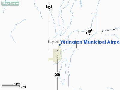
| Yerington Municipal Airport |
| IATA: none – ICAO: none – FAA LID: O43 |
| Summary |
| Operator |
City of Yerington |
| Serves |
Yerington, Nevada |
| Elevation AMSL |
4,378 ft / 1,334.4 m |
| Coordinates |
39°00′15″N 119°09′29″W / 39.00417°N 119.15806°W / 39.00417; -119.15806Coordinates: 39°00′15″N 119°09′29″W / 39.00417°N 119.15806°W / 39.00417; -119.15806 |
| Runways |
| Direction |
Length |
Surface |
| ft |
m |
| 1/19 |
5,800 |
1,768 |
Asphalt |
Yerington Municipal Airport (FAA LID: O43) is a public airport located one mile (2 km) north of the central business district (CBD) of Yerington, a city in Lyon County, Nevada, USA.
Facilities
Yerington Municipal Airport covers 101 acres (41 ha) and has one runway:
- Runway 1/19: 5,800 x 75 ft. (1,768 x 23 m), Surface: Asphalt
The above content comes from Wikipedia and is published under free licenses – click here to read more.
Location & QuickFacts
| FAA Information Effective: | 2008-09-25 |
| Airport Identifier: | O43 |
| Airport Status: | Operational |
| Longitude/Latitude: | 119-09-28.5490W/39-00-14.7040N
-119.157930/39.004084 (Estimated) |
| Elevation: | 4378 ft / 1334.41 m (Surveyed) |
| Land: | 101 acres |
| From nearest city: | 1 nautical miles N of Yerington, NV |
| Location: | Lyon County, NV |
| Magnetic Variation: | 16E (1985) |
Owner & Manager
| Ownership: | Publicly owned |
| Owner: | City Of Yerington |
| Address: | 102 S. Main St.
Yerington, NV 89447 |
| Phone number: | 775-463-3511 |
| Manager: | Dan Newell |
| Address: | 102 S. Main St.
Yerington, NV 89447 |
| Phone number: | 775-463-3511 |
Airport Operations and Facilities
| Airport Use: | Open to public |
| Wind indicator: | Yes |
| Segmented Circle: | Yes |
| Control Tower: | No |
| Lighting Schedule: | DUSK-DAWN
ACTVT MIRL RY 01/19 - CTAF. |
| Beacon Color: | Clear-Green (lighted land airport) |
| Landing fee charge: | No |
| Sectional chart: | San Francisco |
| Region: | AWP - Western-Pacific |
| Traffic Pattern Alt: | 800 ft |
| Boundary ARTCC: | ZOA - Oakland |
| Tie-in FSS: | RNO - Reno |
| FSS on Airport: | No |
| FSS Toll Free: | 1-800-WX-BRIEF |
| NOTAMs Facility: | RNO (NOTAM-d service avaliable) |
| Federal Agreements: | NGY |
Airport Communications
| CTAF: | 122.800 |
| Unicom: | 122.800 |
Airport Services
| Fuel available: | 100LL |
| Airframe Repair: | MAJOR |
| Power Plant Repair: | MAJOR |
| Bottled Oxygen: | NONE |
| Bulk Oxygen: | NONE |
Runway Information
Runway 01/19
| Dimension: | 5800 x 75 ft / 1767.8 x 22.9 m |
| Surface: | ASPH, Fair Condition |
| Weight Limit: | Single wheel: 24000 lbs.
Dual wheel: 32000 lbs. |
| Edge Lights: | Medium |
| |
Runway 01 |
Runway 19 |
| Traffic Pattern: | Left | Left |
| Markings: | Basic, Poor Condition
RWY 01/19 MARKINGS FADED | Basic, Poor Condition
RWY 19 MARKINGS FADED |
| Crossing Height: | 40.00 ft | 40.00 ft |
| VASI: | 2-light PAPI on left side | 2-light PAPI on left side |
| Visual Glide Angle: | 3.00° | 3.00° |
| Runway End Identifier: | No | Yes
REIL OTS INDEFLY. |
| Centerline Lights: | No | No |
| Touchdown Lights: | No | No |
| Obstruction: | , 50:1 slope to clear | 80 ft trees, 1785.0 ft from runway, 52 ft left of centerline, 19:1 slope to clear |
|
Radio Navigation Aids
| ID |
Type |
Name |
Ch |
Freq |
Var |
Dist |
| NFL | TACAN | Fallon | 082X | | 16E | 32.6 nm |
| HZN | VORTAC | Hazen | 088X | 114.10 | 17E | 31.7 nm |
| FMG | VORTAC | Mustang | 126X | 117.90 | 16E | 39.3 nm |
Images and information placed above are from
http://www.airport-data.com/airport/O43/
We thank them for the data!
| General Info
|
| Country |
United States
|
| State |
NEVADA
|
| FAA ID |
O43
|
| Latitude |
39-00-14.704N
|
| Longitude |
119-09-28.549W
|
| Elevation |
4378 feet
|
| Near City |
YERINGTON
|
We don't guarantee the information is fresh and accurate. The data may
be wrong or outdated.
For more up-to-date information please refer to other sources.
|
|


