|
|
| Winnemucca Municipal Airport |
 |
| IATA: WMC – ICAO: KWMC – FAA LID: WMC |
| Summary |
| Airport type |
City/County of Winnemucca |
| Operator |
Winnemucca, Nevada |
| Location |
4,308 |
| Elevation AMSL |
1,313.1 ft / m |
| Coordinates |
40°53′48″N 117°48′21″W / 40.89667°N 117.80583°W / 40.89667; -117.80583Coordinates: 40°53′48″N 117°48′21″W / 40.89667°N 117.80583°W / 40.89667; -117.80583 |
| Runways |
| Direction |
Length |
Surface |
| ft |
m |
| 14/32 |
7,000 |
2,134 |
Asphalt |
| 2/20 |
4,800 |
1,463 |
Asphalt |
| Helipads |
| Number |
Length |
Surface |
| ft |
m |
| H1 |
25 |
8 |
Concrete |
| H2 |
25 |
8 |
Concrete |
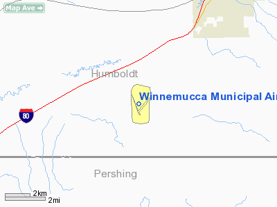
Winnemucca Municipal Airport (IATA: WMC, ICAO: KWMC, FAA LID: WMC) is a public airport located five miles (8 km) southwest of the central business district of Winnemucca, in Humboldt County, Nevada, United States.
Facilities
Winnemucca Municipal Airport covers 968 acres (392 ha) and has two runways and two helipads:
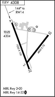
- Runway 14/32: 7,000 x 100 ft. (2,134 x 30 m), Surface: Asphalt
- Runway 2/20: 4,800 x 75 ft. (1,463 x 23 m), Surface: Asphalt
- Helipad H1: 25 x 25 ft. (8 x 8 m), Surface: Concrete
- Helipad H2: 25 x 25 ft. (8 x 8 m), Surface: Concrete
The above content comes from Wikipedia and is published under free licenses – click here to read more.
Location & QuickFacts
| FAA Information Effective: | 2008-09-25 |
| Airport Identifier: | WMC |
| Airport Status: | Operational |
| Longitude/Latitude: | 117-48-21.2000W/40-53-47.8000N
-117.805889/40.896611 (Estimated) |
| Elevation: | 4308 ft / 1313.08 m (Surveyed) |
| Land: | 968 acres |
| From nearest city: | 5 nautical miles SW of Winnemucca, NV |
| Location: | Humboldt County, NV |
| Magnetic Variation: | 16E (1995) |
Owner & Manager
| Ownership: | Publicly owned |
| Owner: | City/county Of Winnemucca
WINNEMUCCA CITY MGT CONTACT STEVE WEST. |
| Address: | 90 West 4th Street
Winnemucca, NV 89445 |
| Phone number: | 775-623-6333 |
| Manager: | D. Stephen West
FBO - JULIE STANLEY (775) 623-5091. |
| Address: | 90 West Fourth Street
Winnemucca, NV 89445 |
| Phone number: | 775-623-6333 |
Airport Operations and Facilities
| Airport Use: | Open to public |
| Wind indicator: | Yes |
| Segmented Circle: | Yes |
| Control Tower: | No |
| Lighting Schedule: | DUSK-DAWN
MIRL RY 14/32 PRESET LOW INTST; TO INCR INTST ACTVT - CTAF. |
| Beacon Color: | Clear-Green (lighted land airport) |
| Landing fee charge: | No |
| Sectional chart: | Klamath Falls |
| Region: | AWP - Western-Pacific |
| Traffic Pattern Alt: | 800 ft |
| Boundary ARTCC: | ZLC - Salt Lake City |
| Tie-in FSS: | RNO - Reno |
| FSS on Airport: | No |
| FSS Toll Free: | 1-800-WX-BRIEF |
| NOTAMs Facility: | WMC (NOTAM-d service avaliable) |
| Federal Agreements: | NGY2 |
Airport Communications
| CTAF: | 122.800 |
| Unicom: | 122.800 |
Airport Services
| Fuel available: | 100LLA |
| Airframe Repair: | MAJOR |
| Power Plant Repair: | MAJOR |
Runway Information
Runway 02/20
| Dimension: | 4800 x 75 ft / 1463.0 x 22.9 m |
| Surface: | ASPH, Good Condition |
| Weight Limit: | Single wheel: 28000 lbs. |
| Edge Lights: | Medium |
| |
Runway 02 |
Runway 20 |
| Longitude: | 117-48-22.0754W | 117-47-42.2256W |
| Latitude: | 40-53-27.5084N | 40-54-04.0333N |
| Elevation: | 4303.00 ft | 4307.00 ft |
| Alignment: | 40 | 127 |
| Traffic Pattern: | Left | Left |
| Markings: | Basic, Good Condition | Basic, Good Condition |
| Obstruction: | , 50:1 slope to clear | 12 ft road, 500.0 ft from runway, 25:1 slope to clear |
|
Runway 14/32
| Dimension: | 7000 x 100 ft / 2133.6 x 30.5 m |
| Surface: | ASPH, Good Condition |
| Weight Limit: | Single wheel: 75000 lbs.
Dual wheel: 125000 lbs.
Dual tandem wheel: 200000 lbs. |
| Edge Lights: | Medium |
| |
Runway 14 |
Runway 32 |
| Longitude: | 117-48-50.1981W | 117-48-18.4177W |
| Latitude: | 40-54-21.6100N | 40-53-16.7990N |
| Elevation: | 4301.00 ft | 4303.00 ft |
| Alignment: | 127 | 127 |
| Traffic Pattern: | Left | Left |
| Markings: | Non-precision instrument, Good Condition
RY 14/32 MARKINGS FADED. | Non-precision instrument, Good Condition |
| Crossing Height: | 40.00 ft | 0.00 ft |
| VASI: | 2-box on left side | |
| Visual Glide Angle: | 3.00° | 0.00° |
| Obstruction: | 30 ft pline, 1000.0 ft from runway, 26:1 slope to clear | , 50:1 slope to clear |
|
Helipad H1
| Dimension: | 25 x 25 ft / 7.6 x 7.6 m |
| Surface: | CONC, |
| |
Runway H1 |
Runway |
| Traffic Pattern: | Left | Left |
|
Helipad H2
| Dimension: | 25 x 25 ft / 7.6 x 7.6 m |
| Surface: | CONC, |
| |
Runway H2 |
Runway |
| Traffic Pattern: | Left | Left |
|
Radio Navigation Aids
| ID |
Type |
Name |
Ch |
Freq |
Var |
Dist |
| INA | VOR/DME | Winnemucca | 019X | 108.20 | 16E | 0.3 nm |
| SDO | VORTAC | Sod House | 090X | 114.30 | 18E | 32.4 nm |
| BAM | VORTAC | Battle Mountain | 059X | 112.20 | 18E | 44.8 nm |
Remarks
- FULL STRENGTH PAVEMENT AREAS INCLUDE N 1000 FT OF PARALLEL TWY (RY 14/32 TO TWY A); W 1000 FT OF TWY A; 600 FT OF N/S TWR (FM TWY A).
- MOUNTAINS IN SW QUADRANT.
- CONSTRUCTED PRIOR TO 5/15/59.
Images and information placed above are from
http://www.airport-data.com/airport/WMC/
We thank them for the data!
| General Info
|
| Country |
United States
|
| State |
NEVADA
|
| FAA ID |
WMC
|
| Latitude |
40-53-47.800N
|
| Longitude |
117-48-21.200W
|
| Elevation |
4308 feet
|
| Near City |
WINNEMUCCA
|
We don't guarantee the information is fresh and accurate. The data may
be wrong or outdated.
For more up-to-date information please refer to other sources.
|
|