 |
|
| Tonopah Airport |
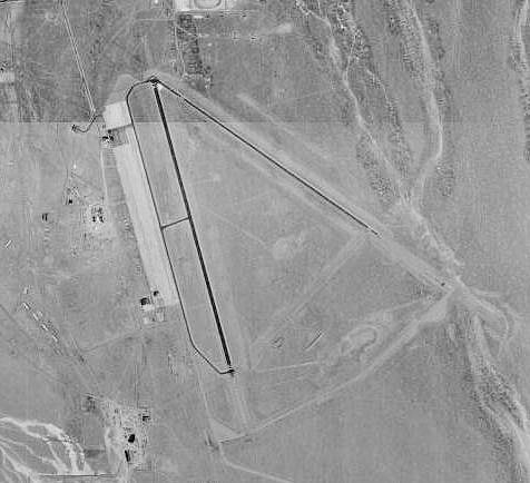 |
| USGS aerial image, 1999 |
| IATA: TPH – ICAO: KTPH – FAA LID: TPH |
| Summary |
| Airport type |
Public |
| Owner |
Nye County |
| Serves |
Tonopah, Nevada |
| Elevation AMSL |
5,430 ft / 1,655 m |
| Coordinates |
38°03′37″N 117°05′12″W / 38.06028°N 117.08667°W / 38.06028; -117.08667 |
| Runways |
| Direction |
Length |
Surface |
| ft |
m |
| 15/33 |
7,161 |
2,183 |
Asphalt |
| 11/29 |
6,196 |
1,889 |
Asphalt |
| Statistics (2009) |
| Aircraft operations |
12,727 |
| Based aircraft |
6 |
| Source: Federal Aviation Administration |
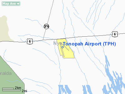
Tonopah Airport (IATA: TPH, ICAO: KTPH, FAA LID: TPH) is a county-owned public-use airport located seven nautical miles (13 km) east of the central business district of Tonopah, in Nye County, Nevada, United States.
Facilities and aircraft
Tonopah Airport covers an area of 3,820 acres (1,546 ha) at an elevation of 5,430 feet (1,655 m) above mean sea level. It has two asphalt paved runways: 15/33 is 7,161 by 80 feet (2,183 x 24 m) and 11/29 is 6,196 by 50 feet (1,889 x 15 m).
For the 12-month period ending November 30, 2009, the airport had 12,727 aircraft operations, an average of 34 per day: 74% general aviation, 25% air taxi, and 2% military. At that time there were 6 aircraft based at this airport: 5 single-engine and 1 helicopter.
The above content comes from Wikipedia and is published under free licenses – click here to read more.
Location & QuickFacts
| FAA Information Effective: | 2008-09-25 |
| Airport Identifier: | TPH |
| Airport Status: | Operational |
| Longitude/Latitude: | 117-05-13.7530W/38-03-36.7280N
-117.087154/38.060202 (Estimated) |
| Elevation: | 5426 ft / 1653.84 m (Surveyed) |
| Land: | 3820 acres |
| From nearest city: | 7 nautical miles E of Tonopah, NV |
| Location: | Nye County, NV |
| Magnetic Variation: | 15E (1995) |
Owner & Manager
| Ownership: | Publicly owned |
| Owner: | Nye County
MIKE MAHER - NYE CO MGR. 775-482=7399 |
| Address: | Nye County P O Box 153
Tonopah, NV 89049 |
| Phone number: | 775-482-8157
FBO PHONE (775) 482-3626. |
| Manager: | Samson Yao |
| Address: | Po Box 887
Tonopah, NV 89049 |
| Phone number: | 775-209-3760 |
Airport Operations and Facilities
| Airport Use: | Open to public |
| Wind indicator: | Yes |
| Segmented Circle: | Yes |
| Control Tower: | No |
| Lighting Schedule: | DUSK-DAWN
ACTVT MIRL RY 15/33 - CTAF. |
| Beacon Color: | Clear-Green (lighted land airport) |
| Landing fee charge: | No |
| Sectional chart: | Las Vegas |
| Region: | AWP - Western-Pacific |
| Boundary ARTCC: | ZLC - Salt Lake City |
| Tie-in FSS: | RNO - Reno |
| FSS Toll Free: | 1-800-WX-BRIEF |
| NOTAMs Facility: | TPH (NOTAM-d service avaliable) |
| Federal Agreements: | NGPY |
Airport Communications
| CTAF: | 123.000 |
| Unicom: | 123.000 |
Airport Services
| Fuel available: | 100LLA
FUEL AVBL 0700-1800 AFTER HOURS ON REQUEST CALL (775) 482-3626. |
| Airframe Repair: | MAJOR |
| Power Plant Repair: | MAJOR |
| Bottled Oxygen: | LOW |
| Bulk Oxygen: | NONE |
Runway Information
Runway 11/29
| Dimension: | 5464 x 50 ft / 1665.4 x 15.2 m |
| Surface: | ASPH, Good Condition |
| Weight Limit: | Single wheel: 30000 lbs.
Dual wheel: 66000 lbs.
Dual tandem wheel: 77000 lbs. |
| |
Runway 11 |
Runway 29 |
| Longitude: | 117-05-30.6240W | 117-04-34.6440W |
| Latitude: | 38-04-01.8050N | 38-03-30.8440N |
| Elevation: | 5425.00 ft | 5406.00 ft |
| Alignment: | 125 | 127 |
| Traffic Pattern: | Left | Left |
| Markings: | Basic, Fair Condition | Basic, Fair Condition |
| Runway End Identifier: | No | No |
| Centerline Lights: | No | No |
| Touchdown Lights: | No | No |
|
Runway 15/33
| Dimension: | 7057 x 80 ft / 2151.0 x 24.4 m |
| Surface: | ASPH, Good Condition |
| Weight Limit: | Single wheel: 30000 lbs. |
| Edge Lights: | Medium |
| |
Runway 15 |
Runway 33 |
| Longitude: | 117-05-33.8030W | 117-05-10.9230W |
| Latitude: | 38-04-03.1190N | 38-02-55.7430N |
| Elevation: | 5426.00 ft | 5392.00 ft |
| Alignment: | 127 | 127 |
| Traffic Pattern: | Left | Left |
| Markings: | Basic, Good Condition | Basic, Good Condition |
| Crossing Height: | 40.00 ft | 31.00 ft |
| VASI: | 2-light PAPI on left side
PAPI OTS INDEFLY. | 4-box on left side |
| Visual Glide Angle: | 3.00° | 3.00° |
| Runway End Identifier: | No | No |
| Centerline Lights: | No | No |
| Touchdown Lights: | No | No |
|
Radio Navigation Aids
| ID |
Type |
Name |
Ch |
Freq |
Var |
Dist |
| TPH | VORTAC | Tonopah | 119X | 117.20 | 17E | 3.1 nm |
| OAL | VORTAC | Coaldale | 124X | 117.70 | 17E | 32.5 nm |
Remarks
- ESTABD PRIOR TO 15 MAY 1959.
Images and information placed above are from
http://www.airport-data.com/airport/TPH/
We thank them for the data!
| General Info
|
| Country |
United States
|
| State |
NEVADA
|
| FAA ID |
TPH
|
| Latitude |
38-03-36.728N
|
| Longitude |
117-05-13.753W
|
| Elevation |
5426 feet
|
| Near City |
TONOPAH
|
We don't guarantee the information is fresh and accurate. The data may
be wrong or outdated.
For more up-to-date information please refer to other sources.
|
|


