 |
|
Pahute Mesa Airstrip Airport |
Coordinates: 37°06′10″N 116°18′48″W / 37.10278°N 116.31333°W / 37.10278; -116.31333
| Pahute Mesa Airstrip |
| IATA: none – ICAO: none – FAA LID: L23 |
| Summary |
| Airport type |
Private |
| Operator |
United States Department of Energy/Nevada |
| Location |
Mercury, Nevada |
| Elevation AMSL |
5,068 ft / 1,545 m |
| Runways |
| Direction |
Length |
Surface |
| ft |
m |
| 18/36 |
5,800 |
1,768 |
Asphalt |
| Source: Federal Aviation Administration |
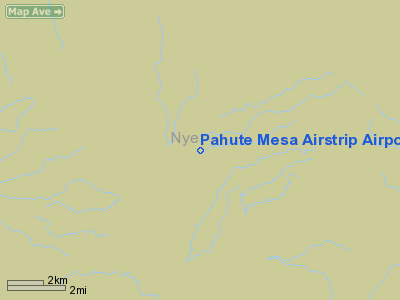
Pahute Mesa Airstrip (FAA LID: L23) is a private-use airport located 31 miles (50 km) northwest of the central business district of Mercury, in Nye County, Nevada, United States. The airport is owned by the United States Department of Energy. History
It was built in 1968 in Area 18 of the Nevada Test Site for transport planes to support the nuclear testing in the area.
Facilities
Pahute Mesa Airstrip covers an area of 35 acres (14 ha) which contains one asphalt paved runway designated 18/36 and measuring 5,800 by 100 feet (1,800 m × 30 m).
The above content comes from Wikipedia and is published under free licenses – click here to read more.
Location & QuickFacts
| FAA Information Effective: | 2008-09-25 |
| Airport Identifier: | L23 |
| Airport Status: | Operational |
| Longitude/Latitude: | 116-18-48.1740W/37-06-09.8180N
-116.313382/37.102727 (Estimated) |
| Elevation: | 5068 ft / 1544.73 m (Surveyed) |
| Land: | 35 acres |
| From nearest city: | 31 nautical miles NW of Mercury, NV |
| Location: | Nye County, NV |
| Magnetic Variation: | 14E (1985) |
Owner & Manager
| Ownership: | Publicly owned |
| Owner: | Nevada Dept Of Energy |
| Address: | Box 14100
Las Vegas, NV 89114 |
| Phone number: | 702-295-4015 |
| Manager: | Lawrence Draper |
| Address: | Nevada Dept Energy, Box 14100
Las Vegas, NV 89114 |
| Phone number: | 702-295-4015 |
Airport Operations and Facilities
| Airport Use: | Private |
| Wind indicator: | Yes |
| Segmented Circle: | No |
| Control Tower: | No |
| Landing fee charge: | No |
| Sectional chart: | Las Vegas |
| Region: | AWP - Western-Pacific |
| Boundary ARTCC: | ZLA - Los Angeles |
| Tie-in FSS: | RNO - Reno |
| FSS on Airport: | No |
| FSS Toll Free: | 1-800-WX-BRIEF |
Airport Services
| Airframe Repair: | NONE |
| Power Plant Repair: | NONE |
Runway Information
Runway 18/36
| Dimension: | 5800 x 100 ft / 1767.8 x 30.5 m |
| Surface: | ASPH, |
| |
Runway 18 |
Runway 36 |
| Traffic Pattern: | Left | Left |
| Markings: | Basic, Good Condition | Basic, Good Condition |
|
Radio Navigation Aids
| ID |
Type |
Name |
Ch |
Freq |
Var |
Dist |
| MCY | NDB | Mercury | | 326.00 | 16E | 31.7 nm |
| INS | TACAN | Indian Springs | 067X | | 15E | 43.9 nm |
| BTY | VORTAC | Beatty | 094X | 114.70 | 16E | 27.7 nm |
Remarks
- VFR DAY ONLY.
- AIRSTRIP WITHIN R-4808.
- OFFICIAL BUSINESS ONLY. PPR RQRD FROM DEPT OF ENERGY FOR ALL FLIGHTS.
- OWNER DESIRES AIRPORT NOT BE CHARTED
- FORMAL EVALUATION NOT RQRD, DATE ESTABD NOT KNOWN.
Images and information placed above are from
http://www.airport-data.com/airport/L23/
We thank them for the data!
| General Info
|
| Country |
United States
|
| State |
NEVADA
|
| FAA ID |
L23
|
| Latitude |
37-06-09.818N
|
| Longitude |
116-18-48.174W
|
| Elevation |
5068 feet
|
| Near City |
MERCURY
|
We don't guarantee the information is fresh and accurate. The data may
be wrong or outdated.
For more up-to-date information please refer to other sources.
|
|


