 |
|
| Lida Junction Airport |
| IATA: none – ICAO: none – FAA LID: 0L4 |
| Summary |
| Airport type |
Public |
| Operator |
United States Bureau of Land Management |
| Location |
Goldfield, Nevada |
| Elevation AMSL |
4,684 ft / 1,428 m |
| Coordinates |
37°29′09″N 117°11′27″W / 37.48583°N 117.19083°W / 37.48583; -117.19083Coordinates: 37°29′09″N 117°11′27″W / 37.48583°N 117.19083°W / 37.48583; -117.19083 |
| Runways |
| Direction |
Length |
Surface |
| ft |
m |
| 18/36 |
6,100 |
1,859 |
Soil |
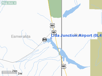
Lida Junction Airport (FAA LID: 0L4) is a public-use airport located 14 miles (23 km) south of the central business district of Goldfield, in Esmeralda County, Nevada, United States. The airport is owned by the United States Bureau of Land Management. History
The runway was built to provide access to the Kit Cat Ranch.
Facilities
Lida Junction Airport covers an area of 168 acres (68 ha) and has one runway:
- Runway 18/36: 6,100 x 80 ft (1,859 x 24 m), Surface: Dirt
The above content comes from Wikipedia and is published under free licenses – click here to read more.
Location & QuickFacts
| FAA Information Effective: | 2008-09-25 |
| Airport Identifier: | 0L4 |
| Airport Status: | Operational |
| Longitude/Latitude: | 117-11-27.2680W/37-29-08.7560N
-117.190908/37.485766 (Estimated) |
| Elevation: | 4684 ft / 1427.68 m (Estimated) |
| Land: | 168 acres |
| From nearest city: | 14 nautical miles S of Goldfield, NV |
| Location: | Esmeralda County, NV |
| Magnetic Variation: | 15E (1985) |
Owner & Manager
| Ownership: | Publicly owned |
| Owner: | Us Blm |
| Address: | P.o. Box 911
Tonopah, NV 89049 |
| Phone number: | 775-482-7800 |
| Manager: | Sandra Johnson |
| Address: | P.o. Box 517
Goldfield, NV 89013 |
| Phone number: | 775-485-6351 |
Airport Operations and Facilities
| Airport Use: | Open to public |
| Wind indicator: | No |
| Segmented Circle: | No |
| Control Tower: | No |
| Landing fee charge: | No |
| Sectional chart: | Las Vegas |
| Region: | AWP - Western-Pacific |
| Boundary ARTCC: | ZOA - Oakland |
| Tie-in FSS: | RNO - Reno |
| FSS on Airport: | No |
| FSS Toll Free: | 1-800-WX-BRIEF |
| NOTAMs Facility: | RNO (NOTAM-d service avaliable) |
Airport Communications
Airport Services
| Airframe Repair: | NONE |
| Power Plant Repair: | NONE |
| Bottled Oxygen: | NONE |
| Bulk Oxygen: | NONE |
Runway Information
Runway 18/36
| Dimension: | 6100 x 80 ft / 1859.3 x 24.4 m |
| Surface: | DIRT, Good Condition |
| |
Runway 18 |
Runway 36 |
| Traffic Pattern: | Left | Left |
| Markings: | None,
RWY 18/36 EDGES MARKED WITH WHITE TIRES. | None, |
| Runway End Identifier: | No | No |
| Centerline Lights: | No | No |
| Touchdown Lights: | No | No |
| Obstruction: | 45 ft tree, 465.0 ft from runway, 10 ft left of centerline, 11:1 slope to clear | , 50:1 slope to clear |
|
Radio Navigation Aids
| ID |
Type |
Name |
Ch |
Freq |
Var |
Dist |
| TPH | VORTAC | Tonopah | 119X | 117.20 | 17E | 33.6 nm |
| OAL | VORTAC | Coaldale | 124X | 117.70 | 17E | 41.5 nm |
| BTY | VORTAC | Beatty | 094X | 114.70 | 16E | 46.3 nm |
Remarks
- RY 18/36 HAS UNCONTROLLED VEH ACCESS.
- +30 FT POLE 408 FT FROM THLD RY 18 ON CNTRLN EXTDD.
Images and information placed above are from
http://www.airport-data.com/airport/0L4/
We thank them for the data!
| General Info
|
| Country |
United States
|
| State |
NEVADA
|
| FAA ID |
0L4
|
| Latitude |
37-29-08.756N
|
| Longitude |
117-11-27.268W
|
| Elevation |
4684 feet
|
| Near City |
GOLDFIELD
|
We don't guarantee the information is fresh and accurate. The data may
be wrong or outdated.
For more up-to-date information please refer to other sources.
|
|


