|
|
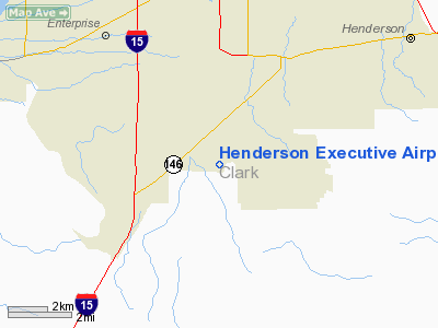
Henderson Executive Airport |
| Henderson Executive Airport |
 |
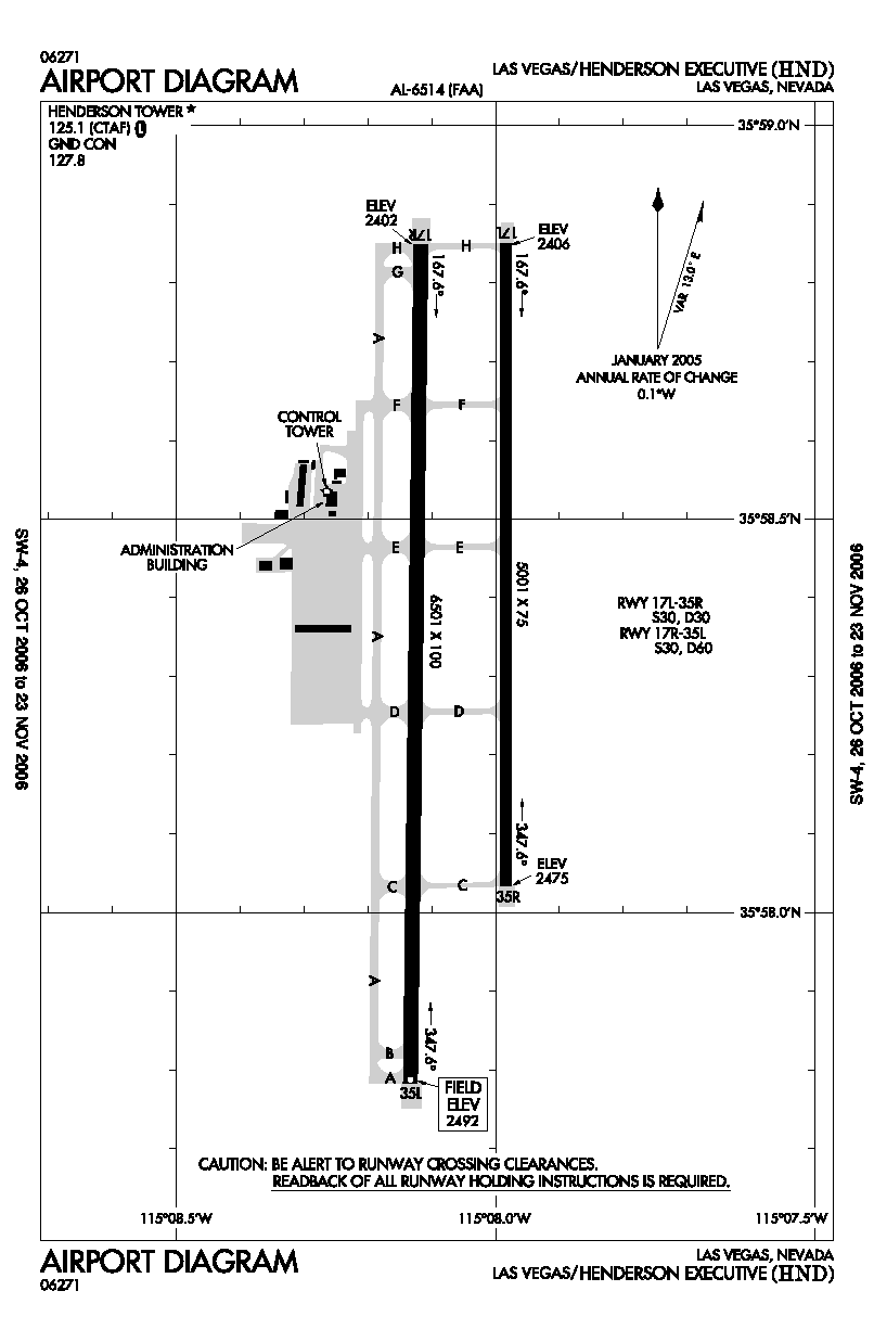
| FAA airport diagram |
| IATA: HSH – ICAO: KHND – FAA LID: HND |
| Summary |
| Airport type |
Public |
| Owner |
Clark County, Nevada |
| Operator |
Clark County Department of Aviation |
| Serves |
Las Vegas, Nevada |
| Elevation AMSL |
2,492 ft / 760 m |
| Coordinates |
35°58′22″N 115°08′04″W / 35.97278°N 115.13444°W / 35.97278; -115.13444 |
| Website |
www.hnd.aero |
| Runways |
| Direction |
Length |
Surface |
| ft |
m |
| 17R/35L |
6,501 |
1,982 |
Asphalt |
| 17L/35R |
5,001 |
1,524 |
Asphalt |
| Statistics (2008) |
| Aircraft operations |
71,323 |
| Based aircraft |
292 |
| Source: Federal Aviation Administration |
Henderson Executive Airport (IATA: HSH, ICAO: KHND, FAA LID: HND) is a public airport located 11 nautical miles (20 km; 13 mi) south of the central business district of Las Vegas, in Clark County, Nevada, United States. The airport is owned by Clark County and operated by the Clark County Department of Aviation. According to the FAA's National Plan of Integrated Airport Systems for 2009-2013, it is categorized as a reliever airport. It was originally known as Sky Harbor Airport, but was renamed in 1996 when it was purchased by Clark County to be used as a reliever airport for McCarran International Airport.
Although most U.S. airports use the same three-letter location identifier for the FAA and IATA, Henderson Executive Airport is assigned HND by the FAA and HSH by the IATA (which assigned HND to Haneda Airport in Tokyo, Japan). The airport's ICAO identifier is KHND
Facilities and aircraft
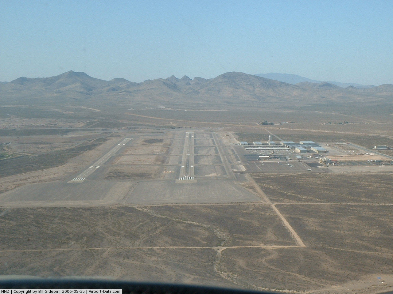
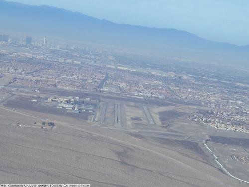
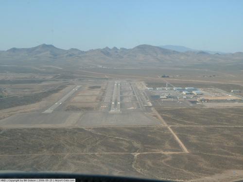
Henderson Executive Airport covers an area of 760 acres (310 ha) at an elevation of 2,492 feet (760 m) above mean sea level. It has two asphalt paved runways: 17R/35L measuring 6,501 by 100 feet (1,982 × 30 m) and 17L/35R measuring 5,001 by 75 feet (1,524 × 23 m).
For the 12-month period ending December 31, 2008, the airport had 71,323 aircraft operations, an average of 195 per day: 86% general aviation, 14% air taxi and <1% military aviation. At that time there were 292 aircraft based at this airport: 81% single-engine, 10% multi-engine, 9% jet and <1% helicopter.
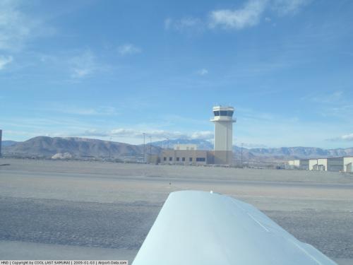
The terminal building houses car rental, flight school and line service facilities, as well as the Landings Restaurant.
The above content comes from Wikipedia and is published under free licenses – click here to read more.
 |
(Click on the photo to enlarge) |
 |
(Click on the photo to enlarge) |
 |
(Click on the photo to enlarge) |
Location & QuickFacts
| FAA Information Effective: | 2008-09-25 |
| Airport Identifier: | HND |
| Airport Status: | Operational |
| Longitude/Latitude: | 115-08-04.0000W/35-58-22.3000N
-115.134444/35.972861 (Estimated) |
| Elevation: | 2492 ft / 759.56 m (Surveyed) |
| Land: | 760 acres |
| From nearest city: | 11 nautical miles S of Las Vegas, NV |
| Location: | Clark County, NV |
| Magnetic Variation: | 13E (2005) |
Owner & Manager
| Ownership: | Publicly owned |
| Owner: | Clark County |
| Address: | P.o. Box 11005
Las Vegas, NV 89111 |
| Phone number: | 702-261-4802 |
| Manager: | Tom Donaldson
OPNS: TOM OKERLUND (702) 261-4851. |
| Address: | 3500 Executive Terminal Drive, Suite 100
Henderson, NV 89052 |
| Phone number: | 702-261-4802 |
Airport Operations and Facilities
| Airport Use: | Open to public |
| Wind indicator: | Yes |
| Segmented Circle: | Yes |
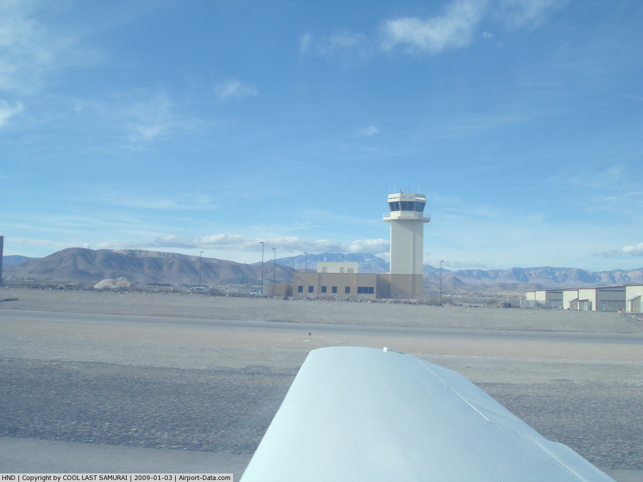
| Control Tower: | Yes |
| Lighting Schedule: | DUSK-DAWN
ACTVT MIRL RY 17R/35L & RY 17L/35R, PAPI RY 17R & RY 35L, PAPI RY 17L & RY 35R, REIL RYS 17R & 35L, REIL RYS 17L & 35R AND TWY - CTAF. REIL RYS 17L & 35R AVBL ONLY WHEN RY 17R/35L CLSD. |
| Beacon Color: | Clear-Green (lighted land airport) |
| Landing fee charge: | No |
| Sectional chart: | Las Vegas |
| Region: | AWP - Western-Pacific |
| Traffic Pattern Alt: | 1000 ft |
| Boundary ARTCC: | ZLA - Los Angeles |
| Tie-in FSS: | RNO - Reno |
| FSS on Airport: | No |
| FSS Toll Free: | 1-800-WX-BRIEF |
| NOTAMs Facility: | HND (NOTAM-d service avaliable) |
| Federal Agreements: | NGY |
Airport Communications
| CTAF: | 125.100 |
| Unicom: | 122.950 |
Airport Services
| Fuel available: | 100LLA
SELF-SVC FUEL 100 LL 24 HRS. |
| Bottled Oxygen: | NONE |
| Bulk Oxygen: | HIGH/LOW |
Runway Information
Runway 17L/35R
| Dimension: | 5001 x 75 ft / 1524.3 x 22.9 m |
| Surface: | ASPH, |
| Weight Limit: | Single wheel: 30000 lbs.
Dual wheel: 30000 lbs. |
| Edge Lights: | Medium
MIRL RY 17L/35R OTS UNLESS RY 17R/35L IS CLOSED. |
| |
Runway 17L |
Runway 35R |
| Longitude: | 115-07-58.6133W | 115-07-59.2284W |
| Latitude: | 35-58-51.1490N | 35-58-01.7103N |
| Elevation: | 2406.00 ft | 2475.00 ft |
| Alignment: | 127 | 0 |
| Traffic Pattern: | Left | Left |
| Markings: | Basic, Good Condition | Basic, Good Condition |
| VASI: | 4-light PAPI on left side
PAPI RY 17L OTS INDEFLY. | 4-light PAPI on left side
PAPI RY 35R OTS INDEFLY. |
| Visual Glide Angle: | 3.00° | 3.50° |
| Runway End Identifier: | Yes | Yes |
| Centerline Lights: | | No |
|
Runway 17R/35L
| Dimension: | 6501 x 100 ft / 1981.5 x 30.5 m |
| Surface: | ASPH, |
| Weight Limit: | Single wheel: 30000 lbs.
Dual wheel: 60000 lbs. |
| Edge Lights: | Medium
MIRL RY 17L/35R OTS UNLESS RY 17R/35L IS CLOSED. |
| |
Runway 17R |
Runway 35L |
| Longitude: | 115-08-07.1314W | 115-08-07.9226W |
| Latitude: | 35-58-51.2177N | 35-57-46.9483N |
| Elevation: | 2402.00 ft | 2492.00 ft |
| Alignment: | 127 | 0 |
| Traffic Pattern: | Left | Left |
| Markings: | Basic, Good Condition | Basic, Good Condition |
| Crossing Height: | 40.00 ft | 40.00 ft |
| VASI: | 4-light PAPI on left side | 4-light PAPI on left side
PAPI RY 35L OTS INDEFLY. |
| Visual Glide Angle: | 3.00° | 3.50° |
| Runway End Identifier: | Yes | Yes |
| Obstruction: | , 50:1 slope to clear | 44 ft road, 1095.0 ft from runway, 20:1 slope to clear |
|
Radio Navigation Aids
| ID |
Type |
Name |
Ch |
Freq |
Var |
Dist |
| LSV | TACAN | Nellis | 012X | | 15E | 17.2 nm |
| INS | TACAN | Indian Springs | 067X | | 15E | 45.0 nm |
| LAS | VORTAC | Las Vegas | 116X | 116.90 | 15E | 6.5 nm |
| BLD | VORTAC | Boulder City | 114X | 116.70 | 15E | 13.2 nm |
| VGT | VOT | North Las Vegas | | 108.20 | | 14.7 nm |
Remarks
- EXTENSIVE COMMERCIAL AIR TOUR TRAFFIC ARR FM SE AT DIFFERENT TIMES DURG DALGT HRS.
- RY 17L/35R IS CLSD SS-SR UNLESS RY 17R/35L IS CLSD.
Images and information placed above are from
http://www.airport-data.com/airport/HND/
We thank them for the data!
| General Info
|
| Country |
United States
|
| State |
NEVADA
|
| FAA ID |
HND
|
| Latitude |
35-58-34.912N
|
| Longitude |
115-07-57.975W
|
| Elevation |
2458 feet
|
| Near City |
LAS VEGAS
|
We don't guarantee the information is fresh and accurate. The data may
be wrong or outdated.
For more up-to-date information please refer to other sources.
|
|