|
|
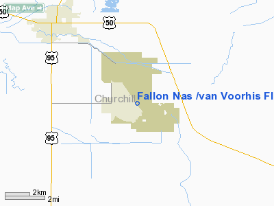
Fallon Nas /van Voorhis Fld/ Airport |
Naval Air Station Fallon
Van Voorhis Field |
 |
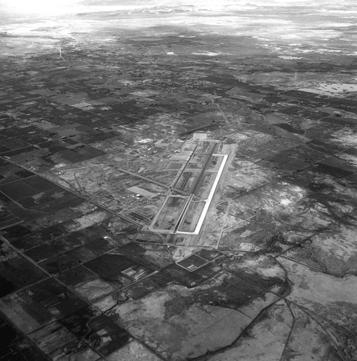 |
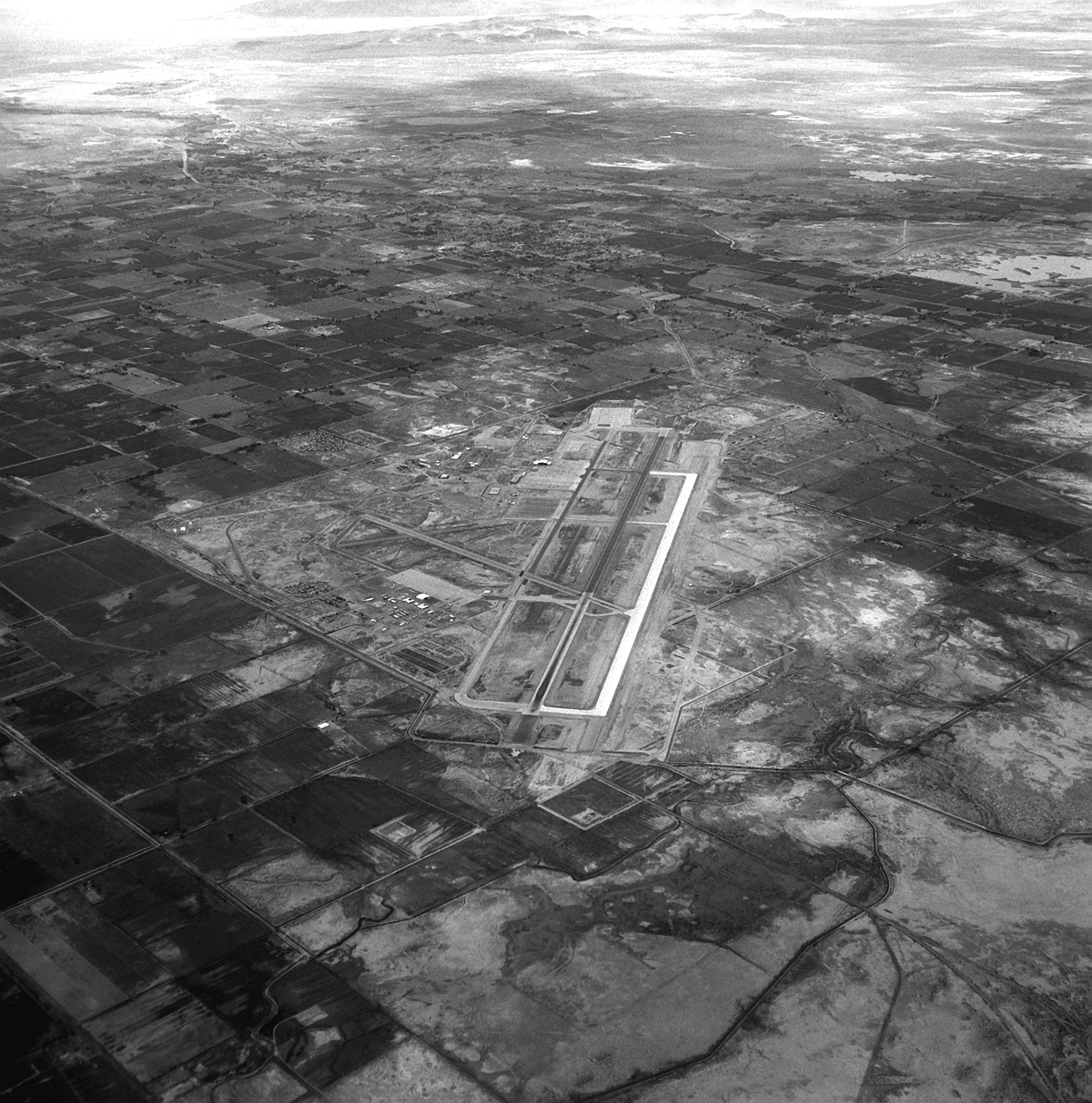
| Aerial view of NAS Fallon, 1988 |
| IATA: NFL – ICAO: KNFL – FAA LID: NFL |
| Summary |
| Airport type |
Military: Naval Air Station |
| Owner |
United States Navy |
| Location |
Churchill County, near Fallon, Nevada |
| Built |
June 10, 1944 |
| In use |
Active |
| Commander |
Captain Michael H. Glaser |
| Elevation AMSL |
3,934 ft / 1,199 m |
| Coordinates |
39°25′30″N 118°42′10″W / 39.425°N 118.70278°W / 39.425; -118.70278Coordinates: 39°25′30″N 118°42′10″W / 39.425°N 118.70278°W / 39.425; -118.70278 |
| Website |
www.cnic.navy.mil/fallon/ |
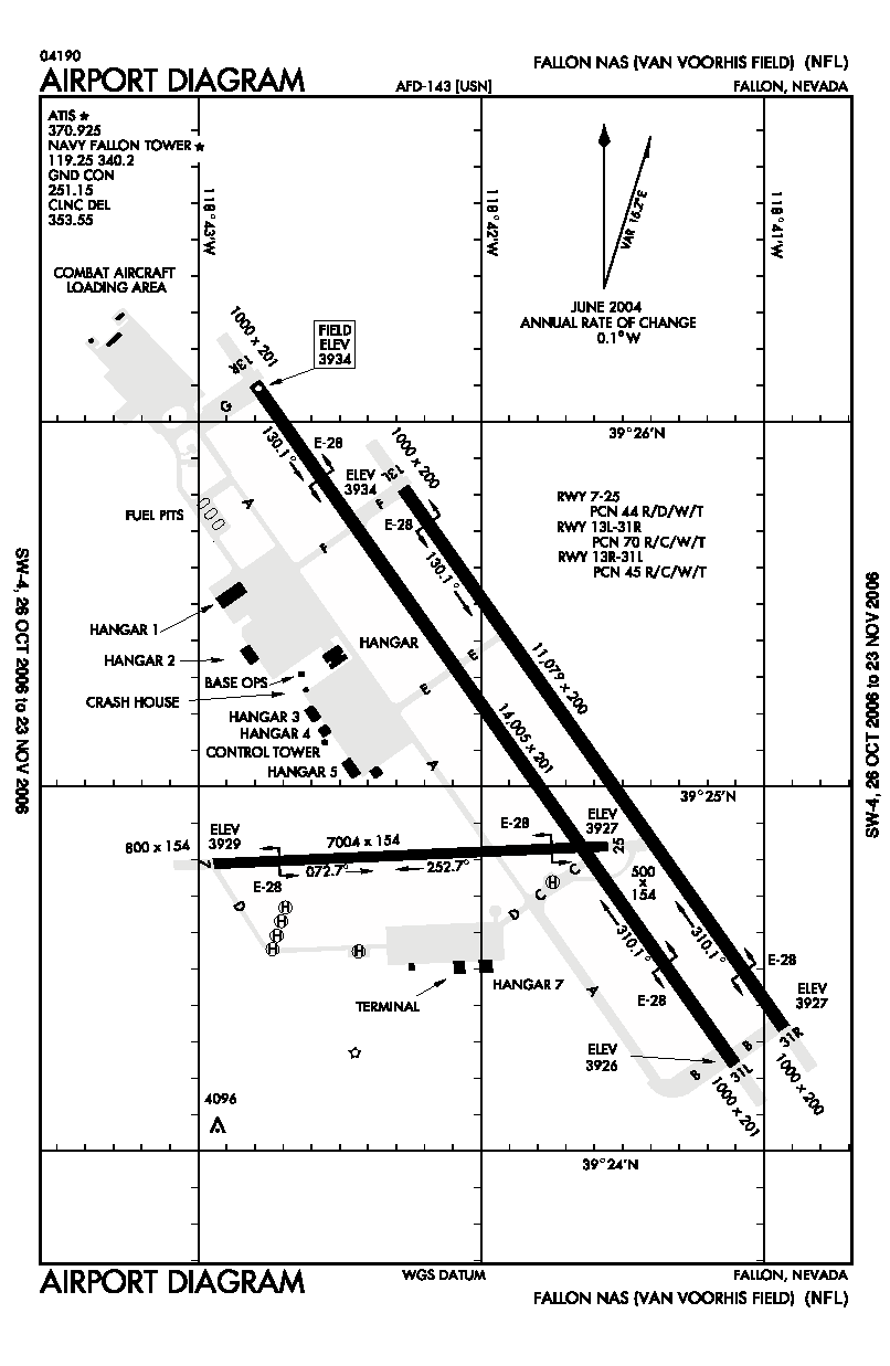
| Runways |
| Direction |
Length |
Surface |
| ft |
m |
| 7/25 |
7,004 |
2,135 |
PEM |
| 13L/31R |
11,077 |
3,376 |
Concrete |
| 13R/31L |
14,003 |
4,268 |
PEM |
| Source: FAA and official website |
Naval Air Station Fallon or NAS Fallon (IATA: NFL, ICAO: KNFL, FAA LID: NFL) is the United States Navy's premier air-to-air and air-to-ground training facility. It is located southeast of the city of Fallon in western Nevada in the United States. Since 1996, it has been home to the Naval Fighter Weapons School (TOPGUN), and the surrounding area contains 84,000 acres (340 km²) of bombing and electronic warfare ranges. It is also home to the Naval Strike and Air Warfare Center (NSAWC), which includes TOPGUN, the Carrier Airborne Early Warning Weapons School (TOPDOME) and the Navy Rotary Wing Weapons School. Navy SEAL Combat Search and Rescue (CSAR) training also takes place here.
The base is named Van Voorhis Field in honor of Lieutenant Bruce Van Voorhis (1908-1943) who was awarded a posthumous Medal of Honor
History
The airfield at NAS Fallon was originally built in 1942 as part of a defensive network to repel a hypothetical Japanese invasion of the west coast. It was soon taken over by the Navy for training use and has been used as such ever since with the exception of the period of 1946 to 1951, during which it was used by the Bureau of Indian Affairs. On January 1, 1972, the Navy recognized NAS Fallon's importance to naval aviation by upgrading the base to a major command. While NAS Fallon provides training for visiting Carrier air wings, the Strike Fighter Squadron 127 (VFA-127), the "Desert Bogeys", was the air station's only permanently based squadron from October 1987 until it was disestablished on March 23, 1996.
The Navy relocated its Navy Fighter Weapons School, or TOPGUN, from NAS Miramar to NAS Fallon in 1996, following the transfer of NAS Miramar to the Marine Corps and its redesignation as MCAS Miramar. This move resulted in the construction of a new ramp, hangars and academic buildings. The new command, the Naval Strike and Air Warfare Center (NSAWC), was established on July 11, 1996 and was a unification of TOPGUN, Strike University (Strike U), the Naval Strike Warfare Center, and TOPDOME, the Carrier Airborne Early Warning Weapons School. In addition to transferring the NSAWC squadron, a Navy Reserve adversary squadron, Fighter Squadron Composite THIRTEEN (VFC-13), the "Saints," was also permanently relocated from its former base at NAS Miramar to NAS Fallon. As a result, VFC-13 replaced the disestablished VFA-127 in the fighter adversary role.
Associated bombing ranges checker the surrounding Lahontan Valley and Dixie Valley, which is the next valley to the east. Dixie Valley also contains a simulated air defense network, including approximately 20 operational radar installations. Many demilitarized armored vehicles, including some exotics, have been scattered throughout the area, presumably for ambiance. Most of this area is publicly accessible, with the exception of areas immediately surrounding the radar installations.
The above content comes from Wikipedia and is published under free licenses – click here to read more.
Location & QuickFacts
| FAA Information Effective: | 2008-09-25 |
| Airport Identifier: | NFL |
| Airport Status: | Operational |
| Longitude/Latitude: | 118-42-03.5300W/39-24-59.7100N
-118.700981/39.416586 (Estimated) |
| Elevation: | 3934 ft / 1199.08 m (Estimated) |
| Land: | 0 acres |
| From nearest city: | 3 nautical miles NE of Fallon, NV |
| Location: | Churchill County, NV |
| Magnetic Variation: | 17E (1970) |
Owner & Manager
| Ownership: | Navy owned |
| Owner: | Us Navy |
| Address: | Oceanographic Ofc - Code 3142
Washington, DC 20373 |
| Manager: | Commanding Officer |
| Address: | Naval Air Station
Fallon, NV 89406 |
Airport Operations and Facilities
| Airport Use: | Private |
| Segmented Circle: | No |
| Control Tower: | Yes |
| Lighting Schedule: | DUSK-DAWN |
| Beacon Color: | Split-Clear-Green (lighted military airport) |
| Sectional chart: | Las Vegas |
| Region: | AWP - Western-Pacific |
| Boundary ARTCC: | ZOA - Oakland |
| Tie-in FSS: | RNO - Reno |
| FSS on Airport: | No |
| FSS Toll Free: | 1-800-WX-BRIEF |
| NOTAMs Facility: | NFL (NOTAM-d service avaliable) |
| Federal Agreements: | 3 |
Airport Services
| Bottled Oxygen: | NONE |
| Bulk Oxygen: | HIGH/LOW |
Runway Information
Runway 07/25
| Dimension: | 7004 x 154 ft / 2134.8 x 46.9 m |
| Surface: | PEM, |
| Pavement Class: | 44 /R/D/W/T |
| Edge Lights: | High |
| |
Runway 07 |
Runway 25 |
| Traffic Pattern: | Left | Left |
| Arresting: | E28B | E28B |
|
Runway 13L/31R
| Dimension: | 11077 x 200 ft / 3376.3 x 61.0 m |
| Surface: | CONC, |
| Pavement Class: | 70 /R/C/W/T |
| Edge Lights: | High |
| |
Runway 13L |
Runway 31R |
| Traffic Pattern: | Left | Left |
| Arresting: | E28 | E28 |
| VASI: | 4-light PAPI on left side | |
|
Runway 13R/31L
| Dimension: | 14003 x 201 ft / 4268.1 x 61.3 m |
| Surface: | PEM, |
| Pavement Class: | 45 /R/C/W/T |
| Weight Limit: | Single wheel: 93000 lbs.
Dual wheel: 120000 lbs.
Dual tandem wheel: 181000 lbs.
Dual dual tandem wheel: 552000 lbs.
ALSO ST154. |
| Edge Lights: | High |
| |
Runway 13R |
Runway 31L |
| Traffic Pattern: | Left | Left |
| Arresting: | E28 | E28 |
| Crossing Height: | 48.00 ft | 55.00 ft |
| VASI: | 4-light PAPI on left side | 4-light PAPI on left side |
| Visual Glide Angle: | 3.00° | 3.50° |
|
Radio Navigation Aids
| ID |
Type |
Name |
Ch |
Freq |
Var |
Dist |
| NFL | TACAN | Fallon | 082X | | 16E | 0.2 nm |
| HZN | VORTAC | Hazen | 088X | 114.10 | 17E | 15.0 nm |
| LLC | VORTAC | Lovelock | 112X | 116.50 | 16E | 43.0 nm |
| FMG | VORTAC | Mustang | 126X | 117.90 | 16E | 44.8 nm |
Remarks
- A-GEAR: E-28(B) APCH END RWY 31R NML DERIGGED.
- TFC PAT: ALL ACFT ACTIVATE LDG/TAXI LGT WHILE ON APCH. REDUCED RWY SEPARATION STD IN EFF FOR USN/USMC ACFT. INITIAL ALL RWY 7600'; OVERHEAD BREAK 5500'; NO OVERHEAD FOR RWY 07; PAT ALT 5000'. DUE EXTV TFC, ACFT REQ PRACTICE APCH EXP LEN DELAYS.
- NS ABTMT: WHEN DEP RWY 31L TURN RGT, HDG 040‘, OVER DEP END. ALL ACFT CTC ODO, DSN 890-2419/2458, C775-426-2419/2458, PRIOR TO FILING VFR, FOR NOISE SENSITIVE AREA BRIEFING.
- MISC: BASE OPS DSN 890-2419/2458, C775-426-2419/2458. LOGISTICS ACFT EXP ASR/PAR APCH.
- MISC: SKED OF FRTC AIRSPACE OUTSIDE OF PUBL AIRFIELD HRS WILL BE ALLOWED ONLY AFTER APVL HAS BEEN GRANTED BY THE NAS FALLON OPS OFFICER TO EXTN/MOD PUBL AIRFIELD HRS.
- JASU: 1(GTC-85) 1(NCPP-105) 2(NC-8A).
- FUEL - 4 HR PN RQR FOR ACFT REQ HOT REFUL. J8.
- FLUID: SP LOX.
- TRAN ALERT: NO TRAN MAINT/HGR SPACE OR DE-ICE AVBL.
- SEE FLIP AP/1 SUPPLEMENTARY ARPT RMK.
- RSTD - PPR 24 HR IN ADVANCE FOR TRAN SVC EXC MEDEVAC, SAR, DEPLOYED SQUADRONS/CVW OR SKED LOGISTICS FLT. PPR VALID ONLY 4 HR BYD ETA UNLESS RESKED, DSN 890-3415/3479, C775-426-3415/3479.
- CAUTION - RWY 13R CNTRLINE OPR ONLY DUE FOD HAZ. RADAR TWR 1.1 NM SW OF CTL TWR 167' AGL. LARGE MULTI-ENG ACFT FULL STOP/TOUCH AND GO LAND PAST E-28 A-GEAR AT APCH ENDS. TWY C, S APN TO APCH END RWY 25 VARIES IN WIDTH TAPERING TO 50' WIDE E OF RWY 13R-31L. TWY D, S APN TO APCH END RWY 07, 50' WIDE.
- CAUTION: EXTV BIRD ACT WITHIN APRX 15 NM OF ARPT FR SFC TO APRX 3000' AGL. GENERAL AVN ACFT OPR FR FALLON MUNI ARPT 5 NM NNW.
Images and information placed above are from
http://www.airport-data.com/airport/NFL/
We thank them for the data!
| General Info
|
| Country |
United States
|
| State |
NEVADA
|
| FAA ID |
NFL
|
| Latitude |
39-24-59.707N
|
| Longitude |
118-42-03.532W
|
| Elevation |
3934 feet
|
| Near City |
FALLON
|
We don't guarantee the information is fresh and accurate. The data may
be wrong or outdated.
For more up-to-date information please refer to other sources.
|
|