 |
|
| Eureka Airport |
| IATA: EUE – ICAO: none – FAA LID: 05U |
| Summary |
| Airport type |
Public |
| Owner |
County of Eureka |
| Serves |
Eureka, Nevada |
| Elevation AMSL |
5,954 ft / 1,815 m |
| Coordinates |
39°36′15″N 116°00′18″W / 39.60417°N 116.005°W / 39.60417; -116.005 |
| Runways |
| Direction |
Length |
Surface |
| ft |
m |
| 17/35 |
7,300 |
2,225 |
Asphalt |
| Statistics (2009) |
| Aircraft operations |
2,000 |
| Based aircraft |
5 |
| Source: Federal Aviation Administration |
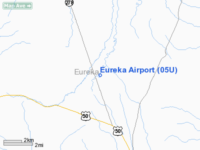
Eureka Airport (IATA: EUE, FAA LID: 05U) is a county-owned public-use airport located six nautical miles (11 km) northwest of the central business district of Eureka, a city in Eureka County, Nevada, United States. The airport is located within and towards the southern end of the Diamond Valley.
It is also known as Eureka County Airport and in 2007 it was named Booth Bailey Field, honoring Mr. Booth Bailey, a Eureka native and founder of Diamond Aviation, the airport's fixed base operator.
The airport is included in the FAA's National Plan of Integrated Airport Systems for 2009–2013, which categorizes it as a general aviation facility.
Facilities and aircraft
Eureka Airport covers an area of 800 acres (324 ha) at an elevation of 5,954 feet (1,815 m) above mean sea level. It has one runway designated 17/35 with an asphalt surface measuring 7,300 by 60 feet (2,225 x 18 m).
For the 12-month period ending July 31, 2009, the airport had 2,000 general aviation aircraft operations, an average of 166 per month. At that time there were 5 aircraft based at this airport, all single-engine.
The above content comes from Wikipedia and is published under free licenses – click here to read more.
Location & QuickFacts
| FAA Information Effective: | 2008-09-25 |
| Airport Identifier: | 05U |
| Airport Status: | Operational |
| Longitude/Latitude: | 116-00-18.2150W/39-36-15.0000N
-116.005060/39.604167 (Estimated) |
| Elevation: | 5954 ft / 1814.78 m (Surveyed) |
| Land: | 800 acres |
| From nearest city: | 6 nautical miles NW of Eureka, NV |
| Location: | Eureka County, NV |
| Magnetic Variation: | 15E (1985) |
Owner & Manager
| Ownership: | Publicly owned |
| Owner: | County Of Eureka
CTC RON DAMELE. |
| Address: | County Court House Box 257
Eureka, NV 89316 |
| Phone number: | 775-237-5372 |
| Manager: | John Walzl |
| Address: | P.o. Box 206
Eureka, NV 89316 |
| Phone number: | 775-237-6100 |
Airport Operations and Facilities
| Airport Use: | Open to public |
| Wind indicator: | Yes |
| Segmented Circle: | Yes |
| Control Tower: | No |
| Lighting Schedule: | DUSK-DAWN
HIRL RY 17/35 PRESENT LOW INTST DUSK-DAWN, TO INCR INTST ACTVT - CTAF. |
| Beacon Color: | Clear-Green (lighted land airport) |
| Landing fee charge: | No |
| Sectional chart: | Las Vegas |
| Region: | AWP - Western-Pacific |
| Boundary ARTCC: | ZLC - Salt Lake City |
| Tie-in FSS: | RNO - Reno |
| FSS on Airport: | No |
| FSS Toll Free: | 1-800-WX-BRIEF |
| NOTAMs Facility: | RNO (NOTAM-d service avaliable) |
| Federal Agreements: | NGSY |
Airport Communications
Airport Services
| Fuel available: | 100LLA |
| Airframe Repair: | MAJOR |
| Power Plant Repair: | MAJOR |
| Bottled Oxygen: | NONE |
| Bulk Oxygen: | NONE |
Runway Information
Runway 17/35
| Dimension: | 7300 x 60 ft / 2225.0 x 18.3 m |
| Surface: | ASPH, Good Condition |
| Surface Treatment: | Aggregate Friction Seal Coat |
| Weight Limit: | Single wheel: 30000 lbs. |
| Edge Lights: | High |
| |
Runway 17 |
Runway 35 |
| Traffic Pattern: | Left | Left |
| Markings: | Basic, Good Condition | Basic, Good Condition |
| Crossing Height: | 45.00 ft | 40.00 ft |
| VASI: | 2-light PAPI on left side | 2-light PAPI on left side |
| Visual Glide Angle: | 3.00° | 3.00° |
| Runway End Identifier: | No | No |
| Centerline Lights: | No | No |
| Touchdown Lights: | No | No |
| Obstruction: | , 50:1 slope to clear | 35 ft pline, 800.0 ft from runway, 17:1 slope to clear |
|
Radio Navigation Aids
| ID |
Type |
Name |
Ch |
Freq |
Var |
Dist |
Remarks
- (PAY PHONE) PAY PHONE AVAILABLE.
Images and information placed above are from
http://www.airport-data.com/airport/05U/
We thank them for the data!
| General Info
|
| Country |
United States
|
| State |
NEVADA
|
| FAA ID |
05U
|
| Latitude |
39-36-15.000N
|
| Longitude |
116-00-18.215W
|
| Elevation |
5954 feet
|
| Near City |
EUREKA
|
We don't guarantee the information is fresh and accurate. The data may
be wrong or outdated.
For more up-to-date information please refer to other sources.
|
|


