|
|
Elko Regional Airport
J.C. Harris Field |
 |
| FAA airport diagram |
| IATA: EKO – ICAO: KEKO – FAA LID: EKO |
| Summary |
| Airport type |
Public |
| Owner |
City of Elko |
| Serves |
Elko, Nevada |
| Elevation AMSL |
5,140 ft / 1,567 m |
| Coordinates |
40°49′30″N 115°47′30″W / 40.825°N 115.79167°W / 40.825; -115.79167 |
| Website |
www.ci.elko.nv.us/airport/... |
| Runways |
| Direction |
Length |
Surface |
| ft |
m |
| 5/23 |
7,214 |
2,199 |
Asphalt |
| 12/30 |
2,871 |
875 |
Asphalt |
| Statistics (2007) |
| Aircraft operations |
16,520 |
| Based aircraft |
69 |
| Source: Federal Aviation Administration |
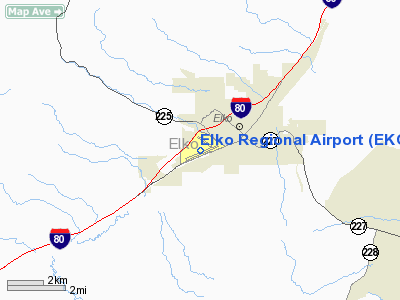
Elko Regional Airport (IATA: EKO, ICAO: KEKO, FAA LID: EKO), formerly known as Elko Municipal Airport, is a city-owned public-use airport located one mile (1.6 km) west of the central business district of Elko, a city in Elko County, Nevada, United States. This airport serves much of northeastern Nevada.
The airport was named J.C. Harris Field in 1975, in honor of Jess C. Harris, a sheriff from Elko who was known as "The Flying Sheriff". History
On April 6, 1926, when it was called Elko Airport, it was the terminus for the first scheduled air mail run in the United States. Varney Air Lines was the company that flew the initial service.
Facilities and aircraft
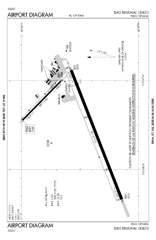
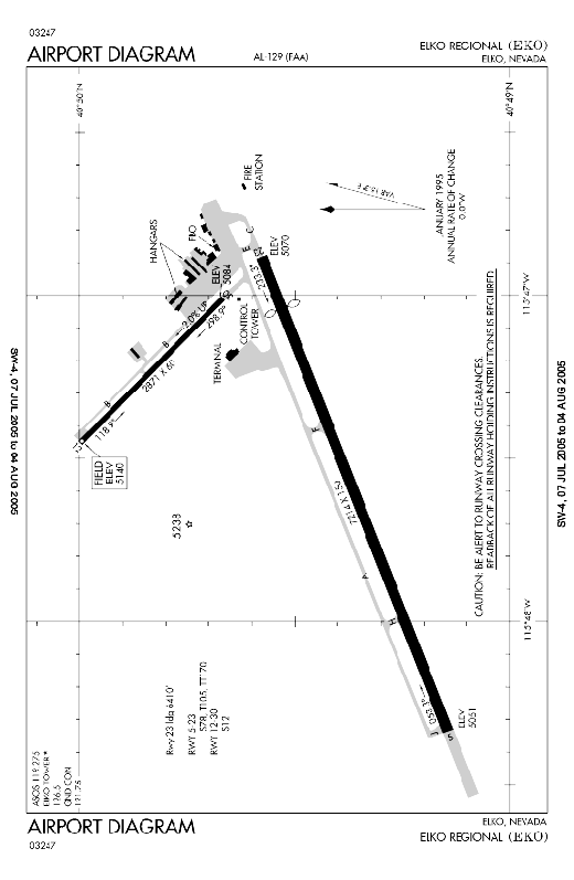
Elko Regional Airport covers an area of 700 acres (283 ha) which contains two asphalt paved runways: 5/23 measuring 7,214 x 150 ft (2,199 x 46 m) and 12/30 measuring 2,871 x 60 ft (875 x 18 m).
For the 12-month period ending August 31, 2007, the airport had 16,520 aircraft operations, an average of 45 per day: 73% general aviation, 27% air taxi and <1% military. At that time there were 69 aircraft based at this airport: 77% single-engine, 10% multi-engine, 6% jet and 7% helicopter.
Airlines and destinations
| Airlines |
Destinations |
| Delta Connection operated by SkyWest Airlines |
Salt Lake City |
The above content comes from Wikipedia and is published under free licenses – click here to read more.
Location & QuickFacts
| FAA Information Effective: | 2008-09-25 |
| Airport Identifier: | EKO |
| Airport Status: | Operational |
| Longitude/Latitude: | 115-47-30.1000W/40-49-29.7000N
-115.791694/40.824917 (Estimated) |
| Elevation: | 5140 ft / 1566.67 m (Surveyed) |
| Land: | 700 acres |
| From nearest city: | 1 nautical miles W of Elko, NV |
| Location: | Elko County, NV |
| Magnetic Variation: | 16E (1985) |
Owner & Manager
| Ownership: | Publicly owned |
| Owner: | City Of Elko |
| Address: | 975 Terminal Way
Elko, NV 89801 |
| Phone number: | 775-777-7190 |
| Manager: | Trent Moyers |
| Address: | 975 Terminal Way
Elko, NV 89801 |
| Phone number: | 775-777-7190 |
Airport Operations and Facilities
| Airport Use: | Open to public |
| Wind indicator: | Yes |
| Segmented Circle: | Yes |
| Control Tower: | No |
| Lighting Schedule: | DUSK-DAWN
ACTVT MIRL RY 05/23; VASI RY 05 & RY 23; REIL & MALSR RY 23 - 122.700. |
| Beacon Color: | Clear-Green (lighted land airport) |
| Landing fee charge: | No |
| Sectional chart: | Salt Lake City |
| Region: | AWP - Western-Pacific |
| Traffic Pattern Alt: | 1000 ft |
| Boundary ARTCC: | ZLC - Salt Lake City |
| Tie-in FSS: | RNO - Reno |
| FSS on Airport: | No |
| FSS Toll Free: | 1-800-WX-BRIEF |
| NOTAMs Facility: | EKO (NOTAM-d service avaliable) |
| Certification type/date: | I A U 05/1973
CLSD TO UNSKED ACR OPNS WITH MORE THAN 30 PSGR SEATS EXCP 24 HR PPR CALL AMGR 775-777-7190. |
| Federal Agreements: | NGY |
Airport Communications
| CTAF: | 123.000 |
| Unicom: | 123.000 |
Airport Services
| Fuel available: | 100 A |
| Airframe Repair: | MAJOR |
| Power Plant Repair: | MAJOR |
| Bottled Oxygen: | NONE |
| Bulk Oxygen: | NONE |
Runway Information
Runway 05/23
| Dimension: | 7214 x 150 ft / 2198.8 x 45.7 m |
| Surface: | ASPH, Good Condition |
| Surface Treatment: | Saw-cut or plastic Grooved |
| Weight Limit: | Single wheel: 78000 lbs.
Dual wheel: 105000 lbs.
Dual tandem wheel: 170000 lbs. |
| Edge Lights: | Medium |
| |
Runway 05 |
Runway 23 |
| Longitude: | 115-48-20.2413W | 115-46-52.8875W |
| Latitude: | 40-49-08.6861N | 40-49-34.6539N |
| Elevation: | 5051.00 ft | 5070.00 ft |
| Alignment: | 69 | 127 |
| ILS Type: | | LDA/DME
|
| Traffic Pattern: | Right | Left |
| Markings: | Non-precision instrument, Good Condition | Non-precision instrument, Good Condition |
| Crossing Height: | 43.00 ft | 34.00 ft |
| Displaced threshold: | 0.00 ft | 795.00 ft |
| VASI: | 4-box on left side | 4-box on left side |
| Visual Glide Angle: | 3.00° | 3.25° |
| Approach lights: | | MALSR |
| Runway End Identifier: | No | No |
| Centerline Lights: | No | No |
| Touchdown Lights: | No | No |
| Obstruction: | 24 ft road, 700.0 ft from runway, 325 ft right of centerline, 20:1 slope to clear | 99 ft pole, 2300.0 ft from runway, 450 ft right of centerline, 21:1 slope to clear
APCH RATIO 31:1 TO DSPLCD THR.
BUSHES 250'L. |
| Decleard distances: | Take off run available 7214.00 ft
Take off distance available 7214.00 ft
Actual stop distance available 7214.00 ft
Landing distance available 7214.00 ft
| Take off run available 7211.00 ft
Take off distance available 8211.00 ft
Actual stop distance available 7211.00 ft
Landing distance available 6410.00 ft
|
|
Runway 12/30
| Dimension: | 2871 x 60 ft / 875.1 x 18.3 m |
| Surface: | ASPH, Good Condition |
| Weight Limit: | Single wheel: 12000 lbs. |
| |
Runway 12 |
Runway 30 |
| Longitude: | 115-47-27.2898W | 115-47-00.5364W |
| Latitude: | 40-49-59.8868N | 40-49-40.1047N |
| Elevation: | 5140.00 ft | 5084.00 ft |
| Alignment: | 127 | 127 |
| Traffic Pattern: | Right | Left |
| Markings: | Basic, Good Condition | Basic, Good Condition |
| Runway End Identifier: | No | No |
| Centerline Lights: | No | No |
| Touchdown Lights: | No | No |
| Obstruction: | 26 ft pole, 650.0 ft from runway, 75 ft left of centerline, 17:1 slope to clear | 30 ft pole, 900.0 ft from runway, 100 ft left of centerline, 23:1 slope to clear |
|
Radio Navigation Aids
| ID |
Type |
Name |
Ch |
Freq |
Var |
Dist |
| LWL | VOR | Wells | | 114.20 | 17E | 41.6 nm |
| BQU | VOR/DME | Bullion | 092X | 114.50 | 17E | 4.2 nm |
Remarks
-
- VASI RWY 23 NOT TO BE USED BEYOND 4 NAUTICAL MILES DUE TO OBSCTRUCTION.
- RY 23 7211' FOR DEP; 6401' FOR LNDG.
- PPR FOR ALL ACFT OPNS OVER 100000 LBS CALL 775-777-7190.
Images and information placed above are from
http://www.airport-data.com/airport/EKO/
We thank them for the data!
| General Info
|
| Country |
United States
|
| State |
NEVADA
|
| FAA ID |
EKO
|
| Latitude |
40-49-29.734N
|
| Longitude |
115-47-30.107W
|
| Elevation |
5140 feet
|
| Near City |
ELKO
|
We don't guarantee the information is fresh and accurate. The data may
be wrong or outdated.
For more up-to-date information please refer to other sources.
|
|