 |
|
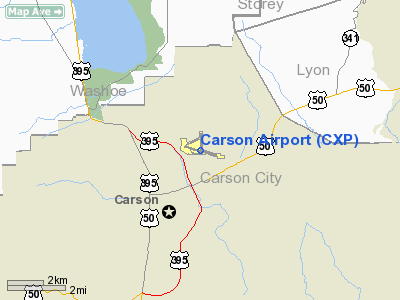
Carson Airport
Carson City Airport |
| IATA: CSN – ICAO: KCXP – FAA LID: CXP |
| Summary |
| Airport type |
Public |
| Operator |
Carson City Airport Authority |
| Serves |
Carson City, Nevada |
| Elevation AMSL |
4,697 ft / 1,432 m |
| Coordinates |
39°11′32″N 119°44′04″W / 39.19222°N 119.73444°W / 39.19222; -119.73444 |
| Website |
CarsonCity-Airport.com |
| Runways |
| Direction |
Length |
Surface |
| ft |
m |
| 9/27 |
5,906 |
1,800 |
Asphalt |
| Statistics (2009) |
| Aircraft operations |
83,500 |
| Based aircraft |
223 |
| Source: FAA and airport web site |
Carson Airport (IATA: CSN, ICAO: KCXP, FAA LID: CXP), also known as Carson City Airport, is a public use airport located three nautical miles (6 km) northeast of the central business district of Carson City, the capital of the U.S. state of Nevada. It is operated by the Carson City Airport Authority. According to the FAA's National Plan of Integrated Airport Systems for 2009-2013, it is categorized as a reliever airport.
Although most U.S. airports use the same three-letter location identifier for the FAA and IATA, this airport is assigned CXP by the FAA and CSN by the IATA (which assigned CXP to Tunggul Wulung Airport in Cilacap, Java, Indonesia). The airport's ICAO identifier is KCXP.
Facilities and aircraft
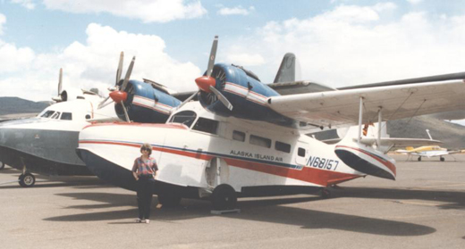 | |
Grumman Goose amphibian aircraft at Carson Airport |
Carson Airport covers an area of 632 acres (256 ha) at an elevation of 4,697 feet (1,432 m) above mean sea level. It has one runway designated 9/27 with an asphalt surface measuring 5,906 by 75 feet (1,800 x 23 m).
For the 12-month period ending June 30, 2009, the airport had 83,500 aircraft operations, an average of 228 per day: 91% general aviation and 9% air taxi. At that time there were 223 aircraft based at this airport: 76% single-engine, 11% multi-engine, 3% jet, <1% helicopter, 1% glider and 9% ultralight. Based aircraft include several amphibians which frequently fly to and land in nearby Lake Tahoe.
The above content comes from Wikipedia and is published under free licenses – click here to read more.
Location & QuickFacts
| FAA Information Effective: | 2008-09-25 |
| Airport Identifier: | CXP |
| Airport Status: | Operational |
| Longitude/Latitude: | 119-44-04.0000W/39-11-32.0000N
-119.734444/39.192222 (Estimated) |
| Elevation: | 4697 ft / 1431.65 m (Surveyed) |
| Land: | 632 acres |
| From nearest city: | 3 nautical miles NE of Carson City, NV |
| Location: | Carson City County, NV |
| Magnetic Variation: | 16E (1985) |
Owner & Manager
| Ownership: | Publicly owned |
| Owner: | City Airport Authority |
| Address: | 2600 College Parkway, No. 6
Carson City, NV 89706 |
| Phone number: | 775-885-9100 |
| Manager: | Yvon Weaver |
| Address: | 2600 E. College Parkway, No. 6
Carson City, NV 89706 |
| Phone number: | 775-885-9100 |
Airport Operations and Facilities
| Airport Use: | Open to public |
| Wind indicator: | Yes |
| Segmented Circle: | Yes |
| Control Tower: | No |
| Lighting Schedule: | DUSK-DAWN |
| Beacon Color: | Clear-Green (lighted land airport) |
| Landing fee charge: | No
FEE FOR TIEDOWN ONLY. |
| Sectional chart: | San Francisco |
| Region: | AWP - Western-Pacific |
| Traffic Pattern Alt: | 800 ft |
| Boundary ARTCC: | ZOA - Oakland |
| Tie-in FSS: | RNO - Reno |
| FSS on Airport: | No |
| FSS Toll Free: | 1-800-WX-BRIEF |
| NOTAMs Facility: | CXP (NOTAM-d service avaliable) |
| Federal Agreements: | NGY |
Airport Communications
| CTAF: | 123.000 |
| Unicom: | 123.000 |
Airport Services
| Fuel available: | 100 100LLA
FUEL SELF-SERVICE 24 HRS. |
| Airframe Repair: | MAJOR |
| Power Plant Repair: | MAJOR |
| Bottled Oxygen: | HIGH |
| Bulk Oxygen: | HIGH |
Runway Information
Runway 09/27
| Dimension: | 5906 x 75 ft / 1800.1 x 22.9 m |
| Surface: | ASPH, Good Condition |
| Surface Treatment: | Aggregate Friction Seal Coat |
| Weight Limit: | Single wheel: 30000 lbs. |
| Edge Lights: | Medium |
| |
Runway 09 |
Runway 27 |
| Longitude: | 119-44-39.9477W | 119-43-28.0767W |
| Latitude: | 39-11-40.3687N | 39-11-23.7017N |
| Elevation: | 4700.00 ft | 4686.00 ft |
| Alignment: | 107 | 127 |
| Traffic Pattern: | Right | Left |
| Markings: | Non-precision instrument, Good Condition | Non-precision instrument, Good Condition |
| Crossing Height: | 35.00 ft | 26.00 ft |
| VASI: | nonstandard system
NSTD PSIL SINGLE BOX LEFT SIDE. | 2-box on left side |
| Visual Glide Angle: | 4.00° | 3.00° |
| Runway End Identifier: | No | No |
| Centerline Lights: | No | No |
| Touchdown Lights: | No | No |
| Obstruction: | 30 ft road, 800.0 ft from runway, 20:1 slope to clear | , 50:1 slope to clear |
|
Radio Navigation Aids
| ID |
Type |
Name |
Ch |
Freq |
Var |
Dist |
| NFL | TACAN | Fallon | 082X | | 16E | 49.8 nm |
| SWR | VOR/DME | Squaw Valley | 079X | 113.20 | 16E | 24.9 nm |
| FMG | VORTAC | Mustang | 126X | 117.90 | 16E | 20.7 nm |
| HZN | VORTAC | Hazen | 088X | 114.10 | 17E | 39.4 nm |
Remarks
- ULTRALIGHT ACTIVITY ON AND INVOF ARPT.
Images and information placed above are from
http://www.airport-data.com/airport/CXP/
We thank them for the data!
| General Info
|
| Country |
United States
|
| State |
NEVADA
|
| FAA ID |
CXP
|
| Latitude |
39-11-32.000N
|
| Longitude |
119-44-04.000W
|
| Elevation |
4697 feet
|
| Near City |
CARSON CITY
|
We don't guarantee the information is fresh and accurate. The data may
be wrong or outdated.
For more up-to-date information please refer to other sources.
|
|


