 |
|
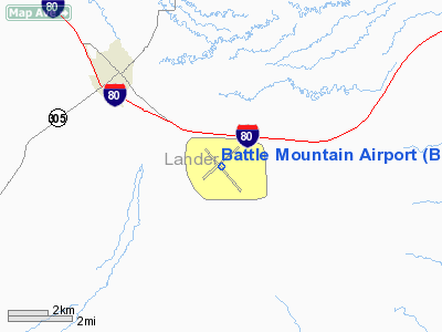
| Battle Mountain Airport |
| IATA: BAM – ICAO: KBAM – FAA LID: BAM |
| Summary |
| Airport type |
Public |
| Operator |
Lander County |
| Serves |
Battle Mountain, Nevada |
| Location |
Lander County, near Battle Mountain, Nevada |
| Elevation AMSL |
4,532 ft / 1,381 m |
| Coordinates |
40°35′59″N 116°52′34″W / 40.59972°N 116.87611°W / 40.59972; -116.87611 |
| Runways |
| Direction |
Length |
Surface |
| ft |
m |
| 12/30 |
7,300 |
2,225 |
Asphalt |
| 3/21 |
7,299 |
2,225 |
Asphalt |
| Helipads |
| Number |
Length |
Surface |
| ft |
m |
| H1 |
60 |
18 |
Concrete |
| H2 |
60 |
18 |
Concrete |
| Source: Federal Aviation Administration |
Battle Mountain Airport (IATA: BAM, ICAO: KBAM, FAA LID: BAM), also known as Lander County Airport, is a public-use airport located 3 miles (5 km) southeast of the central business district of Battle Mountain, Nevada, United States. This general aviation airport is owned by Lander County and operated by the Battle Mountain Airport Authority. History
The airport was built by the United States Army Air Force about 1942, and was known as Battle Mountain Flight Strip. It was an emergency landing airfield by the Reno Army Air Base for military aircraft on training flights. It was also designated as a CAA Intermediate Field for civil aircraft emergency use. It was closed after World War II, and was turned over for local government use by the War Assets Administration (WAA).
Facilities
Battle Mountain Airport covers an area of 1,066 acres (431 ha) which contains two runways and two helipads:
- Runway 3/21: 7,299 x 150 ft (2,225 x 46 m), Surface: Asphalt
- Runway 12/30: 7,300 x 100 ft (2,225 x 30 m), Surface: Asphalt
- Helipad H1: 60 x 60 ft (18 x 18 m), Surface: Concrete
- Helipad H2: 60 x 60 ft (18 x 18 m), Surface: Concrete
Organizations
BAM is home to the Battle Mountain Air Attack Base which is run by the Bureau of Land Management. The Air Attack Base provides air tanker support for fire suppression in northern Nevada. The Nevada Division of Forestry also operates an air tanker base at BAM.
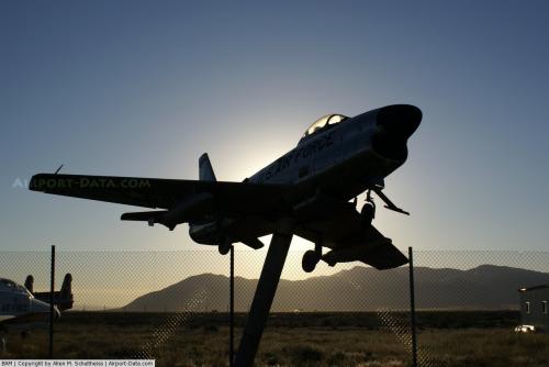
Displays
Several aerospace exhibits are available at the airport.
The above content comes from Wikipedia and is published under free licenses – click here to read more.
 |
(Click on the photo to enlarge) |
Location & QuickFacts
| FAA Information Effective: | 2008-09-25 |
| Airport Identifier: | BAM |
| Airport Status: | Operational |
| Longitude/Latitude: | 116-52-27.6090W/40-35-56.5650N
-116.874336/40.599046 (Estimated) |
| Elevation: | 4532 ft / 1381.35 m (Estimated) |
| Land: | 1066 acres |
| From nearest city: | 3 nautical miles SE of Battle Mountain, NV |
| Location: | Lander County, NV |
| Magnetic Variation: | 17E (1980) |
Owner & Manager
| Ownership: | Publicly owned |
| Owner: | Lander County |
| Address: | 315 South Humbolt St.
Battle Mountain, NV 89820 |
| Phone number: | 775-635-2885 |
| Manager: | Gene Etcheverry
COUNTY MANAGER |
| Address: | 315 South Humbolt
Battle Mountain, NV 89820 |
| Phone number: | 775-635-2885 |
Airport Operations and Facilities
| Airport Use: | Open to public |
| Wind indicator: | Yes |
| Segmented Circle: | Yes |
| Control Tower: | No |
| Lighting Schedule: | DUSK-DAWN
ACTVT MIRL RYS 03/21 & 12/30 AND PERIMETER LGTS H1 - CTAF. |
| Beacon Color: | Clear-Green (lighted land airport) |
| Landing fee charge: | No |
| Sectional chart: | Salt Lake City |
| Region: | AWP - Western-Pacific |
| Boundary ARTCC: | ZLC - Salt Lake City |
| Tie-in FSS: | RNO - Reno |
| FSS on Airport: | No |
| FSS Toll Free: | 1-800-WX-BRIEF |
| NOTAMs Facility: | RNO (NOTAM-d service avaliable) |
| Federal Agreements: | NGY2 |
Airport Communications
| CTAF: | 122.800 |
| Unicom: | 122.800 |
Airport Services
| Fuel available: | 100LLA |
| Airframe Repair: | MAJOR |
| Power Plant Repair: | MAJOR |
| Bottled Oxygen: | NONE |
| Bulk Oxygen: | NONE |
Runway Information
Runway 03/21
| Dimension: | 7299 x 150 ft / 2224.7 x 45.7 m |
| Surface: | ASPH, |
| Weight Limit: | Single wheel: 30000 lbs.
Dual wheel: 125000 lbs. |
| Edge Lights: | Medium |
| |
Runway 03 |
Runway 21 |
| Longitude: | 116-53-05.8860W | 116-51-54.3980W |
| Latitude: | 40-35-37.8100N | 40-36-25.0370N |
| Elevation: | 4531.00 ft | 4526.00 ft |
| Alignment: | 49 | 127 |
| Traffic Pattern: | Left | Left |
| Markings: | Non-precision instrument, Good Condition | Non-precision instrument, Good Condition |
| Crossing Height: | 26.00 ft | 45.00 ft |
| VASI: | 2-box on right side | 4-light PAPI on left side |
| Visual Glide Angle: | 3.00° | 3.00° |
| Runway End Identifier: | No | No |
| Centerline Lights: | No | No |
| Touchdown Lights: | No | No |
|
Runway 12/30
| Dimension: | 7300 x 100 ft / 2225.0 x 30.5 m |
| Surface: | ASPH, Good Condition |
| Weight Limit: | Single wheel: 30000 lbs.
Dual wheel: 104000 lbs. |
| Edge Lights: | Medium |
| |
Runway 12 |
Runway 30 |
| Longitude: | 116-52-56.0670W | 116-51-54.0880W |
| Latitude: | 40-36-18.9660N | 40-35-24.4470N |
| Elevation: | 4532.00 ft | 4531.00 ft |
| Alignment: | 127 | 127 |
| Traffic Pattern: | Left | Left |
| Markings: | Basic, Good Condition | Basic, Good Condition |
| Runway End Identifier: | No | No |
| Centerline Lights: | No | No |
| Touchdown Lights: | No | No |
|
Helipad H1
| Dimension: | 60 x 60 ft / 18.3 x 18.3 m |
| Surface: | CONC, Good Condition |
| |
Runway H1 |
Runway |
| Traffic Pattern: | Left | Left |
|
Helipad H2
| Dimension: | 60 x 60 ft / 18.3 x 18.3 m |
| Surface: | CONC, Good Condition |
| |
Runway H2 |
Runway |
| Traffic Pattern: | Left | Left |
|
Radio Navigation Aids
| ID |
Type |
Name |
Ch |
Freq |
Var |
Dist |
| INA | VOR/DME | Winnemucca | 019X | 108.20 | 16E | 46.4 nm |
| BAM | VORTAC | Battle Mountain | 059X | 112.20 | 18E | 2.8 nm |
Images and information placed above are from
http://www.airport-data.com/airport/BAM/
We thank them for the data!
| General Info
|
| Country |
United States
|
| State |
NEVADA
|
| FAA ID |
BAM
|
| Latitude |
40-35-56.565N
|
| Longitude |
116-52-27.609W
|
| Elevation |
4532 feet
|
| Near City |
BATTLE MOUNTAIN
|
We don't guarantee the information is fresh and accurate. The data may
be wrong or outdated.
For more up-to-date information please refer to other sources.
|
|


