|
 |
|
||||
|
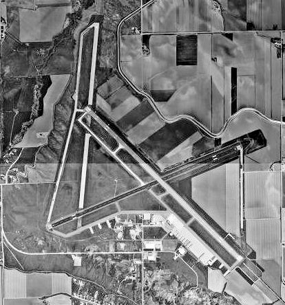
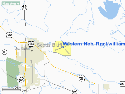
Western Nebraska Regional Airport (IATA: BFF, ICAO: KBFF, FAA LID: BFF), also known as William B. Heilig Field, is a public airport located three nautical miles (6 km) east of the central business district of Scottsbluff, a city in Scotts Bluff County, Nebraska, United States. It is owned by the Airport Authority of Scotts Bluff County. It is served by one commercial airline, with service subsidized by the Essential Air Service program. Facilities and aircraftWestern Nebraska Regional Airport covers an area of 1,806 acres (731 ha) at an elevation of 3,967 feet (1,209 m) above mean sea level. It has two asphalt paved runways: 5/23 is 8,002 by 150 feet (2,439 x 46 m) and 12/30 is 8,279 by 150 feet (2,523 x 46 m). For the 12-month period ending May 31, 2008, the airport had 27,965 aircraft operations, an average of 76 per day: 89% general aviation, 8% scheduled commercial, 2% air taxi and 1% military. At that time there were 53 aircraft based at this airport: 87% single-engine and 13% multi-engine. Airlines and destinations
HistoryWestern Nebraska Regional Airport was first established in 1934. The original airport had a hangar, commercial airline connections, air mail service, lighted fields, a weather bureau station, and a strong record as a civilian pilot training facility . With the United States entry into World War II, Scottsbluff actively promoted the use of its municipal airport for military/defense purposes. On 5 September 1942, an announcement was made that Scottsbluff was selected as one of seven satellite air bases that would be located in Nebraska. Twenty-eight farms were vacated so construction could begin at a cost of 5.5 million dollars. The original Scottsbluff Municipal Airport was forced to close to make way for the new airfield's construction. The old airport later became a prisoner of war camp. Construction began at the new base on 7 September 1942. A temporary railroad spur was constructed to the base, and some 600,000 cubic yards (460,000 m) of concrete for three runways was poured in forty-five days. There were approximately 108 buildings on the ground including barracks, mess halls, officers' quarters, warehouses, a hangar, a camouflage instruction building, and a bombsight storage building. 108 buildings and structures were constructed at the airfield. Scottsbluff Army AirfieldThe base was first occupied as early as 11 October 1942 and was assigned to Second Air Force. Initially, Scottsbluff Army Airfield was a satellite to Casper Army Air Field, Wyoming. The first troops arrived 4 December 1942. The 4190th Army Air Force Base Unit was the host organization at Scottsbluff AAF. The original mission of Scottsbluff AAF was to train aircrews of Boeing B-17 Flying Fortresses and Consolidated B-24 Liberators bombers. Crews based at Casper AAF Wyoming final training at Scottsbluff. All training aircraft at the airfield were assigned to the 4190th AAFBU. In 1944 base command was transferred from Second Air Force to the 1st Troop Carrier Command, and became a satellite field of Alliance Army Airfield. The 1st TCC used the facility training Douglas C-47 Skytrain and glider crews. Aircraft and radio maintenance personnel also trained here. Civil useThe airfield closed on 31 December 1945. The War Department handed over control of the airport to the City of Scottsbluff in 1947. Buildings and structures which were not part of the transfer were sold by the U.S. Government in separate agreements, and in most cases were removed from the site. The USAF continued to use the airport for military training regularly until 1950. In July 1970, Scotts Bluff County took control and has had it ever since. The county continues to operate the facility as the William B. Helig Field, serving the regional area of the Nebraska Panhandle for all public travel and aeronautical needs and is connected by commercial airlines. In the summer of 2003, the county created an Airport Authority Board which has since made major improvements on and around the airport property. New improvements include a new terminal building, wildlife fence, fire equipment, and remodeling the fire station. Future projects include runway lighting and resurfacing. The board is currently working with local law enforcement and the TSA for security screening. The above content comes from Wikipedia and is published under free licenses – click here to read more.
Location & QuickFacts
Owner & Manager
Airport Operations and Facilities
Airport Communications
Airport Services
Runway InformationRunway 05/23
Runway 12/30
Radio Navigation Aids
Remarks
Images and information placed above are from We thank them for the data!
We don't guarantee the information is fresh and accurate. The data may
be wrong or outdated.
|
||||||||||||||||||||||||||||||||||||||||||||||||||||||||||||||||||||||||||||||||||||||||||||||||||||||||||||||||||||||||||||||||||||||||||||||||||||||||||||||||||||||||||||||||||||||||||||||||||||||||||||||||||||||||||||||||||||||||||||||||||||||||||||||||||||||||||||||||||||||||||||||||||||||||||||||||||||||||||||||||||||||||||||||||||||||||||||||||||||||||||

 |
|
Copyright 2004-2026 © by Airports-Worldwide.com, Vyshenskoho st. 36, Lviv 79010, Ukraine Legal Disclaimer |