 |
|
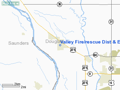
Valley Fire/rescue Dist & Emerg Service Heliport |
Location & QuickFacts
| FAA Information Effective: | 2008-09-25 |
| Airport Identifier: | 48NE |
| Airport Status: | Operational |
| Longitude/Latitude: | 096-20-51.0870W/41-18-39.9970N
-96.347524/41.311110 (Estimated) |
| Elevation: | 1140 ft / 347.47 m (Estimated) |
| Land: | 1 acres |
| From nearest city: | 0 nautical miles N of Valley, NE |
| Location: | Douglas County, NE |
| Magnetic Variation: | 06E (1985) |
Owner & Manager
| Ownership: | Publicly owned |
| Owner: | Valley Fire/rescue Dist No 5 |
| Address: | 210 W. Church Box 554
Valley, NE 68064-0554 |
| Phone number: | 402-359-5552 |
| Manager: | Byron Ueckert |
| Address: | 210 W. Church Box 554
Valley, NE 68064-0554 |
| Phone number: | 402-490-5926
OR 402-359-5243. |
Airport Operations and Facilities
| Airport Use: | Private |
| Wind indicator: | Yes |
| Segmented Circle: | No
SEGMENTED TRIANGLE- WITH LETTER 'H'. |
| Control Tower: | No |
| Lighting Schedule: | DUSK-DAWN |
| Beacon Color: | Clear-Green-Yellow (heliport) |
| Landing fee charge: | No |
| Sectional chart: | Omaha |
| Region: | ACE - Central |
| Boundary ARTCC: | ZMP - Minneapolis |
| Tie-in FSS: | OLU - Columbus |
| FSS on Airport: | No |
| FSS Toll Free: | 1-800-WX-BRIEF |
Runway Information
Helipad H1
| Dimension: | 25 x 25 ft / 7.6 x 7.6 m |
| Surface: | CONC, Good Condition |
| Edge Lights: | Low |
| |
Runway H1 |
Runway |
| Traffic Pattern: | Left | Left |
|
Radio Navigation Aids
| ID |
Type |
Name |
Ch |
Freq |
Var |
Dist |
| FET | NDB | Fremont | | 311.00 | 06E | 11.4 nm |
| AHQ | NDB | Wahoo | | 400.00 | 07E | 12.1 nm |
| MLE | NDB | Millard | | 371.00 | 06E | 12.7 nm |
| OM | NDB | Gerfi | | 320.00 | 05E | 18.0 nm |
| PMV | NDB | Plattsmouth | | 329.00 | 06E | 29.6 nm |
| LN | NDB | Potts | | 385.00 | 06E | 38.8 nm |
| SWT | NDB | Seward | | 269.00 | 06E | 43.9 nm |
| AFK | NDB | Nebraska City | | 347.00 | 05E | 47.8 nm |
| PLT | NDB | Platte Center | | 407.00 | 08E | 47.9 nm |
| HNR | NDB | Harlan | | 272.00 | 05E | 48.1 nm |
| OFF | TACAN | Offutt | 054X | | 05E | 23.4 nm |
| TQE | VOR | Tekamah | | 108.40 | 07E | 28.0 nm |
| SCB | VOR/DME | Scribner | 47X | 111.00 | 06E | 21.7 nm |
| OLU | VOR/DME | Columbus | 055X | 111.80 | 08E | 45.6 nm |
| OVR | VORTAC | Omaha | 110X | 116.30 | 08E | 28.9 nm |
| LNK | VORTAC | Lincoln | 108X | 116.10 | 09E | 29.3 nm |
| OMA | VOT | Omaha | | 109.00 | | 20.8 nm |
Remarks
- CONDL - PROVIDED APPROACH/DEPARTURE PATHS ARE MAINTAINED FOR A MINIMUM 8:1 GLIDE SLOPE & THE TRANSITIONAL SURFACE BE MAINTAINED FOR A MINIMUM 2:1 SLOPE.
Images and information placed above are from
http://www.airport-data.com/airport/48NE/
We thank them for the data!
| General Info
|
| Country |
United States
|
| State |
NEBRASKA
|
| FAA ID |
48NE
|
| Latitude |
41-18-39.997N
|
| Longitude |
096-20-51.087W
|
| Elevation |
1140 feet
|
| Near City |
VALLEY
|
We don't guarantee the information is fresh and accurate. The data may
be wrong or outdated.
For more up-to-date information please refer to other sources.
|
|


