 |
|
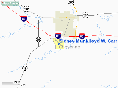
Sidney Muni/lloyd W. Carr Field Airport |
Sidney Municipal Airport
Lloyd W. Carr Field |
| IATA: SNY – ICAO: KSNY – FAA LID: SNY |
| Summary |
| Airport type |
Public |
| Owner |
Sidney Airport Authority |
| Serves |
Sidney, Nebraska |
| Elevation AMSL |
4,313 ft / 1,315 m |
| Coordinates |
41°05′59″N 102°59′06″W / 41.09972°N 102.985°W / 41.09972; -102.985Coordinates: 41°05′59″N 102°59′06″W / 41.09972°N 102.985°W / 41.09972; -102.985 |
| Runways |
| Direction |
Length |
Surface |
| ft |
m |
| 13/31 |
6,600 |
2,012 |
Concrete |
| 3/21 |
4,700 |
1,433 |
Turf |
| Statistics (2006) |
| Aircraft operations |
11,475 |
| Based aircraft |
32 |
| Source: Federal Aviation Administration |
Sidney Municipal Airport (IATA: SNY, ICAO: KSNY, FAA LID: SNY), also known as Lloyd W. Carr Field, is a public use airport located three nautical miles (6 km) south of the central business district of Sidney, a city in Cheyenne County, Nebraska, United States. It is owned by the Sidney Airport Authority.
Facilities and aircraft
Sidney Municipal Airport covers an area of 732 acres (296 ha) at an elevation of 4,313 feet (1,315 m) above mean sea level. It has two runways: 13/31 with a 6,600 x 100 ft (2,012 x 30 m) concrete pavement and 3/21 with a 4,700 x 75 ft (1,433 x 23 m) turf surface.
For the 12-month period ending August 1, 2006, the airport had 11,475 aircraft operations, an average of 31 per day: 90% general aviation, 8% air taxi and 3% military. At that time there were 32 aircraft based at this airport: 88% single-engine, 6% jet, 3% helicopter and 3% ultralight.
The above content comes from Wikipedia and is published under free licenses – click here to read more.
Location & QuickFacts
| FAA Information Effective: | 2008-09-25 |
| Airport Identifier: | SNY |
| Airport Status: | Operational |
| Longitude/Latitude: | 102-59-05.8999W/41-05-59.3052N
-102.984972/41.099807 (Estimated) |
| Elevation: | 4313 ft / 1314.60 m (Surveyed) |
| Land: | 732 acres |
| From nearest city: | 3 nautical miles S of Sidney, NE |
| Location: | Cheyenne County, NE |
| Magnetic Variation: | 11E (1980) |
Owner & Manager
| Ownership: | Publicly owned |
| Owner: | Sidney Airport Authority |
| Address: | Po Box 490
Sidney, NE 69162 |
| Phone number: | 308-254-7898 |
| Manager: | Edwin L. Nelson
HAROLD PERKINS; CHAIRMAN ARPT AUTH; (308) 254-7898. |
| Address: | Po Box 490
Sidney, NE 69162 |
| Phone number: | 308-254-5668 |
Airport Operations and Facilities
| Airport Use: | Open to public |
| Wind indicator: | Yes |
| Segmented Circle: | Yes |
| Control Tower: | No |
| Lighting Schedule: | DUSK-DAWN
ACTVT HIRL RY 13/31 & REIL RYS 13 & 31 - CTAF. |
| Beacon Color: | Clear-Green (lighted land airport) |
| Landing fee charge: | No |
| Sectional chart: | Cheyenne |
| Region: | ACE - Central |
| Boundary ARTCC: | ZDV - Denver |
| Tie-in FSS: | OLU - Columbus |
| FSS on Airport: | No |
| FSS Toll Free: | 1-800-WX-BRIEF |
| NOTAMs Facility: | SNY (NOTAM-d service avaliable) |
| Federal Agreements: | NGVY |
Airport Communications
| CTAF: | 122.800 |
| Unicom: | 122.800 |
Airport Services
| Fuel available: | 100LLA |
| Airframe Repair: | MAJOR |
| Power Plant Repair: | MINOR |
| Bottled Oxygen: | NONE |
| Bulk Oxygen: | NONE |
Runway Information
Runway 03/21
| Dimension: | 4700 x 75 ft / 1432.6 x 22.9 m |
| Surface: | TURF, Good Condition |
| |
Runway 03 |
Runway 21 |
| Longitude: | 102-59-22.4600W | 102-58-46.1577W |
| Latitude: | 41-05-32.9300N | 41-06-10.3786N |
| Elevation: | 4295.00 ft | 4282.00 ft |
| Alignment: | 36 | 127 |
| Traffic Pattern: | Left | Left |
| Obstruction: | 26 ft pline, 640.0 ft from runway, 20:1 slope to clear | 9 ft hill, 366.0 ft from runway, 40:1 slope to clear |
|
Runway 13/31
| Dimension: | 6600 x 100 ft / 2011.7 x 30.5 m |
| Surface: | CONC, Good Condition |
| Weight Limit: | Single wheel: 32000 lbs.
Dual wheel: 52000 lbs.
Dual tandem wheel: 96000 lbs. |
| Edge Lights: | High |
| |
Runway 13 |
Runway 31 |
| Longitude: | 102-59-37.5400W | 102-58-36.5260W |
| Latitude: | 41-06-27.7780N | 41-05-41.7290N |
| Elevation: | 4313.00 ft | 4281.00 ft |
| Alignment: | 127 | 127 |
| Traffic Pattern: | Left | Left |
| Markings: | Non-precision instrument, Good Condition | Non-precision instrument, Good Condition |
| Crossing Height: | 44.00 ft | 47.00 ft |
| VASI: | 2-light PAPI on left side | 2-light PAPI on left side |
| Visual Glide Angle: | 3.00° | 3.00° |
| Runway End Identifier: | Yes | Yes |
|
Radio Navigation Aids
| ID |
Type |
Name |
Ch |
Freq |
Var |
Dist |
| CNP | NDB | Chappell | | 383.00 | 10E | 23.9 nm |
| IBM | NDB | Kimball | | 317.00 | 10E | 31.5 nm |
| OKS | NDB | Oshkosh | | 233.00 | 09E | 33.9 nm |
| BAJ | NDB | Batten | | 392.00 | 11E | 35.9 nm |
| HEQ | NDB | Heginbotham | | 404.00 | 11E | 44.7 nm |
| SNY | VORTAC | Sidney | 106X | 115.90 | 13E | 0.2 nm |
Images and information placed above are from
http://www.airport-data.com/airport/SNY/
We thank them for the data!
| General Info
|
| Country |
United States
|
| State |
NEBRASKA
|
| FAA ID |
SNY
|
| Latitude |
41-06-04.800N
|
| Longitude |
102-59-07.000W
|
| Elevation |
4313 feet
|
| Near City |
SIDNEY
|
We don't guarantee the information is fresh and accurate. The data may
be wrong or outdated.
For more up-to-date information please refer to other sources.
|
|


