|
 |
|
||||
|
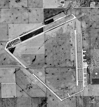
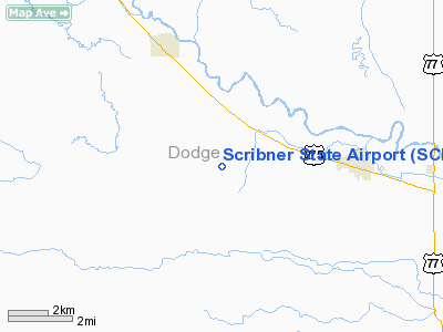
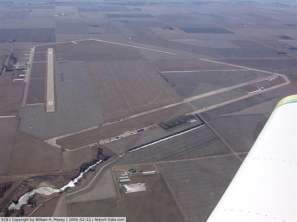
Scribner State Airport (IATA: SCB, ICAO: KSCB, FAA LID: SCB) is a public use airport located three nautical miles (6 km) southeast of the central business district of Scribner, a city in Dodge County, Nebraska, United States. It is owned by the Nebraska Department of Aeronautics. In addition to being a civilian airport, the airfield hosts the IHRA drag racing circuit. Facilities and aircraftScribner State Airport covers an area of 789 acres (319 ha) at an elevation of 1,325 feet (404 m) above mean sea level. It has two runways with concrete surfaces: 17/35 is 4,200 by 75 feet (1,280 x 23 m) and 12/30 is 3,199 by 60 feet (975 x 18 m). For the 12-month period ending August 22, 2007, the airport had 2,600 aircraft operations, an average of 216 per month: 96% general aviation and 4% military. At that time there were 21 aircraft based at this airport: 67% single-engine and 33% ultralight. HistoryScribner State Airport was constructed in 1942 as a United States Army Air Forces military training airfield. The 2,060 acre site is located south of the Elkhorn River and is surrounded by low rolling hills on the east, north and west. Agriculture is the main industry of the area. The first official news that Scribner Army Airfield would be constructed came on 1 October 1942, with eviction notices given to area farmers shortly thereafter. Construction soon began, with two runways completed by 26 November 1942. 87 buildings and structures were constructed. The base was officially opened on 9 December 1942 Scribner AAF was one of eleven training airfields in Nebraska, and came under the command of Second Air Force. It was initially designated as a satellite base to Sioux City Army Air Base, Iowa, though by 1943 it became an independent base, with Ainsworth Army Airfield, Nebraska, being designated as Scribner's satellite. The 4316th Army Air Force Base Unit had host unit responsibilities at Schribner. In December 1942, the Base Commander was Major A. J. Guffanti. The field's primary mission was to provide aircrew training for B-17 Flying Fortress and B-24 Liberator bomber air crews. In addition, P-47 Thunderbolt fighter pilots completed proficiency training at Scribner before reassignment to the European Theater of Operations. Crews that used Scribner Army Airfield included the following:
Schribner also became a camouflage school. By 1943 the entire airfield was camouflaged to look like a farm and small village to prove that an airfield could be hidden from the enemy. The hangar was painted red to resemble a barn, chicken wire was stuffed with green colored spun glass to resemble trees, and a mock silo beside the barn really housed the sliding hangar doors. Another building was given a steeple and painted to resemble a church, and a "school house" was built with spun-glass children. Even the runways were coated with tar and coated with wood chips and ground corncobs, and painted green or brown, depending on the season. The USAAF training airfield closed on 31 December 1945 and the State of Nebraska acquired the Airfield property from the U.S. Government in 1946. By 1951, word came that the then surplus Scribner Air Base was being considered as the site of a proposed United States Air Force Academy. This did not happen, however, the U.S. Air Force acquired 136 acres for installation of an ionosphere sounding station. The detachment operated until 30 April 1959, when it was discontinued. The remainder of the former Airfield was rented out. Nebraska Department of Aeronautics continues to operate the airfield, leasing storage and small segments of land to local concerns. A United States Air Force communications center is also located on the site. Scribner State Airfield currently has two active runways. A few wartime buildings still are in use, along with the remains of the wartime runways, one of which is partially used as a IHRA drag strip. The above content comes from Wikipedia and is published under free licenses – click here to read more.
Location & QuickFacts
Owner & Manager
Airport Operations and Facilities
Airport Communications
Airport Services
Runway InformationRunway 12/30
Runway 17/35
Radio Navigation Aids
Images and information placed above are from We thank them for the data!
We don't guarantee the information is fresh and accurate. The data may
be wrong or outdated.
|
||||||||||||||||||||||||||||||||||||||||||||||||||||||||||||||||||||||||||||||||||||||||||||||||||||||||||||||||||||||||||||||||||||||||||||||||||||||||||||||||||||||||||||||||||||||||||||||||||||||||||||||||||||||||||||||||||||||||||||||||||||||||||||||||||||||||||||||||||||||||||||||||||||||||||||||||||||||||||||||||||||||||||||||||||||||||||||||||||||||||||||||||||||||||||||||||||||||||||||||||

 |
|
Copyright 2004-2026 © by Airports-Worldwide.com, Vyshenskoho st. 36, Lviv 79010, Ukraine Legal Disclaimer |