 |
|
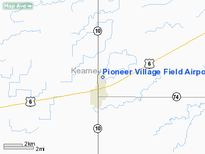
Pioneer Village Field Airport |
Location & QuickFacts
| FAA Information Effective: | 2008-09-25 |
| Airport Identifier: | 0V3 |
| Airport Status: | Operational |
| Longitude/Latitude: | 098-56-44.3000W/40-30-53.7000N
-98.945639/40.514917 (Estimated) |
| Elevation: | 2160 ft / 658.37 m (Surveyed) |
| Land: | 203 acres |
| From nearest city: | 1 nautical miles NE of Minden, NE |
| Location: | Kearney County, NE |
| Magnetic Variation: | 07E (2000) |
Owner & Manager
| Ownership: | Publicly owned |
| Owner: | Minden Airport Authority |
| Address: | P.o. Box 295
Minden, NE 68959-0295 |
| Phone number: | 308-832-0853 |
| Manager: | Chuck Jacobsen
FOR SVC CONTACT CHUCK 308-830-2727. |
| Address: | 355 E 21 Cul De Sac
Minden, NE 68959-2901 |
| Phone number: | 308-830-2727 |
Airport Operations and Facilities
| Airport Use: | Open to public |
| Wind indicator: | Yes |
| Segmented Circle: | Yes |
| Control Tower: | No |
| Lighting Schedule: | DUSK-DAWN
ACTVT MIRL RY 16/34 AND PAPI RYS 16 & 34 - CTAF. |
| Beacon Color: | Clear-Green (lighted land airport) |
| Landing fee charge: | No |
| Sectional chart: | Omaha |
| Region: | ACE - Central |
| Boundary ARTCC: | ZMP - Minneapolis |
| Tie-in FSS: | OLU - Columbus |
| FSS on Airport: | No |
| FSS Toll Free: | 1-800-WX-BRIEF |
| NOTAMs Facility: | OLU (NOTAM-d service avaliable) |
| Federal Agreements: | NGY |
Airport Communications
| CTAF: | 122.700 |
| Unicom: | 122.700 |
Airport Services
| Fuel available: | 100LLMOGAS |
| Bottled Oxygen: | NONE |
| Bulk Oxygen: | NONE |
Runway Information
Runway 05/23
| Dimension: | 1275 x 300 ft / 388.6 x 91.4 m |
| Surface: | TURF, Good Condition |
| |
Runway 05 |
Runway 23 |
| Longitude: | 098-56-49.4460W | 098-56-35.2930W |
| Latitude: | 40-30-55.5650N | 40-31-02.0500N |
| Elevation: | 2154.00 ft | 2155.00 ft |
| Alignment: | 59 | 127 |
| Traffic Pattern: | Left | Left |
| Obstruction: | 30 ft tree, 708.0 ft from runway, 205 ft right of centerline, 20:1 slope to clear | 4 ft fence, 75.0 ft from runway, 20:1 slope to clear |
|
Runway 16/34
| Dimension: | 3900 x 60 ft / 1188.7 x 18.3 m |
| Surface: | CONC, Good Condition |
| Weight Limit: | Single wheel: 30000 lbs.
Dual wheel: 52000 lbs. |
| Edge Lights: | Medium |
| |
Runway 16 |
Runway 34 |
| Longitude: | 098-56-50.9101W | 098-56-39.0662W |
| Latitude: | 40-31-10.7419N | 40-30-33.2791N |
| Elevation: | 2156.00 ft | 2153.00 ft |
| Alignment: | 127 | 127 |
| Traffic Pattern: | Left | Right |
| Markings: | Non-precision instrument, Good Condition | Non-precision instrument, Good Condition |
| Crossing Height: | 40.00 ft | 40.00 ft |
| VASI: | 2-light PAPI on left side | 2-light PAPI on left side |
| Visual Glide Angle: | 3.00° | 3.00° |
| Obstruction: | 5 ft fence, 300.0 ft from runway, 20:1 slope to clear | 25 ft trees, 700.0 ft from runway, 300 ft right of centerline, 20:1 slope to clear |
|
Radio Navigation Aids
| ID |
Type |
Name |
Ch |
Freq |
Var |
Dist |
| HDE | NDB | Holdrege | | 396.00 | 07E | 18.5 nm |
| PSS | NDB | Prosser | | 338.00 | 07E | 23.7 nm |
| RRX | NDB | Darr | | 326.00 | 07E | 46.0 nm |
| EAR | VOR | Kearney | | 111.20 | 10E | 13.0 nm |
| HSI | VOR/DME | Hastings | 025X | 108.80 | 07E | 24.2 nm |
| GRI | VORTAC | Grand Island | 057X | 112.00 | 07E | 40.3 nm |
Remarks
- TWR 1163' AGL, 3240' MSL 9 NM ENE.
- RY 05 CLSD FOR TKOFS.
- ULTRALIGHT ACTIVITY ON AND INVOF ARPT.
Images and information placed above are from
http://www.airport-data.com/airport/0V3/
We thank them for the data!
| General Info
|
| Country |
United States
|
| State |
NEBRASKA
|
| FAA ID |
0V3
|
| Latitude |
40-30-53.685N
|
| Longitude |
098-56-44.343W
|
| Elevation |
2160 feet
|
| Near City |
MINDEN
|
We don't guarantee the information is fresh and accurate. The data may
be wrong or outdated.
For more up-to-date information please refer to other sources.
|
|


