 |
|
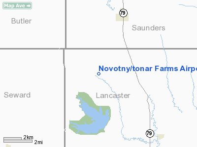
Novotny/tonar Farms Airport |
Location & QuickFacts
| FAA Information Effective: | 2008-09-25 |
| Airport Identifier: | NE88 |
| Airport Status: | Operational |
| Longitude/Latitude: | 096-51-51.0760W/41-01-15.0190N
-96.864188/41.020839 (Estimated) |
| Elevation: | 1426 ft / 434.64 m (Surveyed) |
| Land: | 0 acres |
| From nearest city: | 5 nautical miles W of Valparaiso, NE |
| Location: | Lancaster County, NE |
| Magnetic Variation: | 06E (1985) |
Owner & Manager
| Ownership: | Privately owned |
| Owner: | Thomas Novotny |
| Address: | Rt 1, Box 37
Valparaiso, NE 68065 |
| Phone number: | 402-784-2257 |
| Address: |
|
Airport Operations and Facilities
| Airport Use: | Private |
| Wind indicator: | Yes |
| Segmented Circle: | No |
| Control Tower: | No |
| Lighting Schedule: | PHONE REQ
FOR RWY LGTS CALL 402-784-2257. |
| Landing fee charge: | No |
| Sectional chart: | Omaha |
| Region: | ACE - Central |
| Boundary ARTCC: | ZMP - Minneapolis |
| Tie-in FSS: | OLU - Columbus |
| FSS on Airport: | No |
| FSS Toll Free: | 1-800-WX-BRIEF |
Airport Services
| Fuel available: | 100 |
| Airframe Repair: | NONE |
| Power Plant Repair: | NONE |
Runway Information
Runway N/S
| Dimension: | 2000 x 100 ft / 609.6 x 30.5 m |
| Surface: | TURF, |
| Edge Lights: | Low |
| |
Runway N |
Runway S |
| Traffic Pattern: | Left | Left |
|
Radio Navigation Aids
| ID |
Type |
Name |
Ch |
Freq |
Var |
Dist |
| SWT | NDB | Seward | | 269.00 | 06E | 14.8 nm |
| LN | NDB | Potts | | 385.00 | 06E | 17.1 nm |
| AHQ | NDB | Wahoo | | 400.00 | 07E | 17.8 nm |
| FET | NDB | Fremont | | 311.00 | 06E | 30.2 nm |
| JYR | NDB | York | | 257.00 | 06E | 35.0 nm |
| MLE | NDB | Millard | | 371.00 | 06E | 35.5 nm |
| PLT | NDB | Platte Center | | 407.00 | 08E | 36.9 nm |
| BJU | NDB | Big Blue | | 248.00 | 06E | 39.6 nm |
| FMZ | NDB | Beklof | | 392.00 | 07E | 41.2 nm |
| PMV | NDB | Plattsmouth | | 329.00 | 06E | 43.4 nm |
| HWB | NDB | Shaw | | 263.00 | 06E | 45.7 nm |
| OM | NDB | Gerfi | | 320.00 | 05E | 46.0 nm |
| OFF | TACAN | Offutt | 054X | | 05E | 44.1 nm |
| BIE | VOR | Beatrice | | 110.60 | 07E | 43.5 nm |
| OLU | VOR/DME | Columbus | 055X | 111.80 | 08E | 33.6 nm |
| SCB | VOR/DME | Scribner | 47X | 111.00 | 06E | 36.7 nm |
| LNK | VORTAC | Lincoln | 108X | 116.10 | 09E | 8.0 nm |
| OMA | VOT | Omaha | | 109.00 | | 47.2 nm |
Images and information placed above are from
http://www.airport-data.com/airport/NE88/
We thank them for the data!
| General Info
|
| Country |
United States
|
| State |
NEBRASKA
|
| FAA ID |
NE88
|
| Latitude |
41-01-15.019N
|
| Longitude |
096-51-51.076W
|
| Elevation |
1426 feet
|
| Near City |
VALPARAISO
|
We don't guarantee the information is fresh and accurate. The data may
be wrong or outdated.
For more up-to-date information please refer to other sources.
|
|


