 |
|
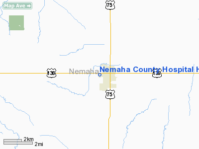
Nemaha County Hospital Heliport |
Location & QuickFacts
| FAA Information Effective: | 2008-09-25 |
| Airport Identifier: | 77NE |
| Airport Status: | Operational |
| Longitude/Latitude: | 095-51-09.9910W/40-23-29.0000N
-95.852775/40.391389 (Estimated) |
| Elevation: | 1085 ft / 330.71 m (Estimated) |
| Land: | 0 acres |
| From nearest city: | 0 nautical miles N of Auburn, NE |
| Location: | Nemaha County, NE |
| Magnetic Variation: | 06E (1985) |
Owner & Manager
| Ownership: | Publicly owned |
| Owner: | Nemaha County Hospital |
| Address: | 2022 13th St
Auburn, NE 68305 |
| Phone number: | 402-274-4366 |
| Manager: | Patrick Lahey |
| Address: | Nemaha County Hospital, 2022 13th St
Auburn, NE 68305 |
| Phone number: | 402-274-4366 |
Airport Operations and Facilities
| Airport Use: | Private
MEDICAL. |
| Wind indicator: | Yes |
| Segmented Circle: | No |
| Control Tower: | No |
| Sectional chart: | Omaha |
| Region: | ACE - Central |
| Boundary ARTCC: | ZMP - Minneapolis |
| Tie-in FSS: | OLU - Columbus |
| FSS Toll Free: | 1-800-WX-BRIEF |
Runway Information
Helipad H1
| Dimension: | 30 x 30 ft / 9.1 x 9.1 m |
| Surface: | CONC, |
| |
Runway H1 |
Runway |
| Traffic Pattern: | Left | Left |
|
Radio Navigation Aids
| ID |
Type |
Name |
Ch |
Freq |
Var |
Dist |
| AYB | NDB | Auburn | | 430.00 | 05E | 3.4 nm |
| AFK | NDB | Nebraska City | | 347.00 | 05E | 12.9 nm |
| FNB | NDB | Brenner | | 404.00 | 05E | 22.5 nm |
| SDA | NDB | Shenandoah | | 411.00 | 05E | 29.7 nm |
| PMV | NDB | Plattsmouth | | 329.00 | 06E | 33.3 nm |
| HWB | NDB | Shaw | | 263.00 | 06E | 42.1 nm |
| ICL | NDB | Clarinda | | 353.00 | 04E | 42.7 nm |
| EVU | NDB | Emville | | 317.00 | 05E | 43.0 nm |
| BJU | NDB | Big Blue | | 248.00 | 06E | 44.0 nm |
| RDK | NDB | Red Oak | | 230.00 | 04E | 46.4 nm |
| LN | NDB | Potts | | 385.00 | 06E | 46.7 nm |
| MYZ | NDB | Marysville | | 341.00 | 06E | 48.3 nm |
| MLE | NDB | Millard | | 371.00 | 06E | 49.7 nm |
| OFF | TACAN | Offutt | 054X | | 05E | 43.7 nm |
| BIE | VOR | Beatrice | | 110.60 | 07E | 41.7 nm |
| RBA | VOR/DME | Robinson | 019X | 108.20 | 04E | 38.0 nm |
| PWE | VORTAC | Pawnee City | 071X | 112.40 | 05E | 19.9 nm |
| OVR | VORTAC | Omaha | 110X | 116.30 | 08E | 46.9 nm |
| STJ | VORTAC | St Joseph | 102X | 115.50 | 08E | 49.9 nm |
Remarks
- PRVDD APCH/DEP PATHS ARE A MINIMUM 8:1 GS & TRANSITIONAL SFCS FOR A 2:1 SLOPE;TREE 40' NE IS REMOVED
Images and information placed above are from
http://www.airport-data.com/airport/77NE/
We thank them for the data!
| General Info
|
| Country |
United States
|
| State |
NEBRASKA
|
| FAA ID |
77NE
|
| Latitude |
40-23-29.000N
|
| Longitude |
095-51-09.991W
|
| Elevation |
1085 feet
|
| Near City |
AUBURN
|
We don't guarantee the information is fresh and accurate. The data may
be wrong or outdated.
For more up-to-date information please refer to other sources.
|
|


