 |
|
| McCook Regional Airport |
| IATA: MCK – ICAO: KMCK – FAA LID: MCK |
| Summary |
| Airport type |
Public |
| Owner |
City of McCook |
| Serves |
McCook, Nebraska |
| Elevation AMSL |
2,583 ft / 787 m |
| Coordinates |
40°12′23″N 100°35′32″W / 40.20639°N 100.59222°W / 40.20639; -100.59222 |
| Runways |
| Direction |
Length |
Surface |
| ft |
m |
| 12/30 |
6,449 |
1,966 |
Concrete |
| 4/22 |
4,000 |
1,219 |
Concrete |
| 17/35 |
1,350 |
411 |
Turf |
| Statistics (2009) |
| Aircraft operations |
16,900 |
| Based aircraft |
32 |
| Source: Federal Aviation Administration |
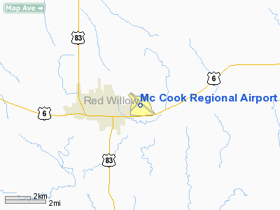
McCook Regional Airport (IATA: MCK, ICAO: KMCK, FAA LID: MCK) is a city-owned, public-use airport located two nautical miles (3.7 km) east of the central business district of the City of McCook, in Red Willow County, Nebraska, United States. It was formerly known as McCook Municipal Airport. The airport is served by one commercial airline, with service subsidized by the Essential Air Service program.
Air Midwest, operating as U.S. Airways Express, commenced service on October 29, 2006, with two daily flights to Grand Island and continuing service to Omaha Eppley Airfield (1 stop) and Kansas City International Airport (2 stops). History
During World War II an even larger training airfield was built some eight miles north of McCook Regional, for the purpose of training of heavy bomber crews. Known, somewhat confusingly, as McCook Army Airfield, the base closed in 1945 and was transferred to state control and renamed McCook State Airfield. It closed for good in 1969 and since has largely reverted to farmland. However the former base's five massive World War II-era hangars are still clearly visible from the air.
Facilities and aircraft
McCook Regional Airport covers an area of 667 acres (270 ha) at an elevation of 2,583 feet (787 m) above mean sea level. It has three runways: 12/30 is 6,449 by 100 feet (1,966 x 30 m) with a concrete surface; 4/22 is 4,000 by 75 feet (1,219 x 23 m) with a concrete surface; 17/35 is 1,350 by 160 feet (411 x 49 m) with a turf surface.
For the 12-month period ending May 31, 2009, the airport had 16,900 aircraft operations, an average of 46 per day: 89% general aviation, 10% scheduled commercial and 1% military. At that time there were 32 aircraft based at this airport: 97% single-engine and 3% multi-engine.
Airlines and destinations
| Airlines |
Destinations |
| Great Lakes Airlines |
Denver, Huron |
The above content comes from Wikipedia and is published under free licenses – click here to read more.
Location & QuickFacts
| FAA Information Effective: | 2008-09-25 |
| Airport Identifier: | MCK |
| Airport Status: | Operational |
| Longitude/Latitude: | 100-35-31.5000W/40-12-22.6000N
-100.592083/40.206278 (Estimated) |
| Elevation: | 2583 ft / 787.30 m (Surveyed) |
| Land: | 667 acres |
| From nearest city: | 2 nautical miles E of Mc Cook, NE |
| Location: | Red Willow County, NE |
| Magnetic Variation: | 08E (1995) |
Owner & Manager
| Ownership: | Publicly owned |
| Owner: | City Of Mc Cook |
| Address: | Box 1059
Mc Cook, NE 69001 |
| Phone number: | 308-345-2022 |
| Manager: | Mr. Kurt Fritsch
CITY MANAGER. |
| Address: | Box 1059
Mc Cook, NE 69001 |
| Phone number: | 308-345-2022 |
Airport Operations and Facilities
| Airport Use: | Open to public |
| Wind indicator: | Yes |
| Segmented Circle: | Yes |
| Control Tower: | No |
| Lighting Schedule: | DUSK-DAWN
ACTVT VASI RY 30 & PAPI RY 12 & MALSR RY 12 - CTAF. |
| Beacon Color: | Clear-Green (lighted land airport) |
| Landing fee charge: | No |
| Sectional chart: | Omaha |
| Region: | ACE - Central |
| Boundary ARTCC: | ZDV - Denver |
| Tie-in FSS: | OLU - Columbus |
| FSS on Airport: | No |
| FSS Toll Free: | 1-800-WX-BRIEF |
| NOTAMs Facility: | MCK (NOTAM-d service avaliable) |
| Certification type/date: | III A S 05/19
AS A CLASS III AIRPORT, ACR OPNS WITH OVER 30 PASS SEATS ARE NOT AUTHORIZE WITHOUT 72 HRS PPR. |
| Federal Agreements: | NGY |
Airport Communications
| CTAF: | 122.800 |
| Unicom: | 122.800 |
Airport Services
| Fuel available: | 100LLA |
| Airframe Repair: | MAJOR |
| Power Plant Repair: | MAJOR |
| Bottled Oxygen: | NONE |
| Bulk Oxygen: | NONE |
Runway Information
Runway 04/22
| Dimension: | 4000 x 75 ft / 1219.2 x 22.9 m |
| Surface: | CONC, Good Condition |
| Weight Limit: | Single wheel: 30000 lbs.
Dual wheel: 38000 lbs. |
| Edge Lights: | Medium |
| |
Runway 04 |
Runway 22 |
| Longitude: | 100-35-58.7363W | 100-35-21.6963W |
| Latitude: | 40-12-10.0562N | 40-12-37.5409N |
| Elevation: | 2563.00 ft | 2556.00 ft |
| Alignment: | 46 | 127 |
| Traffic Pattern: | Right | Left |
| Markings: | Non-precision instrument, Good Condition | Non-precision instrument, Good Condition |
| Crossing Height: | 26.00 ft | 26.00 ft |
| VASI: | 2-box on left side | 2-box on left side |
| Visual Glide Angle: | 3.00° | 3.00° |
| Obstruction: | 25 ft pole, 850.0 ft from runway, 100 ft left of centerline, 26:1 slope to clear | 11 ft tree, 275.0 ft from runway, 250 ft right of centerline, 6:1 slope to clear |
|
Runway 12/30
| Dimension: | 6449 x 100 ft / 1965.7 x 30.5 m |
| Surface: | CONC, Good Condition |
| Weight Limit: | Single wheel: 30000 lbs.
Dual wheel: 38000 lbs. |
| Edge Lights: | Medium |
| |
Runway 12 |
Runway 30 |
| Longitude: | 100-35-57.3722W | 100-34-55.0955W |
| Latitude: | 40-12-44.9779N | 40-12-02.7789N |
| Elevation: | 2583.00 ft | 2542.00 ft |
| Alignment: | 127 | 127 |
| ILS Type: | ILS/DME
| |
| Traffic Pattern: | Left | Right |
| Markings: | Precision instrument, Fair Condition | Non-precision instrument, Fair Condition |
| Crossing Height: | 38.00 ft | 42.00 ft |
| Displaced threshold: | 0.00 ft | 750.00 ft |
| VASI: | 4-light PAPI on left side | 4-box on left side |
| Visual Glide Angle: | 3.00° | 3.00° |
| Approach lights: | MALSR | |
| Runway End Identifier: | | Yes |
| Obstruction: | 30 ft tree, 1225.0 ft from runway, 475 ft left of centerline, 34:1 slope to clear | , 50:1 slope to clear |
| Decleard distances: | Take off run available 6448.00 ft
Take off distance available 6448.00 ft
Actual stop distance available 5698.00 ft
Landing distance available 5698.00 ft
| Take off run available 6448.00 ft
Take off distance available 6448.00 ft
Actual stop distance available 6448.00 ft
Landing distance available 5698.00 ft
|
|
Runway 17/35
| Dimension: | 1350 x 160 ft / 411.5 x 48.8 m |
| Surface: | TURF, Fair Condition |
| |
Runway 17 |
Runway 35 |
| Longitude: | 100-35-30.9432W | 100-35-31.3858W |
| Latitude: | 40-12-19.9162N | 40-12-06.5833N |
| Elevation: | 2558.00 ft | 2560.00 ft |
| Alignment: | 127 | 1 |
| Traffic Pattern: | Left | Right |
|
Radio Navigation Aids
| ID |
Type |
Name |
Ch |
Freq |
Var |
Dist |
| MCK | FAN MARKER | Mc Cook | | | 11E | 2.7 nm |
| CSB | NDB | Harry Strunk | | 389.00 | 08E | 20.8 nm |
| OIN | NDB | Oberlin | | 341.00 | 09E | 22.8 nm |
| ADT | NDB | Atwood | | 365.00 | 09E | 30.4 nm |
| NRN | NDB | Norton | | 230.00 | 08E | 38.6 nm |
| DWL | NDB | Willow | | 353.00 | 08E | 46.6 nm |
| JDM | NDB | Wheatfield | | 408.00 | 08E | 46.8 nm |
| OZB | VOR | Cozad | | 109.00 | 09E | 48.1 nm |
| MCK | VOR/DME | Mc Cook | 100X | 115.30 | 08E | 0.2 nm |
| HCT | VORTAC | Hayes Center | 124X | 117.70 | 11E | 21.3 nm |
Images and information placed above are from
http://www.airport-data.com/airport/MCK/
We thank them for the data!
| General Info
|
| Country |
United States
|
| State |
NEBRASKA
|
| FAA ID |
MCK
|
| Latitude |
40-12-22.600N
|
| Longitude |
100-35-31.500W
|
| Elevation |
2583 feet
|
| Near City |
MC COOK
|
We don't guarantee the information is fresh and accurate. The data may
be wrong or outdated.
For more up-to-date information please refer to other sources.
|
|


