 |
|
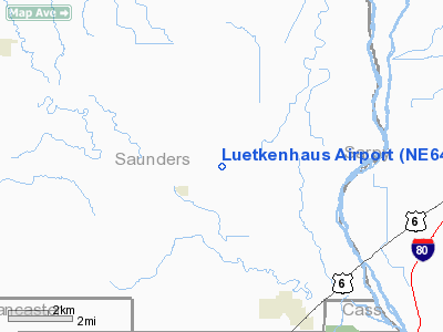
Location & QuickFacts
| FAA Information Effective: | 2008-09-25 |
| Airport Identifier: | NE64 |
| Airport Status: | Operational |
| Longitude/Latitude: | 096-24-34.0580W/41-06-18.9960N
-96.409461/41.105277 (Estimated) |
| Elevation: | 1120 ft / 341.38 m (Estimated) |
| Land: | 0 acres |
| From nearest city: | 1 nautical miles NE of Memphis, NE |
| Location: | Saunders County, NE |
| Magnetic Variation: | 06E (1985) |
Owner & Manager
| Ownership: | Privately owned |
| Owner: | Lorus Luetkenhaus |
| Address: | 630 County Rd D.
Ashland, NE 68003 |
| Phone number: | 402-944-2392 |
| Address: |
|
Airport Operations and Facilities
| Airport Use: | Private |
| Wind indicator: | No |
| Segmented Circle: | No |
| Control Tower: | No |
| Landing fee charge: | No |
| Sectional chart: | Omaha |
| Region: | ACE - Central |
| Boundary ARTCC: | ZMP - Minneapolis |
| Tie-in FSS: | OLU - Columbus |
| FSS on Airport: | No |
| FSS Toll Free: | 1-800-WX-BRIEF |
Airport Services
| Airframe Repair: | NONE |
| Power Plant Repair: | NONE |
Runway Information
Runway N/S
| Dimension: | 1380 x 60 ft / 420.6 x 18.3 m |
| Surface: | TURF, |
| |
Runway N |
Runway S |
| Traffic Pattern: | Right | Right |
| Obstruction: | | 40 ft pline, 1000.0 ft from runway |
|
Radio Navigation Aids
| ID |
Type |
Name |
Ch |
Freq |
Var |
Dist |
| AHQ | NDB | Wahoo | | 400.00 | 07E | 11.7 nm |
| MLE | NDB | Millard | | 371.00 | 06E | 14.4 nm |
| FET | NDB | Fremont | | 311.00 | 06E | 21.3 nm |
| PMV | NDB | Plattsmouth | | 329.00 | 06E | 24.5 nm |
| OM | NDB | Gerfi | | 320.00 | 05E | 25.8 nm |
| LN | NDB | Potts | | 385.00 | 06E | 26.8 nm |
| SWT | NDB | Seward | | 269.00 | 06E | 35.1 nm |
| AFK | NDB | Nebraska City | | 347.00 | 05E | 39.0 nm |
| BJU | NDB | Big Blue | | 248.00 | 06E | 48.2 nm |
| AYB | NDB | Auburn | | 430.00 | 05E | 48.8 nm |
| PLT | NDB | Platte Center | | 407.00 | 08E | 49.8 nm |
| OFF | TACAN | Offutt | 054X | | 05E | 23.1 nm |
| TQE | VOR | Tekamah | | 108.40 | 07E | 40.7 nm |
| SCB | VOR/DME | Scribner | 47X | 111.00 | 06E | 31.6 nm |
| OLU | VOR/DME | Columbus | 055X | 111.80 | 08E | 46.9 nm |
| LNK | VORTAC | Lincoln | 108X | 116.10 | 09E | 18.6 nm |
| OVR | VORTAC | Omaha | 110X | 116.30 | 08E | 30.7 nm |
| OMA | VOT | Omaha | | 109.00 | | 26.3 nm |
Images and information placed above are from
http://www.airport-data.com/airport/NE64/
We thank them for the data!
| General Info
|
| Country |
United States
|
| State |
NEBRASKA
|
| FAA ID |
NE64
|
| Latitude |
41-06-18.996N
|
| Longitude |
096-24-34.058W
|
| Elevation |
1120 feet
|
| Near City |
MEMPHIS
|
We don't guarantee the information is fresh and accurate. The data may
be wrong or outdated.
For more up-to-date information please refer to other sources.
|
|


