|
|
| Lincoln Airport |
 |
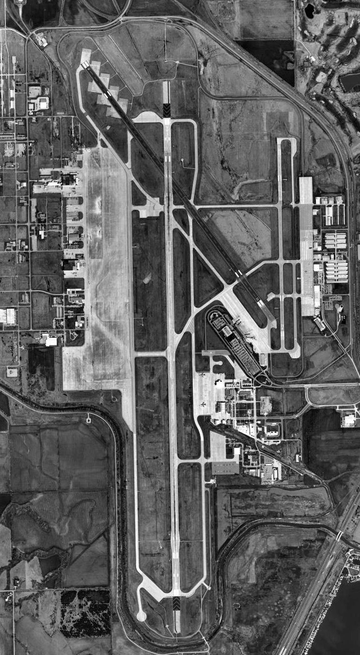
| USGS aerial photo - 4 April 1999 |
| IATA: LNK – ICAO: KLNK – FAA LID: LNK |
| Summary |
| Airport type |
Public / Military |
| Owner |
Lincoln Airport Authority |
| Location |
Lincoln, Nebraska |
| Elevation AMSL |
1,219 ft / 372 m |
| Coordinates |
40°51′04″N 096°45′33″W / 40.85111°N 96.75917°W / 40.85111; -96.75917 |
| Runways |
| Direction |
Length |
Surface |
| ft |
m |
| 18/36 |
12,901 |
3,932 |
Asphalt/Concrete |
| 14/32 |
8,649 |
2,636 |
Asphalt/Concrete |
| 17/35 |
5,400 |
1,646 |
Asphalt/Concrete |
| Statistics (2008) |
| Aircraft operations |
63,021, OPS FOR 12 MOS ENDING 31 March 2009 |
| Based aircraft |
219 |
| Source: Federal Aviation Administration |
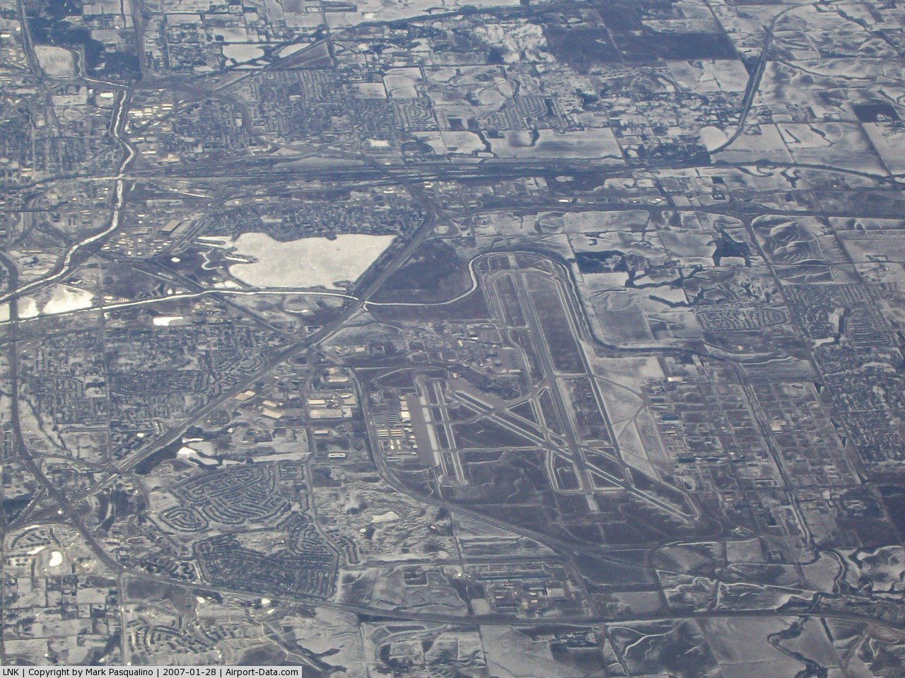
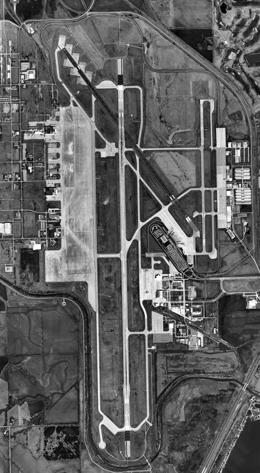
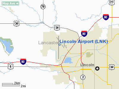
FAA airport diagram Lincoln Airport (IATA: LNK, ICAO: KLNK, FAA LID: LNK), formerly known as Lincoln Municipal Airport, is a joint public/military use airport located four nautical miles (7 km) northwest of the central business district of Lincoln, a city in Lancaster County, Nebraska, United States. It is owned by the Lincoln Airport Authority.
It is the second-largest airport in the state of Nebraska, serving the Lincoln metropolitan area and much of southeastern Nebraska. The airport is located approximately four miles (6.4 km) northwest of downtown Lincoln, on land immediately north and west of Interstate 80.
The long landing strip is now designated as an emergency landing site for the Space Shuttle, though it has never been used in this way. The airport is also home to Duncan Aviation, a large family-owned aircraft maintenance and refurbishing company. Duncan Aviation has several hangars on the east side of the airport, as well as parts storage on the west side. Facilities and aircraft
Lincoln Airport covers an area of 5,000 acres (2,023 ha) at an elevation of 1,219 feet (372 m) above mean sea level. It has three runways with asphalt/concrete surfaces: 18/36 is 12,901 by 200 feet (3,932 x 61 m); 14/32 is 8,649 by 150 feet (2,636 x 46 m); and 17/35 is 5,400 by 100 feet (1,646 x 30 m).
For the 12-month period ending March 31, 2008, the airport had 78,697 aircraft operations, an average of 215 per day: 54% general aviation, 29% military. 12% scheduled commercial and 4% air taxi. At that time there were 219 aircraft based at this airport: 58% single-engine, 21% multi-engine, 7% jet, 2% helicopter and 11% military.
Airlines and destinations
| Airlines |
Destinations |
| Delta Connection operated by Mesaba Airlines |
Minneapolis/St. Paul |
| Delta Connection operated by SkyWest Airlines |
Minneapolis/St. Paul |
| United Express operated by SkyWest Airlines |
Chicago-O'Hare, Denver |
History
During World War II, the airfield was named Lincoln Army Air Field and used for mechanics and flight-crew training. It remained open until December 1945 when it was closed and transferred back to the City of Lincoln.
In 1952 the facility was re-opened as Lincoln Air Force Base. After operating as a Strategic Air Command (SAC) base supporting B-47 Stratojet bombers, KC-97 Stratotanker refueling aircraft and SM-65 Atlas intercontinental ballistic missiles, the U.S. Air Force closed the installation in 1966.
Today, a portion of Lincoln Airport is now home to the Nebraska Air National Guard's 155th Air Refueling Wing (155 ARW), an Air Mobility Command (AMC)-gained Air National Guard unit flying the KC-135R Stratotanker. Several Nebraska Army National Guard units are also collocated at the installation, located just east of Runway 36, alongside Taxiway Delta. The Air National Guard's tarmac is closed to general aviation and is guarded by Air Force Security Forces 24 hours a day.
The airport's main runway is also an alternative landing site for NASA's Space Shuttle orbiter.
The above content comes from Wikipedia and is published under free licenses – click here to read more.
 |
(Click on the photo to enlarge) |
Location & QuickFacts
| FAA Information Effective: | 2008-09-25 |
| Airport Identifier: | LNK |
| Airport Status: | Operational |
| Longitude/Latitude: | 096-45-33.3000W/40-51-03.5000N
-96.759250/40.850972 (Estimated) |
| Elevation: | 1219 ft / 371.55 m (Surveyed) |
| Land: | 5000 acres |
| From nearest city: | 4 nautical miles NW of Lincoln, NE |
| Location: | Lancaster County, NE |
| Magnetic Variation: | 06E (1985) |
Owner & Manager
| Ownership: | Publicly owned |
| Owner: | Lincoln Arpt Auth |
| Address: | Box 80407
Lincoln, NE 68501 |
| Phone number: | 402-458-2400 |
| Manager: | John Wood
ARPT DIRECTOR. |
| Address: | Box 80407
Lincoln, NE 68501 |
| Phone number: | 402-458-2400 |
Airport Operations and Facilities
| Airport Use: | Open to public |
| Wind indicator: | Yes |
| Segmented Circle: | No |
| Control Tower: | Yes |
| Lighting Schedule: | DUSK-DAWN
WHEN ATCT CLSD MIRL RY 14/32 PRESET ON LOW INTST; HIRL RYS 18/36 & 17/35 PRESET ON MED INTST; ODALS RY 35 OPERATE CONTINUOUSLY ON MED INTST; MALSR RYS 18 & 36 OPERATE CONTINUOUSLY & REIL RYS 14 & 17 OPERATE CONTINUOUSLY ON LOW INTST. VASI RYS 14 & 32; PAPI RYS 17, 35, 18 & 36 ON CONTINUOUSLY. |
| Beacon Color: | Clear-Green (lighted land airport) |
| Landing fee charge: | No |
| Sectional chart: | Omaha |
| Region: | ACE - Central |
| Traffic Pattern Alt: | 1000 ft |
| Boundary ARTCC: | ZMP - Minneapolis |
| Tie-in FSS: | OLU - Columbus |
| FSS on Airport: | No |
| FSS Toll Free: | 1-800-WX-BRIEF |
| NOTAMs Facility: | LNK (NOTAM-d service avaliable) |
| Certification type/date: | I B S 05/1973
INDEX C LEVEL ARFF EQUIPMENT PRVDD. |
| Federal Agreements: | NGPY |
Airport Communications
| CTAF: | 118.500 |
| Unicom: | 122.950 |
Airport Services
| Fuel available: | 100LLA |
| Airframe Repair: | MAJOR |
| Power Plant Repair: | MAJOR |
| Bottled Oxygen: | HIGH/LOW |
| Bulk Oxygen: | HIGH |
Runway Information
Runway 14/32
| Dimension: | 8649 x 150 ft / 2636.2 x 45.7 m |
| Surface: | ASPH-CONC, Good Condition |
| Surface Treatment: | Saw-cut or plastic Grooved |
| Weight Limit: | Single wheel: 80000 lbs.
Dual wheel: 170000 lbs.
Dual tandem wheel: 280000 lbs. |
| Edge Lights: | Medium |
| |
Runway 14 |
Runway 32 |
| Longitude: | 096-46-10.8311W | 096-45-06.3305W |
| Latitude: | 40-52-02.2965N | 40-50-52.2645N |
| Elevation: | 1198.00 ft | 1177.00 ft |
| Alignment: | 127 | 127 |
| Traffic Pattern: | Left | Left |
| Markings: | Non-precision instrument, Good Condition | Non-precision instrument, Good Condition |
| Crossing Height: | 48.00 ft | 50.00 ft |
| Displaced threshold: | 363.00 ft | 470.00 ft |
| VASI: | 4-box on left side | 4-box on left side |
| Visual Glide Angle: | 3.00° | 3.00° |
| Runway End Identifier: | Yes | |
| Obstruction: | , 50:1 slope to clear | 59 ft pole, 2475.0 ft from runway, 375 ft right of centerline, 38:1 slope to clear
APCH RATIO FM DSPLCD THR 49:1. |
| Decleard distances: | Take off run available 8649.00 ft
Take off distance available 8649.00 ft
Actual stop distance available 8649.00 ft
Landing distance available 8286.00 ft
| Take off run available 8649.00 ft
Take off distance available 8649.00 ft
Actual stop distance available 8286.00 ft
Landing distance available 7816.00 ft
|
|
Runway 17/35
| Dimension: | 5400 x 100 ft / 1645.9 x 30.5 m |
| Surface: | ASPH-CONC, |
| Surface Treatment: | Aggregate Friction Seal Coat |
| Weight Limit: | Single wheel: 49000 lbs.
Dual wheel: 60000 lbs. |
| Edge Lights: | High |
| |
Runway 17 |
Runway 35 |
| Longitude: | 096-45-02.7133W | 096-45-03.0599W |
| Latitude: | 40-51-40.8311N | 40-50-47.4760N |
| Elevation: | 1219.00 ft | 1176.00 ft |
| Alignment: | 127 | 127 |
| Traffic Pattern: | Left | Right |
| Markings: | Non-precision instrument, Good Condition | Non-precision instrument, Good Condition |
| Crossing Height: | 44.00 ft | 47.00 ft |
| VASI: | 4-light PAPI on left side | 4-light PAPI on left side |
| Visual Glide Angle: | 3.00° | 3.00° |
| Approach lights: | | ODALS |
| Runway End Identifier: | Yes | No |
| Decleard distances: | Take off run available 5400.00 ft
Take off distance available 5400.00 ft
Actual stop distance available 5400.00 ft
Landing distance available 5400.00 ft
| Take off run available 5400.00 ft
Take off distance available 5400.00 ft
Actual stop distance available 5400.00 ft
Landing distance available 5400.00 ft
|
|
Runway 18/36
| Dimension: | 12901 x 200 ft / 3932.2 x 61.0 m |
| Surface: | ASPH-CONC, Good Condition |
| Surface Treatment: | Saw-cut or plastic Grooved |
| Weight Limit: | Single wheel: 100000 lbs.
Dual wheel: 200000 lbs.
Dual tandem wheel: 400000 lbs. |
| Edge Lights: | High |
| |
Runway 18 |
Runway 36 |
| Longitude: | 096-45-42.0311W | 096-45-42.8571W |
| Latitude: | 40-51-46.7689N | 40-49-39.3027N |
| Elevation: | 1195.00 ft | 1175.00 ft |
| Alignment: | 127 | 127 |
| ILS Type: | ILS
| ILS
|
| Traffic Pattern: | Right | Left |
| Markings: | Precision instrument, Good Condition | Precision instrument, Good Condition |
| Crossing Height: | 55.00 ft | 57.00 ft |
| VASI: | 4-light PAPI on left side | 4-light PAPI on left side |
| Visual Glide Angle: | 3.00° | 3.00° |
| RVR Equipment: | | touchdown |
| Approach lights: | MALSR | MALSR |
| Decleard distances: | Take off run available 12901.00 ft
Take off distance available 12901.00 ft
Actual stop distance available 12901.00 ft
Landing distance available 12901.00 ft
| Take off run available 12901.00 ft
Take off distance available 12901.00 ft
Actual stop distance available 12901.00 ft
Landing distance available 12901.00 ft
|
|
Radio Navigation Aids
| ID |
Type |
Name |
Ch |
Freq |
Var |
Dist |
| LN | NDB | Potts | | 385.00 | 06E | 6.2 nm |
| SWT | NDB | Seward | | 269.00 | 06E | 16.0 nm |
| AHQ | NDB | Wahoo | | 400.00 | 07E | 24.4 nm |
| BJU | NDB | Big Blue | | 248.00 | 06E | 29.4 nm |
| HWB | NDB | Shaw | | 263.00 | 06E | 35.2 nm |
| MLE | NDB | Millard | | 371.00 | 06E | 35.8 nm |
| FET | NDB | Fremont | | 311.00 | 06E | 37.6 nm |
| PMV | NDB | Plattsmouth | | 329.00 | 06E | 38.9 nm |
| JYR | NDB | York | | 257.00 | 06E | 39.1 nm |
| FMZ | NDB | Beklof | | 392.00 | 07E | 40.0 nm |
| AFK | NDB | Nebraska City | | 347.00 | 05E | 43.5 nm |
| FBY | NDB | Fairbury | | 293.00 | 06E | 44.6 nm |
| OM | NDB | Gerfi | | 320.00 | 05E | 47.8 nm |
| PLT | NDB | Platte Center | | 407.00 | 08E | 47.9 nm |
| OFF | TACAN | Offutt | 054X | | 05E | 42.1 nm |
| BIE | VOR | Beatrice | | 110.60 | 07E | 33.0 nm |
| OLU | VOR/DME | Columbus | 055X | 111.80 | 08E | 44.6 nm |
| SCB | VOR/DME | Scribner | 47X | 111.00 | 06E | 45.7 nm |
| LNK | VORTAC | Lincoln | 108X | 116.10 | 09E | 4.4 nm |
| PWE | VORTAC | Pawnee City | 071X | 112.40 | 05E | 46.6 nm |
| OMA | VOT | Omaha | | 109.00 | | 47.7 nm |
Remarks
- BIRDS INVOF ARPT.
- ANG: CTC HUSKR CON 234.65 20 MIN PRIOR TO LDG.
- RY 32 APCH HOLDLINE ON SOUTH "A" TWY.
- DO NOT MISTAKE PARALLEL TWY 'A' FOR RY 35.
- PAY PARTICULAR ATTENTION WHEN CROSSING RY 17/35 FM THE EAST RAMP. TO CLEAR RY 17/35 SAFETY AREA THE APPROPRIATE STOP POINT IS AT HOLD SIGN FOR RY 32.
- PPR TO PARK ON ARNG RAMP.
- TAXIING ACFT SHOULD USE CAUTION IN EARLY MORNING & LATE AFTERNOON. SUNGLARE MAY MAKE VISUAL RECOGNITION OF SIGNS & MKGS DIFFICULT.
- USE CAUTION, LIMITED SIGHT DISTANCE BETWEEN RY THLDS DUE TO VISUAL OBSTNS.
- RY 18 DESIGNATED CALM WIND RY.
- NSTD MKGS ON TWY 'A' CONSISTS OF A SERPENTINE LINE ALONG THE TWY CNTRLN AT THE RY 32 APCH HOLD LINE & EXTENDING NORTH 850 FT TO TWY 'N'.
Images and information placed above are from
http://www.airport-data.com/airport/LNK/
We thank them for the data!
| General Info
|
| Country |
United States
|
| State |
NEBRASKA
|
| FAA ID |
LNK
|
| Latitude |
40-51-03.500N
|
| Longitude |
096-45-33.300W
|
| Elevation |
1219 feet
|
| Near City |
LINCOLN
|
We don't guarantee the information is fresh and accurate. The data may
be wrong or outdated.
For more up-to-date information please refer to other sources.
|
|