 |
|
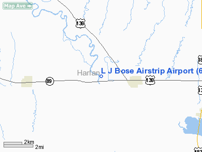
L J Bose Airstrip Airport |
Location & QuickFacts
| FAA Information Effective: | 2008-09-25 |
| Airport Identifier: | 67NE |
| Airport Status: | Operational |
| Longitude/Latitude: | 099-29-54.3750W/40-08-13.0350N
-99.498437/40.136954 (Estimated) |
| Elevation: | 2000 ft / 609.60 m (Estimated) |
| Land: | 10 acres |
| From nearest city: | 2 nautical miles W of Orleans, NE |
| Location: | Harlan County, NE |
| Magnetic Variation: | 08E (1985) |
Owner & Manager
| Ownership: | Privately owned |
| Owner: | L. J. Bose Farms, Inc. |
| Address: | Route 1 Box 132
Orleans, NE 68966 |
| Phone number: | 308-473-3027 |
| Manager: | Royce A. Bose |
| Address: | Rt 1, Box 113-a
Orleans, NE 68966 |
| Phone number: | 308-473-8605 |
Airport Operations and Facilities
| Airport Use: | Private |
| Wind indicator: | Yes |
| Segmented Circle: | No |
| Control Tower: | No |
| Lighting Schedule: | DUSK-DAWN |
| Landing fee charge: | No |
| Sectional chart: | Omaha |
| Region: | ACE - Central |
| Boundary ARTCC: | ZDV - Denver |
| Tie-in FSS: | OLU - Columbus |
| FSS on Airport: | No |
| FSS Toll Free: | 1-800-WX-BRIEF |
Runway Information
Runway 17/35
| Dimension: | 2765 x 93 ft / 842.8 x 28.3 m |
| Surface: | TURF, |
| Edge Lights: | Low |
| |
Runway 17 |
Runway 35 |
| Traffic Pattern: | Left | Left |
| Markings: | Basic, | Basic, |
|
Radio Navigation Aids
| ID |
Type |
Name |
Ch |
Freq |
Var |
Dist |
| MCK | FAN MARKER | Mc Cook | | | 11E | 48.1 nm |
| HDE | NDB | Holdrege | | 396.00 | 07E | 20.1 nm |
| NRN | NDB | Norton | | 230.00 | 08E | 24.7 nm |
| PHG | NDB | Phillipsburg | | 368.00 | 08E | 27.6 nm |
| CSB | NDB | Harry Strunk | | 389.00 | 08E | 31.9 nm |
| RRX | NDB | Darr | | 326.00 | 07E | 45.6 nm |
| EAR | VOR | Kearney | | 111.20 | 10E | 42.0 nm |
| OZB | VOR | Cozad | | 109.00 | 09E | 49.8 nm |
Remarks
- PROVIDED APPROACHES ARE MAINTAINED FOR A 20:1 GLIDE SLOPE AND TRANSITIONAL SURFACES FOR A 7:1 SLOPE.
Images and information placed above are from
http://www.airport-data.com/airport/67NE/
We thank them for the data!
| General Info
|
| Country |
United States
|
| State |
NEBRASKA
|
| FAA ID |
67NE
|
| Latitude |
40-08-13.035N
|
| Longitude |
099-29-54.375W
|
| Elevation |
2000 feet
|
| Near City |
ORLEANS
|
We don't guarantee the information is fresh and accurate. The data may
be wrong or outdated.
For more up-to-date information please refer to other sources.
|
|


