 |
|
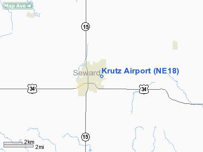
Location & QuickFacts
| FAA Information Effective: | 2008-09-25 |
| Airport Identifier: | NE18 |
| Airport Status: | Operational |
| Longitude/Latitude: | 097-04-50.1170W/40-54-51.0300N
-97.080588/40.914175 (Estimated) |
| Elevation: | 1450 ft / 441.96 m (Estimated) |
| Land: | 0 acres |
| From nearest city: | 1 nautical miles E of Seward, NE |
| Location: | Seward County, NE |
| Magnetic Variation: | 07E (1985) |
Owner & Manager
| Ownership: | Privately owned |
| Owner: | Charles Krutz |
| Address: | 2625 Bluff Rd
Seward, NE 68434 |
| Phone number: | 402-643-3464 |
| Manager: | Charles Krutz |
| Address: | 2625 Bluff Rd
Seward, NE 68434 |
| Phone number: | 402-643-3464 |
Airport Operations and Facilities
| Airport Use: | Private |
| Wind indicator: | Yes |
| Segmented Circle: | No |
| Control Tower: | No |
| Landing fee charge: | No |
| Sectional chart: | Omaha |
| Region: | ACE - Central |
| Boundary ARTCC: | ZMP - Minneapolis |
| Tie-in FSS: | OLU - Columbus |
| FSS on Airport: | No |
| FSS Toll Free: | 1-800-WX-BRIEF |
Airport Services
| Airframe Repair: | NONE |
| Power Plant Repair: | NONE |
Runway Information
Runway 14/32
| Dimension: | 1600 x 80 ft / 487.7 x 24.4 m |
| Surface: | TURF, |
| |
Runway 14 |
Runway 32 |
| Traffic Pattern: | Left | Right |
|
Radio Navigation Aids
| ID |
Type |
Name |
Ch |
Freq |
Var |
Dist |
| SWT | NDB | Seward | | 269.00 | 06E | 3.5 nm |
| LN | NDB | Potts | | 385.00 | 06E | 17.6 nm |
| JYR | NDB | York | | 257.00 | 06E | 24.4 nm |
| AHQ | NDB | Wahoo | | 400.00 | 07E | 29.3 nm |
| FMZ | NDB | Beklof | | 392.00 | 07E | 29.5 nm |
| BJU | NDB | Big Blue | | 248.00 | 06E | 35.3 nm |
| PLT | NDB | Platte Center | | 407.00 | 08E | 37.6 nm |
| FET | NDB | Fremont | | 311.00 | 06E | 41.1 nm |
| HWB | NDB | Shaw | | 263.00 | 06E | 41.7 nm |
| FBY | NDB | Fairbury | | 293.00 | 06E | 44.5 nm |
| MLE | NDB | Millard | | 371.00 | 06E | 46.9 nm |
| BIE | VOR | Beatrice | | 110.60 | 07E | 39.7 nm |
| OLU | VOR/DME | Columbus | 055X | 111.80 | 08E | 34.3 nm |
| SCB | VOR/DME | Scribner | 47X | 111.00 | 06E | 46.3 nm |
| LNK | VORTAC | Lincoln | 108X | 116.10 | 09E | 15.4 nm |
Remarks
-
- PVT USE. PVDD EACH APCH IS MAINT FOR 20:1 GLIDE SLOPE & TRSNL SFC IS MAINT FOR 7:1 SLOPE.
Images and information placed above are from
http://www.airport-data.com/airport/NE18/
We thank them for the data!
| General Info
|
| Country |
United States
|
| State |
NEBRASKA
|
| FAA ID |
NE18
|
| Latitude |
40-54-51.030N
|
| Longitude |
097-04-50.117W
|
| Elevation |
1450 feet
|
| Near City |
SEWARD
|
We don't guarantee the information is fresh and accurate. The data may
be wrong or outdated.
For more up-to-date information please refer to other sources.
|
|


