 |
|
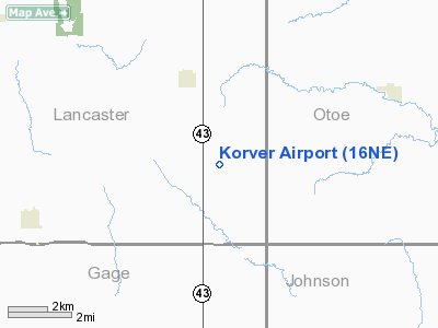
Location & QuickFacts
| FAA Information Effective: | 2008-09-25 |
| Airport Identifier: | 16NE |
| Airport Status: | Operational |
| Longitude/Latitude: | 096-29-30.0540W/40-33-35.9980N
-96.491682/40.559999 (Estimated) |
| Elevation: | 1390 ft / 423.67 m (Estimated) |
| Land: | 0 acres |
| From nearest city: | 3 nautical miles SE of Panama, NE |
| Location: | Lancaster County, NE |
| Magnetic Variation: | 06E (1985) |
Owner & Manager
| Ownership: | Privately owned |
| Owner: | K-l Agri Farms, Inc |
| Address: | 16934 Pella Rd
Adams, NE 68301 |
| Phone number: | 402-788-2572 |
| Manager: | Kelvin M. Korver |
| Address: | 16934 Pella Rd
Adams, NE 68301 |
| Phone number: | 402-432-8975 |
Airport Operations and Facilities
| Airport Use: | Private |
| Wind indicator: | Yes |
| Segmented Circle: | No |
| Control Tower: | No |
| Landing fee charge: | No |
| Sectional chart: | Omaha |
| Region: | ACE - Central |
| Boundary ARTCC: | ZMP - Minneapolis |
| Tie-in FSS: | OLU - Columbus |
| FSS on Airport: | No |
| FSS Toll Free: | 1-800-WX-BRIEF |
Airport Services
| Airframe Repair: | NONE |
| Power Plant Repair: | NONE |
| Bottled Oxygen: | NONE |
| Bulk Oxygen: | NONE |
Runway Information
Runway 18/36
| Dimension: | 4990 x 70 ft / 1521.0 x 21.3 m |
| Surface: | TURF, |
| |
Runway 18 |
Runway 36 |
| Traffic Pattern: | Left | Left |
| Runway End Identifier: | No | No |
| Centerline Lights: | No | No |
| Touchdown Lights: | No | No |
| Obstruction: | 50 ft pline, 200.0 ft from runway | , 990.0 ft from runway |
|
Radio Navigation Aids
| ID |
Type |
Name |
Ch |
Freq |
Var |
Dist |
| LN | NDB | Potts | | 385.00 | 06E | 16.7 nm |
| BJU | NDB | Big Blue | | 248.00 | 06E | 18.8 nm |
| HWB | NDB | Shaw | | 263.00 | 06E | 21.5 nm |
| AFK | NDB | Nebraska City | | 347.00 | 05E | 28.9 nm |
| AYB | NDB | Auburn | | 430.00 | 05E | 32.3 nm |
| SWT | NDB | Seward | | 269.00 | 06E | 33.6 nm |
| PMV | NDB | Plattsmouth | | 329.00 | 06E | 35.0 nm |
| FBY | NDB | Fairbury | | 293.00 | 06E | 38.5 nm |
| AHQ | NDB | Wahoo | | 400.00 | 07E | 41.1 nm |
| MLE | NDB | Millard | | 371.00 | 06E | 41.8 nm |
| MYZ | NDB | Marysville | | 341.00 | 06E | 43.0 nm |
| FMZ | NDB | Beklof | | 392.00 | 07E | 49.2 nm |
| OFF | TACAN | Offutt | 054X | | 05E | 43.0 nm |
| BIE | VOR | Beatrice | | 110.60 | 07E | 19.7 nm |
| LNK | VORTAC | Lincoln | 108X | 116.10 | 09E | 24.7 nm |
| PWE | VORTAC | Pawnee City | 071X | 112.40 | 05E | 25.3 nm |
Remarks
- E111 PRVDD THE APCH TO EACH RWY IS MAINTD FOR A MIN 20:1 GLIDE SLOPE AND THE TRANSITIONAL SFC MAINTD FOR A 7:1 SLOPE.
Images and information placed above are from
http://www.airport-data.com/airport/16NE/
We thank them for the data!
| General Info
|
| Country |
United States
|
| State |
NEBRASKA
|
| FAA ID |
16NE
|
| Latitude |
40-33-35.998N
|
| Longitude |
096-29-30.054W
|
| Elevation |
1390 feet
|
| Near City |
PANAMA
|
We don't guarantee the information is fresh and accurate. The data may
be wrong or outdated.
For more up-to-date information please refer to other sources.
|
|


