 |
|
- This article is about the airport in Kansas. For other uses see Kearny Airport.
| Kearney Regional Airport |
 |
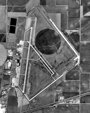 |
| USGS aerial photo - 6 Apr 1999 |
| IATA: EAR – ICAO: KEAR – FAA LID: EAR |
| Summary |
| Airport type |
Public |
| Owner |
City of Kearney |
| Serves |
Kearney, Nebraska |
| Location |
Center Township, Buffalo County, near Kearney, Nebraska |
| Elevation AMSL |
2,131 ft / 650 m |
| Coordinates |
40°43′37″N 099°00′24″W / 40.72694°N 99.00667°W / 40.72694; -99.00667 |
| Website |
www.FlyKearney.org |
| Runways |
| Direction |
Length |
Surface |
| ft |
m |
| 18/36 |
7,094 |
2,162 |
Asphalt |
| 13/31 |
4,498 |
1,371 |
Concrete |
| Statistics (2008) |
| Aircraft operations |
30,040 |
| Based aircraft |
29 |
| Source: Federal Aviation Administration |
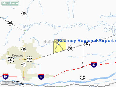
Kearney Regional Airport (IATA: EAR, ICAO: KEAR, FAA LID: EAR), formerly known as Kearney Municipal Airport, is a public airport located four nautical miles (7 km) northeast of the central business district of Kearney, a city in Buffalo County, Nebraska, United States. The airport is owned by the City of Kearney. It is served by one commercial airline, with service subsidized by the Essential Air Service program. Facilities and aircraft
Kearney Regional Airport covers an area of 2,500 acres (1,012 ha) at an elevation of 2,131 feet (650 m) above mean sea level. It has two runways: 18/36 with a asphalt pavement measuring 7,094 x 150 ft (2,162 x 46 m) and 13/31 with an concrete surface measuring 4,498 x 75 ft (1,371 x 23 m).
For the 12-month period ending September 30, 2008, the airport had 30,040 aircraft operations, an average of 82 per day: 93% general aviation, 5% scheduled commercial, 2% air taxi and <1% military. At that time there were 29 aircraft based at this airport: 83% single-engine, 14% multi-engine and 3% helicopter.
Airlines and destinations
| Airlines |
Destinations |
| Great Lakes Airlines |
Denver |
HistoryIn 1940, Kearney had a population of 9,643 people. In the early 1940s, three Nebraska cities, Kearney, Grand Island and Hastings joined together to form the Central Nebraska Defense Council when it was learned that the United States Army Air Force was considering the site for a military airfield. The group attempted to convince Washington that central Nebraska was a suitable location for defense related activities. Kearney and Grand Island effectively competed with one another as locations for defense airports which would serve as storage for aircraft being produced at Offutt Field and the Glenn L. Martin Bomber Plant near Omaha.
As early as 1941 the City of Kearney voted on a $60,000 bond to finance a new airport. Kearney Regional Airport began as Keens Municipal Airport. The total cost ended up being more than $360,000, with the balance funded by the Works Progress Administration (WPA). Construction began at the site five miles east of Kearney on Highway 30 on 21 October 1941, and was dedicated as Keens Airport on 23 August 1942, with asphalt runways and a single hangar only a handful of buildings from the military era remain at Kearney Airport. The predominant one being Hangar #385.
The above content comes from Wikipedia and is published under free licenses – click here to read more.
Location & QuickFacts
| FAA Information Effective: | 2008-09-25 |
| Airport Identifier: | EAR |
| Airport Status: | Operational |
| Longitude/Latitude: | 099-00-24.4000W/40-43-37.3000N
-99.006778/40.727028 (Estimated) |
| Elevation: | 2131 ft / 649.53 m (Surveyed) |
| Land: | 2500 acres |
| From nearest city: | 4 nautical miles NE of Kearney, NE |
| Location: | Buffalo County, NE |
| Magnetic Variation: | 09E (1980) |
Owner & Manager
| Ownership: | Publicly owned |
| Owner: | City Of Kearney |
| Address: | P.o. Box 1180
Kearney, NE 68848 |
| Phone number: | 308-233-3212 |
| Manager: | James Lynaugh |
| Address: | P.o. Box 1180
Kearney, NE 68848 |
| Phone number: | 308-234-2318 |
Airport Operations and Facilities
| Airport Use: | Open to public |
| Wind indicator: | Yes |
| Segmented Circle: | Yes |
| Control Tower: | No |
| Lighting Schedule: | DUSK-DAWN
HIRL RY 18/36 PRESET ON LOW INTST; TO INCR INTST & ACTVT MIRL RY 13/31; VASI RY 18; PAPI RYS 13; 31 & 36; REIL RY 18 & MALSR RY 36 - CTAF. |
| Beacon Color: | Clear-Green (lighted land airport) |
| Landing fee charge: | No |
| Sectional chart: | Omaha |
| Region: | ACE - Central |
| Boundary ARTCC: | ZMP - Minneapolis |
| Tie-in FSS: | OLU - Columbus |
| FSS on Airport: | No |
| FSS Toll Free: | 1-800-WX-BRIEF |
| NOTAMs Facility: | EAR (NOTAM-d service avaliable) |
| Certification type/date: | III A S 11/20
ARPT CLSD TO ACR OPNS WITH MORE THAN 30 PSGR SEATS. |
| Federal Agreements: | NGPY |
Airport Communications
| CTAF: | 123.000 |
| Unicom: | 123.000 |
Airport Services
| Fuel available: | 100LLA |
| Airframe Repair: | MAJOR |
| Power Plant Repair: | MAJOR |
| Bottled Oxygen: | NONE |
| Bulk Oxygen: | NONE |
Runway Information
Runway 13/31
| Dimension: | 4498 x 75 ft / 1371.0 x 22.9 m |
| Surface: | CONC, Good Condition |
| Weight Limit: | Single wheel: 30000 lbs.
Dual wheel: 38000 lbs. |
| Edge Lights: | Medium |
| |
Runway 13 |
Runway 31 |
| Longitude: | 099-00-31.4640W | 098-59-54.8790W |
| Latitude: | 40-43-56.3250N | 40-43-21.6840N |
| Elevation: | 2128.00 ft | 2128.00 ft |
| Alignment: | 127 | 127 |
| Traffic Pattern: | Left | Left |
| Markings: | Non-precision instrument, Good Condition | Non-precision instrument, Good Condition |
| VASI: | 2-light PAPI on left side | 2-light PAPI on left side |
|
Runway 18/36
| Dimension: | 7094 x 150 ft / 2162.3 x 45.7 m |
| Surface: | ASPH, Good Condition |
| Weight Limit: | Single wheel: 48000 lbs.
Dual wheel: 73000 lbs. |
| Edge Lights: | High |
| |
Runway 18 |
Runway 36 |
| Longitude: | 099-00-25.5380W | 099-00-37.4100W |
| Latitude: | 40-44-11.0440N | 40-43-01.5420N |
| Elevation: | 2128.00 ft | 2131.00 ft |
| Alignment: | 127 | 7 |
| ILS Type: | | ILS/DME
|
| Traffic Pattern: | Left | Left |
| Markings: | Non-precision instrument, Good Condition | Non-precision instrument, Good Condition |
| Crossing Height: | 45.00 ft | 0.00 ft |
| VASI: | 4-box on left side | 4-light PAPI on left side |
| Visual Glide Angle: | 3.00° | 0.00° |
| Approach lights: | | MALSR |
| Runway End Identifier: | Yes | |
| Obstruction: | 103 ft bldg, 5250.0 ft from runway, 49:1 slope to clear | , 50:1 slope to clear |
|
Radio Navigation Aids
| ID |
Type |
Name |
Ch |
Freq |
Var |
Dist |
| HDE | NDB | Holdrege | | 396.00 | 07E | 22.7 nm |
| PSS | NDB | Prosser | | 338.00 | 07E | 24.2 nm |
| RRX | NDB | Darr | | 326.00 | 07E | 39.3 nm |
| DWL | NDB | Willow | | 353.00 | 08E | 49.3 nm |
| EAR | VOR | Kearney | | 111.20 | 10E | 0.1 nm |
| OZB | VOR | Cozad | | 109.00 | 09E | 46.2 nm |
| HSI | VOR/DME | Hastings | 025X | 108.80 | 07E | 27.3 nm |
| GRI | VORTAC | Grand Island | 057X | 112.00 | 07E | 35.0 nm |
| OBH | VORTAC | Wolbach | 095X | 114.80 | 07E | 49.0 nm |
Remarks
- APRON COND GOOD SOME SPALLING IN ISOLATED CONC AREAS.(NOT IN USE FOR ACFT).
Images and information placed above are from
http://www.airport-data.com/airport/EAR/
We thank them for the data!
| General Info
|
| Country |
United States
|
| State |
NEBRASKA
|
| FAA ID |
EAR
|
| Latitude |
40-43-37.300N
|
| Longitude |
099-00-24.400W
|
| Elevation |
2131 feet
|
| Near City |
KEARNEY
|
We don't guarantee the information is fresh and accurate. The data may
be wrong or outdated.
For more up-to-date information please refer to other sources.
|
|


