|
 |
|
||||
|
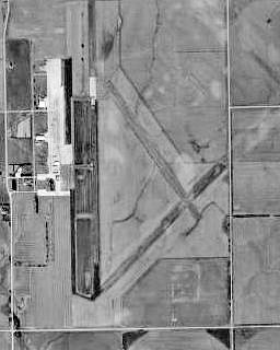
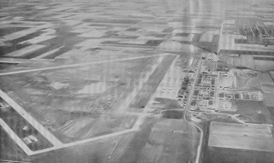
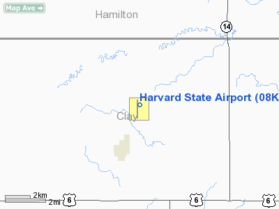
Harvard State Airport (FAA LID: 08K), also known as Harvard State Airfield, is a public use airport located two nautical miles (4 km) northeast of the central business district of Harvard, a city in Clay County, Nebraska, United States. It is owned by the Nebraska Department of Aeronautics. The airport serves the general aviation community, with no scheduled commercial airline service. HistoryHarvard Army Airfield was constructed in 1942 as a United States Army Air Force military training airfield. The site is located in a farming area, and consists of l,704 acres. It was one of eleven training airfields in Nebraska during World War II. On 2 September 1942, an announcement was made to the community of Harvard that a satellite Army Airfield would be located just northeast of Harvard. By September 17 construction began, farmers were removed from their properties, and by November 19, the work was nearly. completed with 277 buildings and structures were constructed. It was a major World War II training center for bomber crews of the 2nd Air Force. Complete engine and air-frame repairs were available for B-17, B-24 and B-29 bombers at the five hangars on the field. Between August 1943 and December 1945, twenty six bombardment squadrons received proficiency training at Harvard AAF The airfield was under the command of Second Air Force Headquarters, Colorado Springs, Colorado. The 521th Army Air Force Base Unit commanded the support elements at Harvard as part of Air Technical Service Command. The 521st was assigned to the 15th Bombardment Training Wing (September 1943 - March 1944), then transferred to the 17th Bombardment Training Wing in March 1944 for B-29 training. The airfield was opened as a satellite base for Kearney AAF, but was soon scheduled for full time operation as independent USAAF airfield. By early 1943, the base was on a 24-hour program of training Boeing B-17 Flying Fortress and Consolidated B-24 Liberator and crews for the European theater against the German Luftwaffe. In March 1944, the Boeing B-29 Superfortress made its way to Harvard Airfield for training. From mid-1944 until May 1946, Super Fortresses from the airfield trained aircrews over Nebraska's countryside before they were sent to the Pacific theater. At its peak, approximately 6,000 officers and enlisted men were stationed at the base for training purposes. In addition, many civilian workers from Harvard and several surrounding communities worked at the base in support of this gigantic training undertaking. Known groups which trained at Harvard were:
Even after the surrender of the Japanese in September 1945, the Harvard base remained active for a period, until the base was finally declared surplus property on 21 May 1946 and turned over to the State of Nebraska. At that time, all Army material was packed and shipped out. Other than the four hangars, most of the buildings, including barracks, gymnasium, picture show, Service Club, chapel, weather station, post exchange and many other building were either moved away or dismantled and sold for the lumber. Most of the area that was once the Harvard Army Airfield has reverted back to agricultural purposes and the hangars are used for grain storage. In 1983, three of the hangars were destroyed by fire, which was started by careless use of a cutting torch by a pair of teenagers who were dismantling the first hangar for salvage. A handful of wartime buildings still exist on the former military airfield. The housing erected by the federal government on the northeast edge of Harvard for personnel stationed at the base, most commonly referred to by Harvardites as "The Courts" or "Courts Addition," has been a residential village for the citizens of Harvard for many years. Facilities and aircraftHarvard State Airport covers an area of 1,102 acres (446 ha) at an elevation of 1,815 feet (553 m) above mean sea level. It has two runways: 17/35 is 3,745 by 60 feet (1,141 x 18 m) with an asphalt pavement; 14/32 is 3,900 by 150 feet (1,189 x 46 m) with an turf surface. For the 12-month period ending July 24, 2008, the airport had 1,570 aircraft operations, an average of 130 per month: 99% general aviation and 1% military. The above content comes from Wikipedia and is published under free licenses – click here to read more.
Location & QuickFacts
Owner & Manager
Airport Operations and Facilities
Airport Communications
Airport Services
Runway InformationRunway 14/32
Runway 17/35
Radio Navigation Aids
Remarks
Images and information placed above are from We thank them for the data!
We don't guarantee the information is fresh and accurate. The data may
be wrong or outdated.
|
||||||||||||||||||||||||||||||||||||||||||||||||||||||||||||||||||||||||||||||||||||||||||||||||||||||||||||||||||||||||||||||||||||||||||||||||||||||||||||||||||||||||||||||||||||||||||||||||||||||||||||||||||||||||||||||||||||||||||||||||||||||||||||||||||||||||||||||||||||||||||||||||||||||||||||||||||||||||||||||||

 |
|
Copyright 2004-2026 © by Airports-Worldwide.com, Vyshenskoho st. 36, Lviv 79010, Ukraine Legal Disclaimer |