 |
|
Location & QuickFacts
| FAA Information Effective: | 2008-09-25 |
| Airport Identifier: | NE46 |
| Airport Status: | Operational |
| Longitude/Latitude: | 096-04-01.0650W/41-15-14.9950N
-96.066963/41.254165 (Estimated) |
| Elevation: | 1150 ft / 350.52 m (Estimated) |
| Land: | 0 acres |
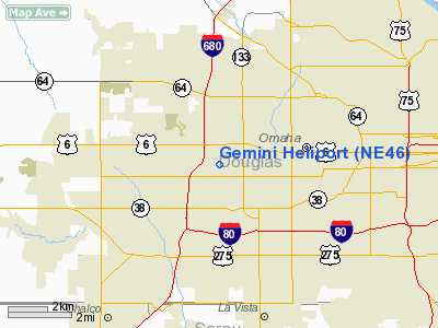
| From nearest city: | 0 nautical miles N of Omaha, NE |
| Location: | Douglas County, NE |
| Magnetic Variation: | 06E (1990) |
Owner & Manager
| Ownership: | Privately owned |
| Owner: | Gemini Aviation |
| Address: | Po Box 34850
Omaha, NE 68134-0850 |
| Phone number: | 402-393-2144 |
| Manager: | James D Wagner |
| Address: | Suite 1100 One Central Pk Pl
Omaha, NE 68102 |
| Phone number: | 402-341-3070 |
Airport Operations and Facilities
| Airport Use: | Private |
| Wind indicator: | Yes |
| Segmented Circle: | No |
| Control Tower: | No |
| Sectional chart: | Omaha |
| Region: | ACE - Central |
| Boundary ARTCC: | ZMP - Minneapolis |
| Tie-in FSS: | OLU - Columbus |
| FSS on Airport: | No |
| FSS Toll Free: | 1-800-WX-BRIEF |
Runway Information
Helipad H1
| Dimension: | 75 x 75 ft / 22.9 x 22.9 m |
| Surface: | TURF, |
| |
Runway H1 |
Runway |
| Traffic Pattern: | Left | Left |
|
Radio Navigation Aids
| ID |
Type |
Name |
Ch |
Freq |
Var |
Dist |
| MLE | NDB | Millard | | 371.00 | 06E | 4.2 nm |
| OM | NDB | Gerfi | | 320.00 | 05E | 8.4 nm |
| PMV | NDB | Plattsmouth | | 329.00 | 06E | 19.9 nm |
| FET | NDB | Fremont | | 311.00 | 06E | 23.5 nm |
| AHQ | NDB | Wahoo | | 400.00 | 07E | 24.0 nm |
| HNR | NDB | Harlan | | 272.00 | 05E | 38.1 nm |
| RDK | NDB | Red Oak | | 230.00 | 04E | 39.5 nm |
| AFK | NDB | Nebraska City | | 347.00 | 05E | 40.1 nm |
| SDA | NDB | Shenandoah | | 411.00 | 05E | 42.5 nm |
| LN | NDB | Potts | | 385.00 | 06E | 43.9 nm |
| AIO | NDB | Atlantic | | 365.00 | 04E | 46.9 nm |
| OFF | TACAN | Offutt | 054X | | 05E | 11.2 nm |
| TQE | VOR | Tekamah | | 108.40 | 07E | 30.8 nm |
| SCB | VOR/DME | Scribner | 47X | 111.00 | 06E | 33.0 nm |
| OVR | VORTAC | Omaha | 110X | 116.30 | 08E | 15.8 nm |
| LNK | VORTAC | Lincoln | 108X | 116.10 | 09E | 36.5 nm |
| OMA | VOT | Omaha | | 109.00 | | 8.5 nm |
Remarks
- PROVIDED APCHS ARE MAINTAINED FOR 8:1 SLOPES; TRANSITIONAL SURFACES FOR 2:1 SLOPES.
Images and information placed above are from
http://www.airport-data.com/airport/NE46/
We thank them for the data!
| General Info
|
| Country |
United States
|
| State |
NEBRASKA
|
| FAA ID |
NE46
|
| Latitude |
41-15-14.995N
|
| Longitude |
096-04-01.065W
|
| Elevation |
1150 feet
|
| Near City |
OMAHA
|
We don't guarantee the information is fresh and accurate. The data may
be wrong or outdated.
For more up-to-date information please refer to other sources.
|
|


