 |
|
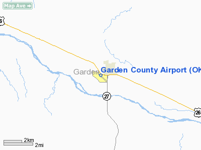
Location & QuickFacts
| FAA Information Effective: | 2008-09-25 |
| Airport Identifier: | OKS |
| Airport Status: | Operational |
| Longitude/Latitude: | 102-21-22.8656W/41-24-06.8799N
-102.356352/41.401911 (Estimated) |
| Elevation: | 3394 ft / 1034.49 m (Surveyed) |
| Land: | 181 acres |
| From nearest city: | 1 nautical miles SW of Oshkosh, NE |
| Location: | Garden County, NE |
| Magnetic Variation: | 09E (2005) |
Owner & Manager
| Ownership: | Publicly owned |
| Owner: | Garden County Arpt Authority
CLIFTON A. BUSKE, CHMN, 308-772-4482. |
| Address: | 15170 Hwy 26
Lisco, NE 69148-8827 |
| Phone number: | 308-772-4482 |
| Manager: | Clifton A. Buske |
| Address: | Rr1 Box 38
Oshkosh, NE 69154 |
| Phone number: | 308-772-4482 |
Airport Operations and Facilities
| Airport Use: | Open to public |
| Wind indicator: | Yes |
| Segmented Circle: | Yes |
| Control Tower: | No |
| Lighting Schedule: | DUSK-DAWN |
| Beacon Color: | Clear-Green (lighted land airport) |
| Landing fee charge: | No |
| Sectional chart: | Cheyenne |
| Region: | ACE - Central |
| Boundary ARTCC: | ZDV - Denver |
| Tie-in FSS: | OLU - Columbus |
| FSS on Airport: | No |
| FSS Toll Free: | 1-800-WX-BRIEF |
| NOTAMs Facility: | OLU (NOTAM-d service avaliable) |
| Federal Agreements: | NGY |
Airport Communications
| CTAF: | 122.800 |
| Unicom: | 122.800 |
Airport Services
| Fuel available: | 100LL
24 HR SELF SVC FUEL AVBL VIA CREDIT CARD SYSTEM. |
| Airframe Repair: | NONE |
| Power Plant Repair: | NONE |
| Bottled Oxygen: | NONE |
| Bulk Oxygen: | NONE |
Runway Information
Runway 12/30
| Dimension: | 4699 x 60 ft / 1432.3 x 18.3 m |
| Surface: | CONC, Good Condition |
| Weight Limit: | Single wheel: 15000 lbs. |
| Edge Lights: | Medium |
| |
Runway 12 |
Runway 30 |
| Longitude: | 102-21-45.1920W | 102-21-00.5200W |
| Latitude: | 41-24-22.8903N | 41-23-50.8694N |
| Elevation: | 3394.00 ft | 3380.00 ft |
| Alignment: | 127 | 127 |
| Traffic Pattern: | Left | Left |
| Markings: | Non-precision instrument, Good Condition | Non-precision instrument, Good Condition |
| Obstruction: | , 50:1 slope to clear | 21 ft poles, 1125.0 ft from runway, 200 ft left of centerline, 44:1 slope to clear |
|
Radio Navigation Aids
| ID |
Type |
Name |
Ch |
Freq |
Var |
Dist |
| OKS | NDB | Oshkosh | | 233.00 | 09E | 0.3 nm |
| CNP | NDB | Chappell | | 383.00 | 10E | 20.1 nm |
| GGF | NDB | Grant | | 359.00 | 09E | 42.7 nm |
| ALU | NDB | Alliance | | 380.00 | 11E | 43.4 nm |
| HEQ | NDB | Heginbotham | | 404.00 | 11E | 49.4 nm |
| SAE | VOR/DME | Searle | 39X | 110.20 | 11E | 31.2 nm |
| AIA | VOR/DME | Alliance | 055X | 111.80 | 11E | 44.1 nm |
| SNY | VORTAC | Sidney | 106X | 115.90 | 13E | 33.7 nm |
Images and information placed above are from
http://www.airport-data.com/airport/OKS/
We thank them for the data!
| General Info
|
| Country |
United States
|
| State |
NEBRASKA
|
| FAA ID |
OKS
|
| Latitude |
41-24-03.500N
|
| Longitude |
102-21-18.100W
|
| Elevation |
3388 feet
|
| Near City |
OSHKOSH
|
We don't guarantee the information is fresh and accurate. The data may
be wrong or outdated.
For more up-to-date information please refer to other sources.
|
|


