 |
|
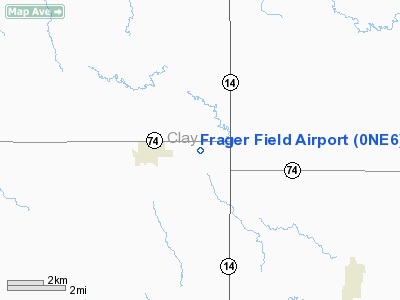
Location & QuickFacts
| FAA Information Effective: | 2008-09-25 |
| Airport Identifier: | 0NE6 |
| Airport Status: | Operational |
| Longitude/Latitude: | 098-04-14.1670W/40-26-00.0400N
-98.070602/40.433344 (Estimated) |
| Elevation: | 1765 ft / 537.97 m (Estimated) |
| Land: | 10 acres |
| From nearest city: | 2 nautical miles E of Fairfield, NE |
| Location: | Clay County, NE |
| Magnetic Variation: | 07E (1990) |
Owner & Manager
| Ownership: | Privately owned |
| Owner: | Frager Aerial Service Inc. |
| Address: | 3219 Northgate Circle
Fairbury, NE 68352-6153 |
| Phone number: | 402-729-6153 |
| Manager: | James R. Frager |
| Address: | 3219 Northgate Circle
Fairbury, NE 68352-6153 |
| Phone number: | 402-729-6153 |
Airport Operations and Facilities
| Airport Use: | Private |
| Wind indicator: | Yes |
| Segmented Circle: | No |
| Control Tower: | No |
| Sectional chart: | Omaha |
| Region: | ACE - Central |
| Boundary ARTCC: | ZMP - Minneapolis |
| Tie-in FSS: | OLU - Columbus |
| FSS on Airport: | No |
| FSS Toll Free: | 1-800-WX-BRIEF |
Airport Services
Runway Information
Runway 17/35
| Dimension: | 3700 x 80 ft / 1127.8 x 24.4 m |
| Surface: | ASPH, |
| |
Runway 17 |
Runway 35 |
| Traffic Pattern: | Left | Left |
| Displaced threshold: | 200.00 ft | 0.00 ft |
|
Radio Navigation Aids
| ID |
Type |
Name |
Ch |
Freq |
Var |
Dist |
| PSS | NDB | Prosser | | 338.00 | 07E | 24.0 nm |
| FMZ | NDB | Beklof | | 392.00 | 07E | 24.8 nm |
| HJH | NDB | Hebron | | 323.00 | 06E | 27.9 nm |
| JYR | NDB | York | | 257.00 | 06E | 34.7 nm |
| RPB | NDB | Republican | | 414.00 | 07E | 41.8 nm |
| FBY | NDB | Fairbury | | 293.00 | 06E | 44.2 nm |
| EAR | VOR | Kearney | | 111.20 | 10E | 46.1 nm |
| HSI | VOR/DME | Hastings | 025X | 108.80 | 07E | 19.4 nm |
| GRI | VORTAC | Grand Island | 057X | 112.00 | 07E | 34.9 nm |
| TKO | VORTAC | Mankato | 035X | 109.80 | 10E | 38.7 nm |
Remarks
- PRVDD A MIN 20:1 GLIDE SLOPE AND A 7:1 SLOPE FOR TRANSITIONAL SFC.
Images and information placed above are from
http://www.airport-data.com/airport/0NE6/
We thank them for the data!
| General Info
|
| Country |
United States
|
| State |
NEBRASKA
|
| FAA ID |
0NE6
|
| Latitude |
40-26-00.040N
|
| Longitude |
098-04-14.167W
|
| Elevation |
1765 feet
|
| Near City |
FAIRFIELD
|
We don't guarantee the information is fresh and accurate. The data may
be wrong or outdated.
For more up-to-date information please refer to other sources.
|
|


