 |
|
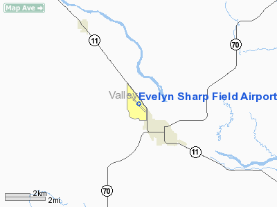
Evelyn Sharp Field Airport |
Location & QuickFacts
| FAA Information Effective: | 2008-09-25 |
| Airport Identifier: | ODX |
| Airport Status: | Operational |
| Longitude/Latitude: | 098-57-05.8888W/41-37-24.6689N
-98.951636/41.623519 (Estimated) |
| Elevation: | 2070 ft / 630.94 m (Surveyed) |
| Land: | 172 acres |
| From nearest city: | 2 nautical miles NW of Ord, NE |
| Location: | Valley County, NE |
| Magnetic Variation: | 07E (2000) |
Owner & Manager
| Ownership: | Publicly owned |
| Owner: | Valley County Airport Authority
DON VANTURA, CHMN ARPT AUTH. |
| Address: | Po Box 248
Ord, NE 68862 |
| Phone number: | 308-728-3201 |
| Manager: | Dave Williams |
| Address: | Route 3, Box 147c-1, 1411 M St
Ord, NE 68862 |
| Phone number: | 308-728-3913 |
Airport Operations and Facilities
| Airport Use: | Open to public |
| Wind indicator: | Yes |
| Segmented Circle: | No |
| Control Tower: | No |
| Lighting Schedule: | DUSK-DAWN |
| Beacon Color: | Clear-Green (lighted land airport) |
| Landing fee charge: | No |
| Sectional chart: | Omaha |
| Region: | ACE - Central |
| Boundary ARTCC: | ZMP - Minneapolis |
| Tie-in FSS: | OLU - Columbus |
| FSS on Airport: | No |
| FSS Toll Free: | 1-800-WX-BRIEF |
| NOTAMs Facility: | ODX (NOTAM-d service avaliable) |
| Federal Agreements: | NGY |
Airport Communications
| CTAF: | 122.800 |
| Unicom: | 122.800 |
Airport Services
| Fuel available: | 100LL |
| Bottled Oxygen: | NONE |
| Bulk Oxygen: | NONE |
Runway Information
Runway 13/31
| Dimension: | 4500 x 60 ft / 1371.6 x 18.3 m |
| Surface: | CONC, Good Condition |
| Weight Limit: | Single wheel: 8000 lbs. |
| Edge Lights: | Medium |
| |
Runway 13 |
Runway 31 |
| Longitude: | 098-57-29.0970W | 098-56-47.9240W |
| Latitude: | 41-37-43.2620N | 41-37-11.2970N |
| Elevation: | 2070.00 ft | 2059.00 ft |
| Alignment: | 127 | 127 |
| Traffic Pattern: | Left | Left |
| Markings: | Non-precision instrument, Good Condition | Non-precision instrument, Good Condition |
| Obstruction: | 107 ft trees, 2820.0 ft from runway, 80 ft right of centerline, 24:1 slope to clear | 16 ft pline, 650.0 ft from runway, 28:1 slope to clear |
|
Runway 17/35
| Dimension: | 2012 x 218 ft / 613.3 x 66.4 m |
| Surface: | TURF, Fair Condition |
| |
Runway 17 |
Runway 35 |
| Longitude: | 098-57-00.1918W | 098-56-59.8614W |
| Latitude: | 41-37-28.7668N | 41-37-08.8970N |
| Elevation: | 2060.00 ft | 2060.00 ft |
| Alignment: | 127 | 127 |
| Traffic Pattern: | Left | Left |
| Obstruction: | 19 ft road, 550.0 ft from runway, 28:1 slope to clear | 5 ft fence, 110.0 ft from runway, 22:1 slope to clear |
|
Radio Navigation Aids
| ID |
Type |
Name |
Ch |
Freq |
Var |
Dist |
| ODX | NDB | Ord | | 356.00 | 07E | 0.2 nm |
| BUB | NDB | Burwell | | 377.00 | 07E | 12.6 nm |
| BBW | NDB | Broken Bow | | 265.00 | 08E | 32.8 nm |
| BVN | NDB | Alaby | | 332.00 | 06E | 40.9 nm |
| CUZ | VOR/DME | Custer County | 19X | 108.20 | 08E | 34.2 nm |
| OBH | VORTAC | Wolbach | 095X | 114.80 | 07E | 30.8 nm |
| GRI | VORTAC | Grand Island | 057X | 112.00 | 07E | 48.0 nm |
Images and information placed above are from
http://www.airport-data.com/airport/ODX/
We thank them for the data!
| General Info
|
| Country |
United States
|
| State |
NEBRASKA
|
| FAA ID |
ODX
|
| Latitude |
41-37-27.300N
|
| Longitude |
098-57-08.500W
|
| Elevation |
2070 feet
|
| Near City |
ORD
|
We don't guarantee the information is fresh and accurate. The data may
be wrong or outdated.
For more up-to-date information please refer to other sources.
|
|


