|
|
| Eppley Airfield |
 |
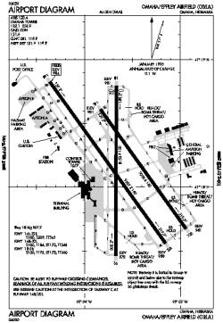
| FAA airport diagram |
| IATA: OMA – ICAO: KOMA – FAA LID: OMA
Location of the Eppley Airfield
|
| Summary |
| Airport type |
Public |
| Operator |
Omaha Airport Authority |
| Serves |
Greater Omaha, Nebraska |
| Elevation AMSL |
983 ft / 300 m |
| Coordinates |
41°18.12′N 95°53.62′W / 41.302°N 95.89367°W / 41.302; -95.89367 |
| Website |
flyoma.com |
| Runways |
| Direction |
Length |
Surface |
| ft |
m |
| 14R/32L |
9,502 |
2,896 |
Asphalt/Concrete |
| 14L/32R |
8,500 |
2,591 |
Concrete |
| 18/36 |
8,153 |
2,485 |
Asphalt/Concrete |
| Statistics (2009) |
| Passengers |
4,217,718 |
| Aircraft operations |
111,155 |
| Cargo in pounds |
102,149,802 |
| Mail in pounds |
54,305,909 |
| Sources: FAA and airport web site |
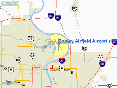
Eppley Airfield (IATA: OMA, ICAO: KOMA, FAA LID: OMA) is a medium hub primary airport located three miles (5 km) northeast of the central business district of Omaha, a city in Douglas County, Nebraska, United States. It is the largest airport in the state of Nebraska. In addition to the Omaha-Council Bluffs metropolitan area, Eppley Airfield serves communities throughout eastern Nebraska, western Iowa, northern Kansas, Missouri, and South Dakota.
The airport is named for Eugene C. Eppley, the Omaha Eppley Hotel magnate, from whose estate $1 million was used to convert the Omaha Municipal Airport into a jet port in 1959/1960.
The airport occupies 2,650 acres (10.7 km) and handles about 397 commercial flights a week. The airport has two concourses consisting of 20 gates. Midwest Airlines has established a focus city at Eppley Airfield. As of March 2010, all regularly-scheduled flights from Eppley Airfield terminate within the United States. The airport handled more than 4.2 million passengers in 2009. Southwest Airlines is the largest carrier, handling approximately 27 percent of passengers; United Airlines is the second-largest carrier, handling approximately 19 percent of passengers. The airport is served by MAT bus #16. Location
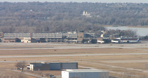 | |
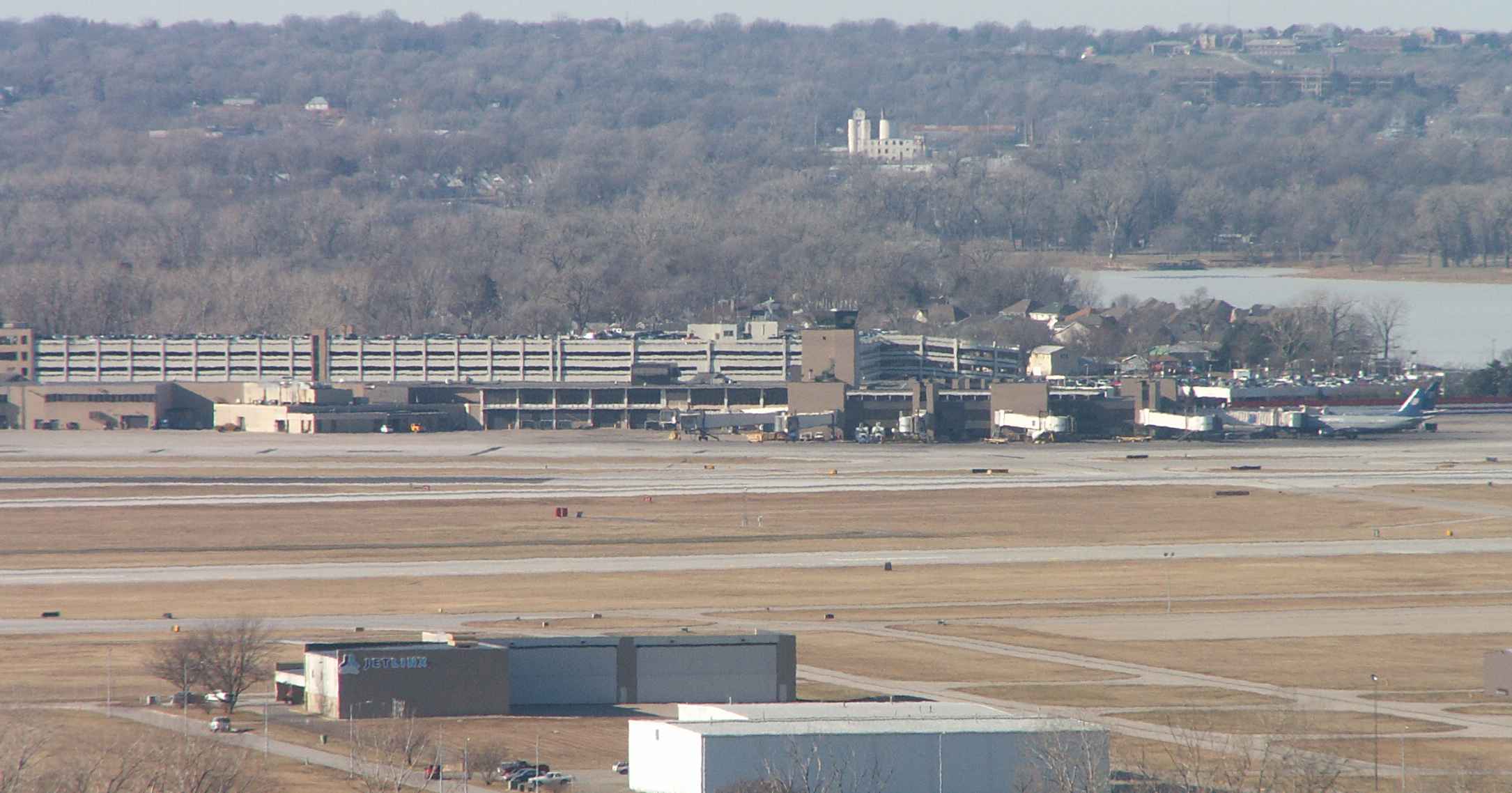
Eppley Airfield terminal in Omaha. The houses immediately behind are in Carter Lake, Iowa (with Carter Lake visible to the right). The bluffs are in Omaha. |
The airport is located northeast of downtown Omaha in east Omaha. Although the airport is in Nebraska and on the west side of the Missouri River, through a geographic oddity it is surrounded on the east, west and south by the state of Iowa: the Missouri River formerly formed an oxbow immediately west of the land that became Eppley Airfield. The river cut off the oxbow during an 1877 flood, leaving behind Carter Lake on a portion of its former course; the Supreme Court ruled in 1893 that though the land cut off by the river's changed route now lay west of the Missouri, it remained part of Iowa. This land eventually became the city of Carter Lake, Iowa.
People driving from downtown Omaha must go through a small section of Iowa to reach the airport. The main road connecting the airport to downtown is Abbott Drive; just south of the airport, Abbott Drive is signed as Iowa Highway 165 for 0.5 miles (0.80 km) in Carter Lake. In Iowa, Abbott Drive is maintained by the Iowa Department of Transportation and has Iowa welcome signs on either side; in Nebraska, Abbott Drive in Nebraska is an Omaha city street and has no Nebraska welcome signs (which would be provided by the state). Travelers coming from the north from north Omaha and the north shore of Carter Lake in East Omaha can access the airport by staying in Nebraska the entire time.
History
On August 6 1966, Braniff Airways Flight 250 left Kansas City Downtown Airport headed for Eppley and crashed near Falls City, Nebraska, killing all 42 on board. The flight was waiting for weather to clear in Omaha before descending when violent turbulence compromised the structural integrity of the plane.
The 2002 feature film About Schmidt included scenes filmed in and outside the terminal.
The 2009 feature film Up in the Air made use of the south end of the terminal building during filming.
Airlines and destinations
Eppley Airfield has two passenger concourses: Concourse A (gates A1-A10) and Concourse B (gates B11-B20).
| Airlines |
Destinations |
Concourse |
| AirTran Airways operated by SkyWest Airlines |
Milwaukee |
A |
| American Airlines |
Dallas/Fort Worth |
A |
| American Eagle |
Chicago-O'Hare |
A |
| Continental Airlines |
Houston-Intercontinental |
B |
| Continental Express operated by ExpressJet Airlines |
Houston-Intercontinental, Newark |
B |
| Delta Air Lines |
Atlanta, Minneapolis/St. Paul |
A |
| Delta Connection operated by Atlantic Southeast Airlines |
Atlanta, Detroit, Memphis |
A |
| Delta Connection operated by Comair |
Cincinnati/Northern Kentucky, Detroit, Memphis, New York-LaGuardia |
A |
| Delta Connection operated by Compass Airlines |
Minneapolis/St. Paul |
A |
| Delta Connection operated by Mesaba Airlines |
Minneapolis/St. Paul |
A |
| Delta Connection operated by Pinnacle Airlines |
Minneapolis/St. Paul |
A |
| Delta Connection operated by SkyWest Airlines |
Minneapolis/St. Paul, Salt Lake City |
A |
| Frontier Airlines |
Denver |
A |
| Frontier Airlines operated by Chautauqua Airlines |
Milwaukee |
A |
| Frontier Airlines operated by Republic Airlines |
Denver, Los Angeles [begins February 14], Milwaukee, Orlando [seasonal, begins January 15], San Diego [begins January 16], St. Petersburg/Clearwater [seasonal, begins January 16], Washington-Reagan |
A |
| Southwest Airlines |
Chicago-Midway, Denver, Las Vegas, Orlando [seasonal], Phoenix, St. Louis |
B |
| United Airlines |
Chicago-O'Hare, Denver |
B |
| United Express operated by GoJet Airlines |
Chicago-O'Hare, Denver |
B |
| United Express operated by SkyWest Airlines |
Chicago-O'Hare, Denver |
B |
| United Express operated by Trans States Airlines |
Chicago-O'Hare, Denver |
B |
| US Airways |
Phoenix |
B |
| US Airways Express operated by Mesa Airlines |
Phoenix |
B |
The above content comes from Wikipedia and is published under free licenses – click here to read more.
Location & QuickFacts
| FAA Information Effective: | 2008-09-25 |
| Airport Identifier: | OMA |
| Airport Status: | Operational |
| Longitude/Latitude: | 095-53-38.6460W/41-18-11.3990N
-95.894068/41.303166 (Estimated) |
| Elevation: | 984 ft / 299.92 m (Surveyed) |
| Land: | 2650 acres |
| From nearest city: | 3 nautical miles NE of Omaha, NE |
| Location: | Douglas County, NE |
| Magnetic Variation: | 05E (2000) |
Owner & Manager
| Ownership: | Publicly owned |
| Owner: | Omaha Airport Authority |
| Address: | 4501 Abbott Drive, Suite 2300
Omaha, NE 68110 |
| Phone number: | 402-661-8000 |
| Manager: | Donald L. Smithey
EXECUTIVE DIR OF ARPT AUTH. |
| Address: | 4501 Abbott Drive, Suite 2300
Omaha, NE 68110 |
| Phone number: | 402-661-8000 |
Airport Operations and Facilities
| Airport Use: | Open to public |
| Wind indicator: | Yes |
| Segmented Circle: | No |
| Control Tower: | Yes |
| Lighting Schedule: | 24 HRS |
| Beacon Color: | Clear-Green (lighted land airport) |
| Landing fee charge: | No |
| Sectional chart: | Omaha |
| Region: | ACE - Central |
| Boundary ARTCC: | ZMP - Minneapolis |
| Tie-in FSS: | OLU - Columbus |
| FSS on Airport: | No |
| FSS Toll Free: | 1-800-WX-BRIEF |
| NOTAMs Facility: | OMA (NOTAM-d service avaliable) |
| Certification type/date: | I C S 05/1973 |
| Federal Agreements: | NGY |
Airport Communications
Airport Services
| Fuel available: | 100LLA |
| Airframe Repair: | MAJOR |
| Power Plant Repair: | MAJOR |
| Bottled Oxygen: | LOW |
| Bulk Oxygen: | NONE |
Runway Information
Runway 14L/32R
| Dimension: | 8500 x 150 ft / 2590.8 x 45.7 m |
| Surface: | CONC,
1,000 FT NORTH OF RY 14R IS CONC. |
| Surface Treatment: | Saw-cut or plastic Grooved |
| Weight Limit: | Single wheel: 100000 lbs.
Dual wheel: 209000 lbs.
Dual tandem wheel: 345000 lbs. |
| Edge Lights: | High |
| |
Runway 14L |
Runway 32R |
| Longitude: | 095-54-01.5000W | 095-52-56.6600W |
| Latitude: | 41-18-48.7100N | 41-17-40.4300N |
| Elevation: | 983.00 ft | 981.00 ft |
| Alignment: | 127 | 127 |
| ILS Type: | ILS/DME
| ILS/DME
|
| Traffic Pattern: | Left | Right |
| Markings: | Precision instrument, Good Condition | Precision instrument, Good Condition |
| Crossing Height: | 0.00 ft | 50.00 ft |
| VASI: | | 4-light PAPI on right side |
| Visual Glide Angle: | 0.00° | 3.00° |
| RVR Equipment: | touchdown, midfield, rollout | touchdown, midfield, rollout |
| Approach lights: | MALSR | ALSF2 |
| Centerline Lights: | Yes | Yes |
| Touchdown Lights: | No | Yes |
| Decleard distances: | Take off run available 8500.00 ft
Take off distance available 8500.00 ft
Actual stop distance available 8500.00 ft
Landing distance available 8500.00 ft
| Take off run available 8500.00 ft
Take off distance available 8500.00 ft
Actual stop distance available 8500.00 ft
Landing distance available 8500.00 ft
|
|
Runway 14R/32L
| Dimension: | 9502 x 150 ft / 2896.2 x 45.7 m |
| Surface: | ASPH-CONC, Good Condition
1,000 FT NORTH OF RY 14R IS CONC. |
| Surface Treatment: | Saw-cut or plastic Grooved |
| Weight Limit: | Single wheel: 100000 lbs.
Dual wheel: 184000 lbs.
Dual tandem wheel: 346000 lbs. |
| Edge Lights: | High |
| |
Runway 14R |
Runway 32L |
| Longitude: | 095-54-21.9065W | 095-53-09.4180W |
| Latitude: | 41-18-49.8300N | 41-17-33.5043N |
| Elevation: | 984.00 ft | 980.00 ft |
| Alignment: | 127 | 127 |
| ILS Type: | ILS
| ILS
|
| Traffic Pattern: | Left | Left |
| Markings: | Precision instrument, Good Condition | Precision instrument, Good Condition |
| Crossing Height: | 55.00 ft | 52.00 ft |
| VASI: | 4-light PAPI on left side | 4-light PAPI on right side |
| Visual Glide Angle: | 3.00° | 3.00° |
| RVR Equipment: | touchdown, midfield, rollout | touchdown, midfield, rollout |
| Approach lights: | ALSF2 | MALSR |
| Centerline Lights: | Yes | Yes |
| Touchdown Lights: | Yes | No |
| Decleard distances: | Take off run available 9502.00 ft
Take off distance available 9502.00 ft
Actual stop distance available 9502.00 ft
Landing distance available 9502.00 ft
| Take off run available 9502.00 ft
Take off distance available 9502.00 ft
Actual stop distance available 9502.00 ft
Landing distance available 9502.00 ft
|
|
Runway 18/36
| Dimension: | 8153 x 150 ft / 2485.0 x 45.7 m |
| Surface: | ASPH-CONC,
1,000 FT NORTH OF RY 14R IS CONC. |
| Surface Treatment: | Saw-cut or plastic Grooved |
| Weight Limit: | Single wheel: 150000 lbs.
Dual wheel: 175000 lbs.
Dual tandem wheel: 260000 lbs. |
| Edge Lights: | High |
| |
Runway 18 |
Runway 36 |
| Longitude: | 095-53-40.2329W | 095-53-40.6460W |
| Latitude: | 41-18-48.0579N | 41-17-27.5040N |
| Elevation: | 981.00 ft | 978.00 ft |
| Alignment: | 127 | 0 |
| ILS Type: | ILS/DME
| ILS/DME
|
| Traffic Pattern: | Left | Left |
| Markings: | Precision instrument, Good Condition | Precision instrument, Good Condition |
| Crossing Height: | 52.00 ft | 57.00 ft |
| Displaced threshold: | 140.00 ft | 0.00 ft |
| VASI: | 4-light PAPI on left side | 4-light PAPI on left side |
| Visual Glide Angle: | 3.00° | 3.00° |
| RVR Equipment: | touchdown, midfield | |
| Approach lights: | MALSR | MALSR |
| Decleard distances: | Take off run available 8153.00 ft
Take off distance available 8153.00 ft
Actual stop distance available 8153.00 ft
Landing distance available 8013.00 ft
| Take off run available 8153.00 ft
Take off distance available 8153.00 ft
Actual stop distance available 8153.00 ft
Landing distance available 8153.00 ft
|
|
Radio Navigation Aids
| ID |
Type |
Name |
Ch |
Freq |
Var |
Dist |
| OM | NDB | Gerfi | | 320.00 | 05E | 4.8 nm |
| MLE | NDB | Millard | | 371.00 | 06E | 11.9 nm |
| PMV | NDB | Plattsmouth | | 329.00 | 06E | 21.6 nm |
| FET | NDB | Fremont | | 311.00 | 06E | 29.5 nm |
| HNR | NDB | Harlan | | 272.00 | 05E | 29.9 nm |
| AHQ | NDB | Wahoo | | 400.00 | 07E | 32.0 nm |
| RDK | NDB | Red Oak | | 230.00 | 04E | 33.7 nm |
| AIO | NDB | Atlantic | | 365.00 | 04E | 38.7 nm |
| SDA | NDB | Shenandoah | | 411.00 | 05E | 39.8 nm |
| AFK | NDB | Nebraska City | | 347.00 | 05E | 42.0 nm |
| DNS | NDB | Denison | | 350.00 | 04E | 47.0 nm |
| OFF | TACAN | Offutt | 054X | | 05E | 11.2 nm |
| TQE | VOR | Tekamah | | 108.40 | 07E | 30.3 nm |
| SCB | VOR/DME | Scribner | 47X | 111.00 | 06E | 37.7 nm |
| OVR | VORTAC | Omaha | 110X | 116.30 | 08E | 10.8 nm |
| LNK | VORTAC | Lincoln | 108X | 116.10 | 09E | 44.7 nm |
| OMA | VOT | Omaha | | 109.00 | | 0.6 nm |
Remarks
- BIRDS ON AND INVOF ARPT.
- ACFT RATED 12,500 LBS OR GREATER, RESTRICTED FM 180 DEG TURNS ON RY 14R/32L, SOUTH OF TWY 'H' & RY 18/36 BTN TWY "A" & RY 14R HOLD SHORT SIGN ON RY 18.
- NOISE MITIGATION PROCEDURES PROHIBIT VFR PATTERNS FOR MILITARY TURBOJET ACFT BETWEEN 0500-1200Z.
- GROUP IV & LARGER ACFT WITH A WINGSPAN GREATER THAN 158 FT ARE PROHIBITED FM USING TWY 'E' EAST OF RY 18/36 DUE TO THE LOCATION OF THE RY 36 ILS GLIDESLOPE ANT.
- USE CAUTION FOR MOWERS ADJACENT TO MOVEMENT AREA FM MAR THRU OCT.
Images and information placed above are from
http://www.airport-data.com/airport/OMA/
We thank them for the data!
| General Info
|
| Country |
United States
|
| State |
NEBRASKA
|
| FAA ID |
OMA
|
| Latitude |
41-18-07.899N
|
| Longitude |
095-53-37.188W
|
| Elevation |
984 feet
|
| Near City |
OMAHA
|
We don't guarantee the information is fresh and accurate. The data may
be wrong or outdated.
For more up-to-date information please refer to other sources.
|
|