 |
|
Coordinates: 41°26′53″N 097°20′34″W / 41.44806°N 97.34278°W / 41.44806; -97.34278
| Columbus Municipal Airport |
| IATA: OLU – ICAO: KOLU – FAA LID: OLU |
| Summary |
| Airport type |
Public |
| Owner |
Columbus Airport Authority |
| Serves |
Columbus, Nebraska |
| Elevation AMSL |
1,447 ft / 441 m |
| Runways |
| Direction |
Length |
Surface |
| ft |
m |
| 14/32 |
6,800 |
2,073 |
Concrete |
| 2/20 |
4,135 |
1,260 |
Turf |
| Statistics (2007) |
| Aircraft operations |
15,000 |
| Source: Federal Aviation Administration |
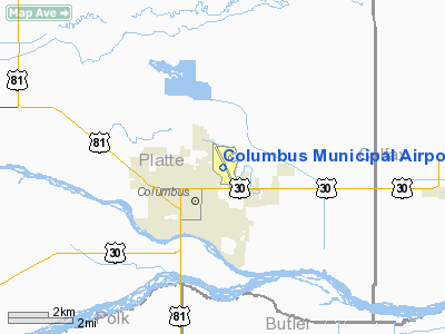
Columbus Municipal Airport (IATA: OLU, ICAO: KOLU, FAA LID: OLU) is a public airport located one mile (2 km) northeast of the central business district of Columbus, in Platte County, Nebraska, United States. It is owned by the Columbus Airport Authority.
Facilities and aircraft
The airport covers an area of 602 acres (244 ha), and contains two runways: 14/32 with a concrete pavement measuring 6,800 x 100 ft (2,073 x 30 m); and 2/20 with a turf surface measuring 4,135 x 150 ft (1,260 x 46 m). For the 12-month period ending August 24, 2007, the airport had 15,000 aircraft operations, an average of 41 per day: 97% general aviation, 3% air taxi and <1% military.
The above content comes from Wikipedia and is published under free licenses – click here to read more.
Location & QuickFacts
| FAA Information Effective: | 2008-09-25 |
| Airport Identifier: | OLU |
| Airport Status: | Operational |
| Longitude/Latitude: | 097-20-33.5000W/41-26-52.8000N
-97.342639/41.448000 (Estimated) |
| Elevation: | 1447 ft / 441.05 m (Surveyed) |
| Land: | 602 acres |
| From nearest city: | 1 nautical miles NE of Columbus, NE |
| Location: | Platte County, NE |
| Magnetic Variation: | 08E (1980) |
Owner & Manager
| Ownership: | Publicly owned |
| Owner: | Columbus Airport Authority |
| Address: | 1308 Bill Babka Drive
Columbus, NE 68601-2076 |
| Phone number: | 402-910-8113 |
| Manager: | Jerry L. Schultz |
| Address: | 1308 Bill Babka Drive, 2765 14th Ave
Columbus, NE 68601-2076 |
| Phone number: | 402-564-7377 |
Airport Operations and Facilities
| Airport Use: | Open to public |
| Wind indicator: | Yes |
| Segmented Circle: | Yes |
| Control Tower: | No |
| Lighting Schedule: | DUSK-DAWN
ACTVT MIRL RY 14/32; PAPI RY 14; VASI RY 32; REIL RY 32 & MALSR RY 14 - CTAF. |
| Beacon Color: | Clear-Green (lighted land airport) |
| Landing fee charge: | No |
| Sectional chart: | Omaha |
| Region: | ACE - Central |
| Boundary ARTCC: | ZMP - Minneapolis |
| Tie-in FSS: | OLU - Columbus |
| FSS on Airport: | No |
| FSS Toll Free: | 1-800-WX-BRIEF |
| NOTAMs Facility: | OLU (NOTAM-d service avaliable) |
| Federal Agreements: | NGY |
Airport Communications
| CTAF: | 123.050 |
| Unicom: | 123.050 |
Airport Services
| Fuel available: | 100LLA
FOR FUEL AFT HRS CONTACT 402-910-5246, 402-910-5247 OR 402-563-4143. |
| Airframe Repair: | MAJOR |
| Power Plant Repair: | MAJOR |
| Bottled Oxygen: | NONE |
| Bulk Oxygen: | NONE |
Runway Information
Runway 02/20
| Dimension: | 4135 x 150 ft / 1260.3 x 45.7 m |
| Surface: | TURF, Fair Condition |
| |
Runway 02 |
Runway 20 |
| Longitude: | 097-20-24.9190W | 097-19-57.8990W |
| Latitude: | 41-26-34.1270N | 41-27-09.5610N |
| Elevation: | 1440.00 ft | 1439.00 ft |
| Alignment: | 30 | 127 |
| Traffic Pattern: | Left | Left |
| Obstruction: | 14 ft bldg, 420.0 ft from runway, 100 ft left of centerline, 30:1 slope to clear | 45 ft pline, 1480.0 ft from runway, 32:1 slope to clear |
|
Runway 14/32
| Dimension: | 6800 x 100 ft / 2072.6 x 30.5 m |
| Surface: | CONC, Good Condition |
| Weight Limit: | Single wheel: 43000 lbs.
Dual wheel: 58000 lbs. |
| Edge Lights: | Medium |
| |
Runway 14 |
Runway 32 |
| Longitude: | 097-20-59.6100W | 097-20-14.7200W |
| Latitude: | 41-27-26.6530N | 41-26-28.5740N |
| Elevation: | 1447.00 ft | 1440.00 ft |
| Alignment: | 127 | 127 |
| ILS Type: | LOCALIZER
| |
| Traffic Pattern: | Left | Left |
| Markings: | Precision instrument, Good Condition | Precision instrument, Good Condition |
| Crossing Height: | 40.00 ft | 44.00 ft |
| Displaced threshold: | 0.00 ft | 950.00 ft |
| VASI: | 4-light PAPI on left side | 4-box on left side |
| Visual Glide Angle: | 3.00° | 3.00° |
| Approach lights: | MALSR | |
| Runway End Identifier: | No | Yes |
| Obstruction: | , 50:1 slope to clear | 31 ft bldg, 925.0 ft from runway, 600 ft right of centerline, 23:1 slope to clear |
| Decleard distances: | Take off run available 6800.00 ft
Take off distance available 6800.00 ft
Actual stop distance available 6260.00 ft
Landing distance available 6260.00 ft
| Take off run available 6800.00 ft
Take off distance available 6800.00 ft
Actual stop distance available 6800.00 ft
Landing distance available 5850.00 ft
|
|
Radio Navigation Aids
| ID |
Type |
Name |
Ch |
Freq |
Var |
Dist |
| PLT | NDB | Platte Center | | 407.00 | 08E | 3.4 nm |
| OF | NDB | Carsy | | 510.00 | 08E | 27.1 nm |
| JYR | NDB | York | | 257.00 | 06E | 35.3 nm |
| AHQ | NDB | Wahoo | | 400.00 | 07E | 35.9 nm |
| BVN | NDB | Alaby | | 332.00 | 06E | 36.1 nm |
| SWT | NDB | Seward | | 269.00 | 06E | 36.8 nm |
| FET | NDB | Fremont | | 311.00 | 06E | 37.1 nm |
| LN | NDB | Potts | | 385.00 | 06E | 49.7 nm |
| OLU | VOR/DME | Columbus | 055X | 111.80 | 08E | 0.1 nm |
| OFK | VOR/DME | Norfolk | 033X | 109.60 | 08E | 32.7 nm |
| SCB | VOR/DME | Scribner | 47X | 111.00 | 06E | 33.5 nm |
| LNK | VORTAC | Lincoln | 108X | 116.10 | 09E | 41.6 nm |
| OBH | VORTAC | Wolbach | 095X | 114.80 | 07E | 45.8 nm |
Remarks
- WATERFOWL INVOF ARPT.
- DEER INVOF ARPT.
- RY 32 IS DESIGNATED AS THE CALM WIND RY.
Images and information placed above are from
http://www.airport-data.com/airport/OLU/
We thank them for the data!
| General Info
|
| Country |
United States
|
| State |
NEBRASKA
|
| FAA ID |
OLU
|
| Latitude |
41-26-52.800N
|
| Longitude |
097-20-33.500W
|
| Elevation |
1444 feet
|
| Near City |
COLUMBUS
|
We don't guarantee the information is fresh and accurate. The data may
be wrong or outdated.
For more up-to-date information please refer to other sources.
|
|


