 |
|
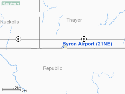
Location & QuickFacts
| FAA Information Effective: | 2008-09-25 |
| Airport Identifier: | 21NE |
| Airport Status: | Operational |
| Longitude/Latitude: | 097-46-23.1520W/40-00-15.0380N
-97.773098/40.004177 (Estimated) |
| Elevation: | 1670 ft / 509.02 m (Estimated) |
| Land: | 0 acres |
| From nearest city: | 0 nautical miles W of Byron, NE |
| Location: | Thayer County, NE |
| Magnetic Variation: | 07E (1985) |
Owner & Manager
| Ownership: | Privately owned |
| Owner: | Verland Tietjen |
| Address: | Box 126
Byron, NE 68325 |
| Phone number: | 402-236-8626 |
| Address: |
|
| Phone number: | 402-236-8835 |
Airport Operations and Facilities
| Airport Use: | Private |
| Wind indicator: | Yes |
| Segmented Circle: | No |
| Control Tower: | No |
| Landing fee charge: | No |
| Sectional chart: | Omaha |
| Region: | ACE - Central |
| Boundary ARTCC: | ZMP - Minneapolis |
| Tie-in FSS: | OLU - Columbus |
| FSS on Airport: | No |
| FSS Toll Free: | 1-800-WX-BRIEF |
Runway Information
Runway N/S
| Dimension: | 2200 x 100 ft / 670.6 x 30.5 m |
| Surface: | TURF, Good Condition |
| |
Runway N |
Runway S |
| Traffic Pattern: | Left | Left |
|
Radio Navigation Aids
| ID |
Type |
Name |
Ch |
Freq |
Var |
Dist |
| HJH | NDB | Hebron | | 323.00 | 06E | 12.2 nm |
| RPB | NDB | Republican | | 414.00 | 07E | 12.6 nm |
| CNK | NDB | Concordia | | 335.00 | 06E | 27.7 nm |
| FBY | NDB | Fairbury | | 293.00 | 06E | 29.8 nm |
| FMZ | NDB | Beklof | | 392.00 | 07E | 36.4 nm |
| DBX | NDB | Morrison | | 212.00 | 06E | 36.7 nm |
| CYW | NDB | Clay Center | | 362.00 | 07E | 47.0 nm |
| BJU | NDB | Big Blue | | 248.00 | 06E | 49.1 nm |
| HWB | NDB | Shaw | | 263.00 | 06E | 49.3 nm |
| HSI | VOR/DME | Hastings | 025X | 108.80 | 07E | 47.0 nm |
| TKO | VORTAC | Mankato | 035X | 109.80 | 10E | 25.4 nm |
Remarks
- PRVDD APCH TO EACH RWY IS MAINTD FOR MIN 20-1 GLIDE SLOPE & TRSNL SFC BE MAINTD FOR 7-1 SLOPE.
Images and information placed above are from
http://www.airport-data.com/airport/21NE/
We thank them for the data!
| General Info
|
| Country |
United States
|
| State |
NEBRASKA
|
| FAA ID |
21NE
|
| Latitude |
40-00-15.038N
|
| Longitude |
097-46-23.152W
|
| Elevation |
1670 feet
|
| Near City |
BYRON
|
We don't guarantee the information is fresh and accurate. The data may
be wrong or outdated.
For more up-to-date information please refer to other sources.
|
|


