 |
|
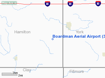
Location & QuickFacts
| FAA Information Effective: | 2008-09-25 |
| Airport Identifier: | 38NE |
| Airport Status: | Operational |
| Longitude/Latitude: | 097-51-05.1790W/40-45-13.0380N
-97.851439/40.753622 (Estimated) |
| Elevation: | 1720 ft / 524.26 m (Estimated) |
| Land: | 0 acres |
| From nearest city: | 2 nautical miles SW of Henderson, NE |
| Location: | Hamilton County, NE |
| Magnetic Variation: | 07E (1985) |
Owner & Manager
| Ownership: | Privately owned |
| Owner: | Rick Boardman |
| Address: | 2306 E 5th Road
Henderson, NE 68371 |
| Phone number: | 402-723-4952 |
| Manager: | Rick Boardman |
| Address: | 2306 E 5th Road
Henderson, NE 68371 |
| Phone number: | 402-723-4952 |
Airport Operations and Facilities
| Airport Use: | Private |
| Wind indicator: | Yes |
| Segmented Circle: | No |
| Control Tower: | No |
| Landing fee charge: | No |
| Sectional chart: | Omaha |
| Region: | ACE - Central |
| Boundary ARTCC: | ZMP - Minneapolis |
| Tie-in FSS: | OLU - Columbus |
| FSS on Airport: | No |
| FSS Toll Free: | 1-800-WX-BRIEF |
Runway Information
Runway 17/35
| Dimension: | 2940 x 24 ft / 896.1 x 7.3 m |
| Surface: | ASPH, |
| |
Runway 17 |
Runway 35 |
| Traffic Pattern: | Left | Left |
|
Radio Navigation Aids
| ID |
Type |
Name |
Ch |
Freq |
Var |
Dist |
| JYR | NDB | York | | 257.00 | 06E | 13.7 nm |
| FMZ | NDB | Beklof | | 392.00 | 07E | 16.2 nm |
| PSS | NDB | Prosser | | 338.00 | 07E | 28.8 nm |
| SWT | NDB | Seward | | 269.00 | 06E | 34.3 nm |
| HJH | NDB | Hebron | | 323.00 | 06E | 38.2 nm |
| FBY | NDB | Fairbury | | 293.00 | 06E | 46.7 nm |
| PLT | NDB | Platte Center | | 407.00 | 08E | 49.5 nm |
| LN | NDB | Potts | | 385.00 | 06E | 49.6 nm |
| HSI | VOR/DME | Hastings | 025X | 108.80 | 07E | 27.8 nm |
| OLU | VOR/DME | Columbus | 055X | 111.80 | 08E | 47.8 nm |
| GRI | VORTAC | Grand Island | 057X | 112.00 | 07E | 25.2 nm |
| OBH | VORTAC | Wolbach | 095X | 114.80 | 07E | 43.8 nm |
Remarks
- PROVIDED THAT THE APPROACH TO EACH RWY IS MAINTAINED FOR A MINIMUM 20:1 GLIDE SLOPE AND THAT THE TRANSITIONAL SURFACE BE MAINTAINED FOR A 7:1 SLOPE.
Images and information placed above are from
http://www.airport-data.com/airport/38NE/
We thank them for the data!
| General Info
|
| Country |
United States
|
| State |
NEBRASKA
|
| FAA ID |
38NE
|
| Latitude |
40-45-13.038N
|
| Longitude |
097-51-05.179W
|
| Elevation |
1720 feet
|
| Near City |
HENDERSON
|
We don't guarantee the information is fresh and accurate. The data may
be wrong or outdated.
For more up-to-date information please refer to other sources.
|
|


