 |
|
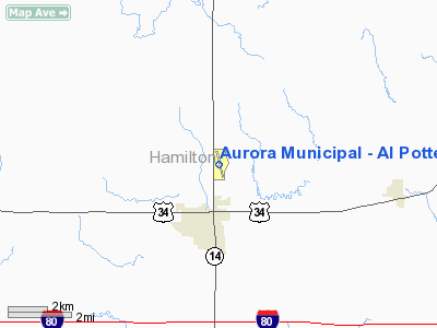
Aurora Muni - Al Potter Field Airport |
Aurora Municipal Airport
Al Potter Field |
| IATA: none – ICAO: KAUH – FAA LID: AUH |
| Summary |
| Airport type |
Public |
| Operator |
Aurora Airport Authority |
| Serves |
Aurora, Nebraska |
| Elevation AMSL |
1,804 ft / 550 m |
| Coordinates |
40°53′39″N 097°59′40″W / 40.89417°N 97.99444°W / 40.89417; -97.99444 |
| Website |
www.cityofaurora.org |
| Runways |
| Direction |
Length |
Surface |
| ft |
m |
| 16/34 |
4,301 |
1,311 |
Asphalt |
| Statistics (2006) |
| Aircraft operations |
15,925 |
| Based aircraft |
31 |
| Source: Federal Aviation Administration |
Aurora Municipal Airport (ICAO: KAUH, FAA LID: AUH), also known as Al Potter Field, is a public airport located two miles (3 km) north of the central business district of Aurora, a city in Hamilton County, Nebraska, United States. It is owned by Aurora Airport Authority.
Although most U.S. airports use the same three-letter location identifier for the FAA and IATA, Aurora Municipal Airport is assigned AUH by the FAA but has no designation from the IATA (which assigned AUH to Abu Dhabi International Airport in the United Arab Emirates).
Facilities
Aurora Municipal Airport - Al Potter Field covers an area of 171 acres (69 ha) which contains one asphalt paved runway (16/34) measuring 4,301 x 75 ft (1,311 x 23 m). For the 12-month period ending April 4, 2006, the airport had 15,925 aircraft operations, an average of 43 per day: 100% general aviation and <1% military. There are 31 aircraft based at this airport: 87% single engine, 10% ultralights and 3% multi-engine.
The above content comes from Wikipedia and is published under free licenses – click here to read more.
Location & QuickFacts
| FAA Information Effective: | 2008-09-25 |
| Airport Identifier: | AUH |
| Airport Status: | Operational |
| Longitude/Latitude: | 097-59-40.4000W/40-53-38.9000N
-97.994556/40.894139 (Estimated) |
| Elevation: | 1803 ft / 549.55 m (Surveyed) |
| Land: | 171 acres |
| From nearest city: | 2 nautical miles N of Aurora, NE |
| Location: | Hamilton County, NE |
| Magnetic Variation: | 06E (2000) |
Owner & Manager
| Ownership: | Publicly owned |
| Owner: | Aurora Airport Authority
ROSS BEINS CHAIRMAN, PHONE 402-694-3633 (AIRPORT PHONE) |
| Address: | 1406 North Highway 14
Aurora, NE 68818-1153 |
| Phone number: | 402-694-3633 |
| Manager: | Jerry Brown |
| Address: | 1406 N Hwy 14, 1406 North Hwy 14
Aurora, NE 68818-1153 |
| Phone number: | 402-694-3633 |
Airport Operations and Facilities
| Airport Use: | Open to public |
| Wind indicator: | Yes |
| Segmented Circle: | Yes |
| Control Tower: | No |
| Lighting Schedule: | DUSK-DAWN |
| Beacon Color: | Clear-Green (lighted land airport) |
| Landing fee charge: | No |
| Sectional chart: | Omaha |
| Region: | ACE - Central |
| Boundary ARTCC: | ZMP - Minneapolis |
| Tie-in FSS: | OLU - Columbus |
| FSS on Airport: | No |
| FSS Toll Free: | 1-800-WX-BRIEF |
| NOTAMs Facility: | AUH (NOTAM-d service avaliable) |
| Federal Agreements: | NGY |
Airport Communications
| CTAF: | 122.800 |
| Unicom: | 122.800 |
Airport Services
| Fuel available: | 100LL |
| Airframe Repair: | MAJOR |
| Power Plant Repair: | MAJOR |
| Bottled Oxygen: | NONE |
| Bulk Oxygen: | NONE |
Runway Information
Runway 16/34
| Dimension: | 4301 x 75 ft / 1310.9 x 22.9 m |
| Surface: | ASPH, Good Condition |
| Weight Limit: | Single wheel: 5000 lbs. |
| Edge Lights: | Medium |
| |
Runway 16 |
Runway 34 |
| Longitude: | 097-59-45.8100W | 097-59-34.9089W |
| Latitude: | 40-53-59.7147N | 40-53-18.0363N |
| Elevation: | 1803.00 ft | 1797.00 ft |
| Alignment: | 127 | 127 |
| Traffic Pattern: | Left | Left |
| Markings: | Non-precision instrument, Good Condition | Non-precision instrument, Good Condition |
| Crossing Height: | 40.00 ft | 40.00 ft |
| VASI: | 2-light PAPI on left side | 2-light PAPI on left side |
| Visual Glide Angle: | 3.00° | 3.00° |
| Obstruction: | 15 ft road, 550.0 ft from runway, 23:1 slope to clear | 15 ft road, 500.0 ft from runway, 20:1 slope to clear |
|
Radio Navigation Aids
| ID |
Type |
Name |
Ch |
Freq |
Var |
Dist |
| JYR | NDB | York | | 257.00 | 06E | 17.2 nm |
| PSS | NDB | Prosser | | 338.00 | 07E | 25.3 nm |
| FMZ | NDB | Beklof | | 392.00 | 07E | 26.7 nm |
| SWT | NDB | Seward | | 269.00 | 06E | 40.2 nm |
| PLT | NDB | Platte Center | | 407.00 | 08E | 45.6 nm |
| HJH | NDB | Hebron | | 323.00 | 06E | 48.4 nm |
| EAR | VOR | Kearney | | 111.20 | 10E | 47.1 nm |
| HSI | VOR/DME | Hastings | 025X | 108.80 | 07E | 26.4 nm |
| OLU | VOR/DME | Columbus | 055X | 111.80 | 08E | 44.6 nm |
| GRI | VORTAC | Grand Island | 057X | 112.00 | 07E | 15.5 nm |
| OBH | VORTAC | Wolbach | 095X | 114.80 | 07E | 33.2 nm |
Remarks
- COURTSEY CAR & ACFT PAINT SHOP AVBL.
Images and information placed above are from
http://www.airport-data.com/airport/AUH/
We thank them for the data!
| General Info
|
| Country |
United States
|
| State |
NEBRASKA
|
| FAA ID |
AUH
|
| Latitude |
40-53-38.900N
|
| Longitude |
097-59-40.400W
|
| Elevation |
1804 feet
|
| Near City |
AURORA
|
We don't guarantee the information is fresh and accurate. The data may
be wrong or outdated.
For more up-to-date information please refer to other sources.
|
|


