 |
|
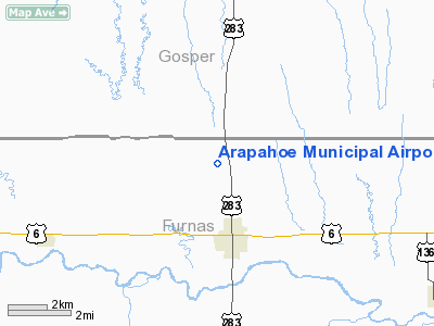
| Arapahoe Municipal Airport |
| IATA: AHF – ICAO: none – FAA LID: 37V |
| Summary |
| Airport type |
Public |
| Owner |
Arapahoe Airport Authority |
| Location |
Arapahoe, Nebraska |
| Elevation AMSL |
2,270 ft / 692 m |
| Coordinates |
40°20′22″N 099°54′23″W / 40.33944°N 99.90639°W / 40.33944; -99.90639 |
| Runways |
| Direction |
Length |
Surface |
| ft |
m |
| 15/33 |
3,000 |
914 |
Asphalt |
| Statistics (2005) |
| Aircraft operations |
2,250 |
| Source: Federal Aviation Administration |
Arapahoe Municipal Airport (IATA: AHF, FAA LID: 37V) is a public airport located two miles (3 km) north of the central business district of Arapahoe, a city in Furnas County, Nebraska, United States. It is owned by the Arapahoe Airport Authority.
Facilities and aircraft
Arapahoe Municipal Airport covers an area of 50 acres (20 ha) which contains one asphalt paved runway (15/33) measuring 3,000 x 50 ft (914 x 15 m). For the 12-month period ending August 2, 2005, the airport had 2,250 aircraft operations, all of which were general aviation.
The above content comes from Wikipedia and is published under free licenses – click here to read more.
Location & QuickFacts
| FAA Information Effective: | 2008-09-25 |
| Airport Identifier: | 37V |
| Airport Status: | Operational |
| Longitude/Latitude: | 099-54-23.4470W/40-20-22.0230N
-99.906513/40.339451 (Estimated) |
| Elevation: | 2270 ft / 691.90 m (Estimated) |
| Land: | 50 acres |
| From nearest city: | 2 nautical miles N of Arapahoe, NE |
| Location: | Furnas County, NE |
| Magnetic Variation: | 08E (1985) |
Owner & Manager
| Ownership: | Publicly owned |
| Owner: | Arapahoe Arpt Authority |
| Address: | Po Box 358
Arapahoe, NE 68922-0358 |
| Phone number: | 308-962-7701 |
| Manager: | Dave Fritz |
| Address: | Po Box 554
Arapahoe, NE 68922-0554 |
| Phone number: | 308-962-9575 |
Airport Operations and Facilities
| Airport Use: | Open to public |
| Wind indicator: | Yes |
| Segmented Circle: | No |
| Control Tower: | No |
| Lighting Schedule: | DUSK-DAWN |
| Beacon Color: | Clear-Green (lighted land airport) |
| Landing fee charge: | No |
| Sectional chart: | Omaha |
| Region: | ACE - Central |
| Boundary ARTCC: | ZDV - Denver |
| Tie-in FSS: | OLU - Columbus |
| FSS on Airport: | No |
| FSS Toll Free: | 1-800-WX-BRIEF |
| NOTAMs Facility: | OLU (NOTAM-d service avaliable) |
Airport Communications
Airport Services
| Fuel available: | 100LL
24 HR SELF SERVICE FUEL AVAILABLE VIA CREDIT CARD SYSTEM. |
| Airframe Repair: | NONE |
| Power Plant Repair: | NONE |
| Bottled Oxygen: | NONE |
| Bulk Oxygen: | NONE |
Runway Information
Runway 15/33
| Dimension: | 3000 x 50 ft / 914.4 x 15.2 m |
| Surface: | ASPH, Good Condition |
| Edge Lights: | Low |
| |
Runway 15 |
Runway 33 |
| Traffic Pattern: | Left | Left |
| Markings: | Basic, Good Condition | Basic, Good Condition |
| Obstruction: | , 50:1 slope to clear | 15 ft road, 600.0 ft from runway, 26:1 slope to clear |
|
Radio Navigation Aids
| ID |
Type |
Name |
Ch |
Freq |
Var |
Dist |
| MCK | FAN MARKER | Mc Cook | | | 11E | 30.8 nm |
| CSB | NDB | Harry Strunk | | 389.00 | 08E | 11.7 nm |
| HDE | NDB | Holdrege | | 396.00 | 07E | 26.7 nm |
| NRN | NDB | Norton | | 230.00 | 08E | 29.1 nm |
| RRX | NDB | Darr | | 326.00 | 07E | 30.4 nm |
| DWL | NDB | Willow | | 353.00 | 08E | 32.9 nm |
| OIN | NDB | Oberlin | | 341.00 | 09E | 42.2 nm |
| PHG | NDB | Phillipsburg | | 368.00 | 08E | 47.5 nm |
| OZB | VOR | Cozad | | 109.00 | 09E | 32.2 nm |
| EAR | VOR | Kearney | | 111.20 | 10E | 47.3 nm |
| MCK | VOR/DME | Mc Cook | 100X | 115.30 | 08E | 32.6 nm |
| HCT | VORTAC | Hayes Center | 124X | 117.70 | 11E | 47.1 nm |
Images and information placed above are from
http://www.airport-data.com/airport/37V/
We thank them for the data!
| General Info
|
| Country |
United States
|
| State |
NEBRASKA
|
| FAA ID |
37V
|
| Latitude |
40-20-22.023N
|
| Longitude |
099-54-23.447W
|
| Elevation |
2270 feet
|
| Near City |
ARAPAHOE
|
We don't guarantee the information is fresh and accurate. The data may
be wrong or outdated.
For more up-to-date information please refer to other sources.
|
|


