|
 |
|
||||
|
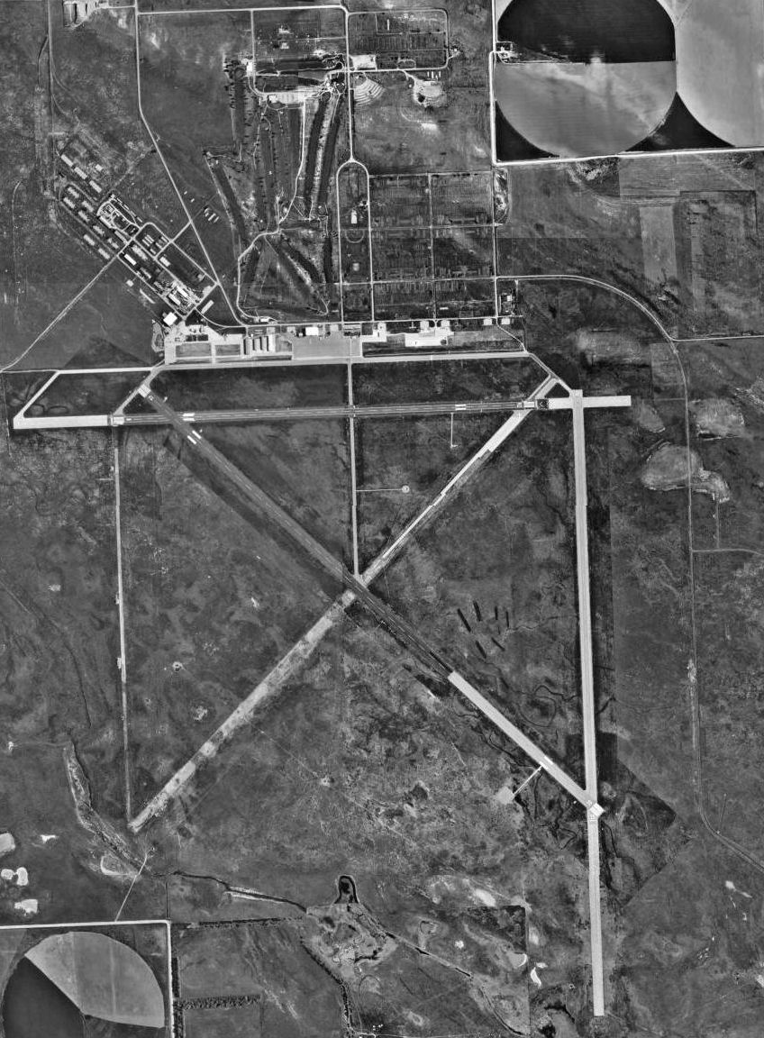
FAA Airport Diagram Alliance Municipal Airport (IATA: AIA, ICAO: KAIA, FAA LID: AIA) is a city-owned public-use airport located three nautical miles (6 km) southeast of the central business district of Alliance, a city in Box Butte County, Nebraska, United States. It is served by one commercial airline, with service subsidized by the Essential Air Service program. HistoryAlliance Municipal Airport was built during World War II by the United States Army Air Force. It was one of eleven United States Army Air Force training airfields in Nebraska during World War II. On 14 April 1942, the Secretary of War authorized the establishment of the field. It was constructed between the summer of 1942 and August 1943. The 4,205-acre (17.02 km) site is bordered by low rolling sandhills to the east, and a wide plain on the north, west and south. Snake Creek flows through the southern section of the property. During the construction of the airfield over 5,000 workers came from all over the country,causing a housing shortage. The population of Alliance doubled almost overnight. Workers moved into garages, store rooms, cellars, attics, and even their own trailers in established parks. Many of the workers were Sioux Indians from the Pine Ridge and Rosebud Reservations, Mexicans from the Southwest, and blacks from Wichita and Kansas City. The cantonment housing area of the airfield covered 1,088 acres (4.40 km), and supported 775 buildings and other structures, including hangars, chapels, warehouses, barracks, mess halls, service buildings, and latrines. Some were built of brick and steel, such as aircraft hangars. However most were of frame construction, sitting on top of poured concrete foundations. Tar paper and plywood were generally used for walls and flooring, as the buildings were considered temporary at best, only to be used for a few years. In addition, the airfield utilized a railroad spur, power plant, waterworks, and sewage system, as well as a total of 35,503 feet (10,821 m) of runways. The airfield had been planned as a training facility for paratroops and air commandos, which needed long runways for C-47 Skytrains to tow gliders. On August 22, 1943, a huge crowd of 65,000 people gathered for the dedication of the newly constructed Alliance Army Airfield. The mission of the airfield was to provide a training facility for Army paratroops and air crews. Between the opening of the airfield and the spring of 1944, the I Troop Carrier Command, 434th Troop Carrier Group commanded the airfield. The 411th Army Air Force Base Unit commanded the support elements at Alliance as part of Air Technical Service Command. In addition to the C-47s, the unit repaired B-17 Flying Fortress and B-24 Liberator aircraft from other airfields. Alliance AAF was divided into air operations, quartermaster, troop cantonment, and gunnery ranges. The airfield was home to as many as 14,000 paratroops in the area, using C-47 Skytrains as powered troop carriers, and CG-3/CG-4 Waco glider troop carriers for their training aircraft. The sandhills were thought to provide a softer landing than wooded areas for jumping paratroops. Known units that trained at Alliance AAF were:
In addition to the USAAF units, the Army 326th Glider Infantry, 507th Parachute Infantry, and 878th Airborne Engineers trained at Alliance before deployment to the European Theater showing the paratroopers how to jump. As paratroopers flooded into Alliance, housing was at a critical shortage. In order to relieve the housing stress, a federal housing project was constructed at the east end of Alliance, consisting of apartment complexes with plain stucco walls, coal heating stoves, and rows of chimneys along the rooflines, thus inspiring the name "Chimney Town." After the paratroops left Alliance, Second Air Force temporarily used the Alliance airfield in the fall of 1944 for the training of B-29 Superfortress crews. Training included teaching the B-29 air crews how to drop bombs and read navigational, aeronautical and bombsight equipment. Finally, in the summer of 1945, the 1st Troop Carrier Command returned to the airfield to train for the proposed invasion of Japan. That necessity ended when Japan surrendered on 6 September. On 31 October 1945, the Army Air Force "temporarily" deactivated the Alliance Army Airfield. Control of the airfield was assigned to Air Technical Service Command at Ogdon Army Airbase, Utah. Though speculation was that the Army would make the huge Alliance airfield a permanent installation, by 20 November the Troop Carrier Command closed the facility permanently and began to make plans to sell the surplus property. By December 1945 the facility was declared surplus property. Nonetheless, its status remained in limbo. The city of Alliance showed interest in acquiring the facility. However, in the fall of 1946 Nebraska congressman A. L. Miller stated that the airfield would be withdrawn from the surplus list to be reactivated for Troop Carrier Command training, in response to strained relations with the Soviet Union. This did not happen, however, and the U. S. Government negotiated a disposition agreement for the facility. Due to disputes between the U.S. government and the city of Alliance, the final disposition of the airfield did not occur for many years, and in the meantime, the government removed the railroad tracks and auctioned off 240 buildings, including lavatories, guard houses and barracks. Finally, on 16 July 1953, the city of Alliance and the federal government finalized the transfer for the land and buildings which were to become the Alliance Municipal Airport. Today a large number of World War II-era buildings remain in use. Facilities and aircraftAlliance Municipal Airport covers an area of 3,500 acres (1,416 ha) which contains three asphalt paved runways: 12/30 measuring 9,202 x 150 ft (46 m). (2,805 x 46 m), 17/35 at 6,311 x 75 ft (23 m). (1,924 x 23 m), and 8/26 at 6,200 x 75 ft (23 m). (1,890 x 23 m). For the 12-month period ending 31 May 2008, the airport had 14,700 aircraft operations, an average of 40 per day: 78% general aviation, 16% scheduled commercial, 3% air taxi and 2% military. At that time there were 58 aircraft based at this airport: 88% single-engine, 5% multi-engine, 2% jet and 6% glider. Airlines and destinations
The above content comes from Wikipedia and is published under free licenses – click here to read more.
Location & QuickFacts
Owner & Manager
Airport Operations and Facilities
Airport Communications
Airport Services
Runway InformationRunway 08/26
Runway 12/30
Runway 17/35
Radio Navigation Aids
Remarks
Images and information placed above are from We thank them for the data!
We don't guarantee the information is fresh and accurate. The data may
be wrong or outdated.
|
|||||||||||||||||||||||||||||||||||||||||||||||||||||||||||||||||||||||||||||||||||||||||||||||||||||||||||||||||||||||||||||||||||||||||||||||||||||||||||||||||||||||||||||||||||||||||||||||||||||||||||||||||||||||||||||||||||||||||||||||||||||||||||||||||||||||||||||||||||||||||||||||||||||||||||||||||||||||||||||||||||||||||||||||||||||||||||||||||||||||||||||||||||||||||||||||||

 |
|
Copyright 2004-2026 © by Airports-Worldwide.com, Vyshenskoho st. 36, Lviv 79010, Ukraine Legal Disclaimer |