 |
|
Wokal Field/glasgow International Airport |
Glasgow Airport
Wokal Field |
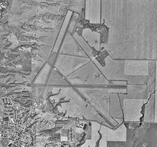 |
| USGS aerial image, 1996 |
| IATA: GGW – ICAO: KGGW – FAA LID: GGW |
| Summary |
| Airport type |
Public |
| Owner |
Glasgow / Valley County |
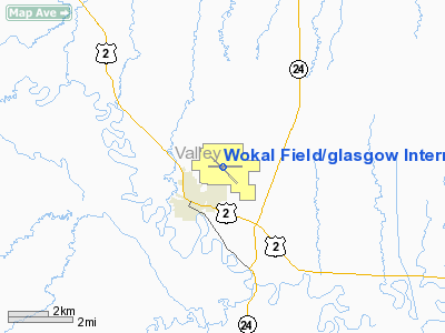
| Serves |
Glasgow, Montana |
| Elevation AMSL |
2,296 ft / 700 m |
| Coordinates |
48°12′45″N 106°36′53″W / 48.2125°N 106.61472°W / 48.2125; -106.61472 |
| Runways |
| Direction |
Length |
Surface |
| ft |
m |
| 12/30 |
5,001 |
1,524 |
Asphalt |
| 8/26 |
5,000 |
1,524 |
Asphalt |
| Statistics (2009) |
| Aircraft operations |
30,010 |
| Based aircraft |
79 |
| Source: Federal Aviation Administration |
Glasgow Airport (IATA: GGW, ICAO: KGGW, TC LID: GGW), also known as Wokal Field/Glasgow International Airport, is a public airport located one nautical mile (1.85 km) northeast of the central business district of Glasgow, a city in Valley County, Montana, United States. This airport is included in the FAA's National Plan of Integrated Airport Systems for 2009–2013, which categorized it as a general aviation facility.
The airport has commercial service on one airline subsidized by the federal Essential Air Service (EAS) program. Great Lakes Airlines provides USDOT EAS service to Glasgow, effective March 2009. History
Glasgow Army Air Field, also known as the Glasgow Satellite Airfield, was activated on 10 November 1942. It was one of three satellite fields of Great Falls Army Air Base which accommodated a bombardment group. There were four Bomber Squadrons within this group, one located at the Great Falls Army Air Base and one at each of the three satellite air fields at Lewistown, Glasgow and Cut Bank.
The 96th Bombardment Squadron of the Second Bombardment Group arrived at Glasgow Army Air Field on 29 November 1942. Heavy bomber squadrons of the time usually consisted of 8 B-17s with 37 officers and 229 enlisted men. The satellite field was used by B-17 bomber crews from the Second Air Force during the second phase of their training. Actual bombing and gunnery training was conducted at the airfield’s associated sites, Glasgow Pattern Bombing Range and the Glasgow Pattern Gunnery Range, though other training sites within the bombardment group were probably also used. The target-towing aircraft assigned to the Fort Peck Aerial Gunnery Range were also stationed at Glasgow. The last unit to complete training at Glasgow Satellite Field was the 614th Bombardment Squadron of the 401st Bombardment Group, which left for England in October 1943.
On 1 December 1944 a German prisoner-of-war camp was established at the site. On 15 July 1946 the Glasgow Army Air Field was classified surplus and it was subsequently transferred to the War Assets Administration on 18 November 1946.
Facilities and aircraft
The airport covers an area of 1,552 acres (628 ha) at an elevation of 2,296 feet (700 m) above mean sea level. It has two asphalt paved runways: 12/30 is 5,001 by 100 feet (1,524 x 30 m) and 8/26 is 5,000 by 75 feet (1,524 x 23 m).
For the 12-month period ending December 31, 2009, the airport had 30,010 aircraft operations, an average of 82 per day: 65% general aviation, 35% air taxi, and <1% military. At that time there were 79 aircraft based at this airport: 92% single-engine, 6% multi-engine, and 1% jet.
Airlines and destinations
| Airlines |
Destinations |
| Great Lakes Airlines |
Billings, Denver, Wolf Point |
The above content comes from Wikipedia and is published under free licenses – click here to read more.
Location & QuickFacts
| FAA Information Effective: | 2008-09-25 |
| Airport Identifier: | GGW |
| Airport Status: | Operational |
| Longitude/Latitude: | 106-36-53.0000W/48-12-45.0000N
-106.614722/48.212500 (Estimated) |
| Elevation: | 2296 ft / 699.82 m (Estimated) |
| Land: | 1552 acres |
| From nearest city: | 1 nautical miles NE of Glasgow, MT |
| Location: | Valley County, MT |
| Magnetic Variation: | 14E (1985) |
Owner & Manager
| Ownership: | Publicly owned |
| Owner: | Glasgow Valley Co |
| Address: | 501 Court Square 14
Glasgow, MT 59230 |
| Phone number: | 406-228-4023 |
| Manager: | Leland Blatter |
| Address: | 100 Airport Rd
Glasgow, MT 59230 |
| Phone number: | 406-228-4023 |
Airport Operations and Facilities
| Airport Use: | Open to public |
| Wind indicator: | Yes
SUPPLEMENTAL WINDCONES LOCATED ON RWYS 26 AND 30. |
| Segmented Circle: | Yes |
| Control Tower: | No |
| Lighting Schedule: | DUSK-DAWN
ACTVT MIRL RYS 08/26 & 12/30, REIL RYS 8,12,26, & 30 - CTAF. VASI RYS 12,26, & 30, & PAPI RY 08 OPER 24 HRS. |
| Beacon Color: | Clear-Green (lighted land airport) |
| Landing fee charge: | No |
| Sectional chart: | Billings |
| Region: | ANM - Northwest Mountain |
| Boundary ARTCC: | ZLC - Salt Lake City |
| Tie-in FSS: | GTF - Great Falls |
| FSS on Airport: | No |
| FSS Toll Free: | 1-800-WX-BRIEF |
| NOTAMs Facility: | GGW (NOTAM-d service avaliable) |
| Federal Agreements: | NGPY3 |
Airport Communications
| CTAF: | 122.800 |
| Unicom: | 122.800 |
Airport Services
| Fuel available: | 100 A1+
AFTER HRS CREDIT CARD FUELING. |
| Airframe Repair: | MAJOR |
| Power Plant Repair: | MAJOR |
| Bottled Oxygen: | NONE |
| Bulk Oxygen: | NONE |
Runway Information
Runway 08/26
| Dimension: | 5000 x 75 ft / 1524.0 x 22.9 m
RY 08/26 1047 FT STOPWAY WEST END.
RY 12/30 230 FT STOPWAY NW END. |
| Surface: | ASPH, Good Condition |
| Surface Treatment: | Saw-cut or plastic Grooved |
| Weight Limit: | Single wheel: 25000 lbs.
Dual wheel: 45000 lbs.
Dual tandem wheel: 75000 lbs. |
| Edge Lights: | Medium |
| |
Runway 08 |
Runway 26 |
| Longitude: | 106-37-28.9620W | 106-36-15.1390W |
| Latitude: | 48-12-46.1400N | 48-12-46.2370N |
| Elevation: | 2282.00 ft | 2293.00 ft |
| Alignment: | 90 | 127 |
| Traffic Pattern: | Left | Left |
| Markings: | Basic, Good Condition | Basic, Good Condition |
| Crossing Height: | 30.00 ft | 26.00 ft |
| VASI: | 2-light PAPI on left side | 2-box on left side |
| Visual Glide Angle: | 3.00° | 3.00° |
| Runway End Identifier: | Yes | Yes |
| Decleard distances: | | Take off run available 5000.00 ft
Take off distance available 5000.00 ft
Actual stop distance available 6047.00 ft
Landing distance available 5000.00 ft
|
|
Runway 12/30
| Dimension: | 5001 x 100 ft / 1524.3 x 30.5 m
RY 08/26 1047 FT STOPWAY WEST END.
RY 12/30 230 FT STOPWAY NW END. |
| Surface: | ASPH, Good Condition |
| Surface Treatment: | Aggregate Friction Seal Coat |
| Weight Limit: | Single wheel: 55000 lbs.
Dual wheel: 70000 lbs.
Dual tandem wheel: 100000 lbs. |
| Edge Lights: | Medium |
| |
Runway 12 |
Runway 30 |
| Longitude: | 106-37-21.0450W | 106-36-27.8490W |
| Latitude: | 48-13-00.5920N | 48-12-26.3670N |
| Elevation: | 2288.00 ft | 2282.00 ft |
| Alignment: | 127 | 127 |
| Traffic Pattern: | Left | Left |
| Markings: | Non-precision instrument, Fair Condition
RWYS 12 /30 AND 8/26 HAVE DISTANCE TO GO SIGNS; RYS 12/30 & 08/26 HAVE RY SIDESTRIPE MARKERS. | Non-precision instrument, Fair Condition |
| Crossing Height: | 38.00 ft | 40.00 ft |
| VASI: | 4-box on left side | 4-box on left side |
| Visual Glide Angle: | 3.00° | 3.00° |
| Runway End Identifier: | Yes | Yes |
| Decleard distances: | | Take off run available 5001.00 ft
Take off distance available 5001.00 ft
Actual stop distance available 5231.00 ft
Landing distance available 5001.00 ft
|
|
Radio Navigation Aids
| ID |
Type |
Name |
Ch |
Freq |
Var |
Dist |
| MKR | NDB | Milk River | | 339.00 | 14E | 0.5 nm |
| OLF | NDB | Wolf Point | | 404.00 | 11E | 41.1 nm |
| GGW | VOR/DME | Glasgow | 086X | 113.90 | 14E | 0.5 nm |
Images and information placed above are from
http://www.airport-data.com/airport/GGW/
We thank them for the data!
| General Info
|
| Country |
United States
|
| State |
MONTANA
|
| FAA ID |
GGW
|
| Latitude |
48-12-44.871N
|
| Longitude |
106-36-53.363W
|
| Elevation |
2294 feet
|
| Near City |
GLASGOW
|
We don't guarantee the information is fresh and accurate. The data may
be wrong or outdated.
For more up-to-date information please refer to other sources.
|
|


