 |
|
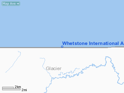
Whetstone International Airport |
Del Bonita/Whetstone International Airport
Whetstone International Airport |
| IATA: none – ICAO: none – FAA LID: H28 – TC LID: CEQ4 |
| Summary |
| Airport type |
Public |
| Owner |
State of Montana |
| Operator |
Montana Aeronautics Division |
| Serves |
Del Bonita, Alberta
Port of Del Bonita, Montana |
| Location |
Canada – United States border |
| Elevation AMSL |
4,335 ft / 1,321 m
4,336 ft / 1,322 m |
| Coordinates |
48°59′55″N 112°46′35″W / 48.99861°N 112.77639°W / 48.99861; -112.77639 (Del Bonita/Whetstone International Airport)
48°59′59.9″N 112°47′33″W / 48.999972°N 112.7925°W / 48.999972; -112.7925 (Whetstone International Airport) |
| Runways |
| Direction |
Length |
Surface |
| ft |
m |
| 07/25 |
4,363
4,440 |
1,330
1,353 |
Turf |
| Source: Canada Flight Supplement and Federal Aviation Administration |
Del Bonita/Whetstone International Airport (FAA LID: H28, TC LID: CEQ4) is located 2 nautical miles (3.7 km; 2.3 mi) south of Del Bonita, Alberta, on the Canada – United States border at Port of Del Bonita, Montana.
Whetstone International Airport is owned by the U.S. state of Montana and operated by the Montana Aeronautics Division. It has a runway located on the Canadian border, with aircraft tie down areas in Canada and the United States. The airport is 31 miles (50 km) northwest of the city of Cut Bank, Montana.
The airport is classified as an airport of entry by NAV CANADA and is staffed by the Canada Border Services Agency. CBSA officers at this airport currently can handle general aviation aircraft only, with no more than 15 passengers.
Facilities and aircraft
The airport covers an area of 14 acres (5.7 ha) at an elevation of 4,336 feet (1,322 m) above mean sea level. It has one runway designated 7/25 with a turf surface measuring 4,440 by 65 feet (1,353 x 20 m). For the 12-month period ending August 23, 2008, the airport had 60 general aviation aircraft operations, an average of 5 per month.
The above content comes from Wikipedia and is published under free licenses – click here to read more.
Location & QuickFacts
| FAA Information Effective: | 2008-09-25 |
| Airport Identifier: | H28 |
| Airport Status: | Operational |
| Longitude/Latitude: | 112-47-33.2910W/48-59-59.9630N
-112.792581/48.999990 (Estimated) |
| Elevation: | 4336 ft / 1321.61 m (Estimated) |
| Land: | 14 acres |
| From nearest city: | 0 nautical miles W of Port Of Del Bonita, MT |
| Location: | Glacier County, MT |
| Magnetic Variation: | 18E (1985) |
Owner & Manager
| Ownership: | Publicly owned |
| Owner: | Montana Aeronautics Division |
| Address: | Po Box 200507
Helena, MT 59620 |
| Phone number: | 406-444-2506 |
| Manager: | Montana Aeronautics Division |
| Address: | Po Box 200507
Helena, MT 59620 |
| Phone number: | 406-444-2506 |
Airport Operations and Facilities
| Airport Use: | Open to public |
| Wind indicator: | Yes |
| Segmented Circle: | No |
| Control Tower: | No |
| Landing fee charge: | No |
| Sectional chart: | Great Falls |
| Region: | ANM - Northwest Mountain |
| Boundary ARTCC: | ZLC - Salt Lake City |
| Tie-in FSS: | GTF - Great Falls |
| FSS Toll Free: | 1-800-WX-BRIEF |
| NOTAMs Facility: | GTF (NOTAM-d service avaliable) |
Airport Communications
| CTAF: | 122.800 |
| Unicom: | 122.800
UNICOM LOCATED IN CUSTOMS OFFICE. |
Airport Services
Runway Information
Runway 07/25
| Dimension: | 4440 x 65 ft / 1353.3 x 19.8 m |
| Surface: | TURF, Fair Condition
RWY 07/25 GOPHER HOLES AND LARGE BADGER HOLES ON RY SURFACE. |
| |
Runway 07 |
Runway 25 |
| Traffic Pattern: | Left | Left |
| Obstruction: | 25 ft pline, 207.0 ft from runway, 62 ft right of centerline, 8:1 slope to clear | 5 ft fence, 200.0 ft from runway, 40:1 slope to clear |
|
Radio Navigation Aids
| ID |
Type |
Name |
Ch |
Freq |
Var |
Dist |
| QL | NDB | Lethbridge | | 248.00 | 18E | 36.6 nm |
| SBX | NDB | Shelby | | 347.00 | 18E | 46.0 nm |
| YQL | VOR/DME | Lethbridge | 104X | 115.70 | 18E | 38.4 nm |
| CTB | VORTAC | Cut Bank | 091X | 114.40 | 17E | 31.6 nm |
Remarks
- NO SNOW REMOVAL.
- RY 07/25 +4' FENCE FULL RY LENGTH & PARALLEL TO RY, 44' LEFT & RIGHT.
- FILED FOR RECORD PURPOSES ONLY.
Images and information placed above are from
http://www.airport-data.com/airport/H28/
We thank them for the data!
| General Info
|
| Country |
United States
|
| State |
MONTANA
|
| FAA ID |
H28
|
| Latitude |
48-59-59.963N
|
| Longitude |
112-47-33.291W
|
| Elevation |
4336 feet
|
| Near City |
PORT OF DEL BONITA
|
We don't guarantee the information is fresh and accurate. The data may
be wrong or outdated.
For more up-to-date information please refer to other sources.
|
|


