 |
|
Location & QuickFacts
| FAA Information Effective: | 2008-09-25 |
| Airport Identifier: | 2MT6 |
| Airport Status: | Operational |
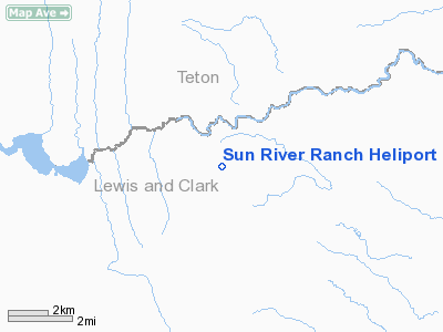
| Longitude/Latitude: | 112-40-19.0000W/47-36-00.0000N
-112.671944/47.600000 (Estimated) |
| Elevation: | 4450 ft / 1356.36 m (Estimated) |
| Land: | 5 acres |
| From nearest city: | 18 nautical miles NW of Augusta, MT |
| Location: | Lewis And Clark County, MT |
| Magnetic Variation: | () |
Owner & Manager
| Ownership: | Privately owned |
| Owner: | Larry Wilson |
| Address: | 1015 Eastman Drive
Big Fork, MT 59911 |
| Phone number: | 406-837-5360 |
| Manager: | Doug Wilkey |
| Address: | 665 Lang Creek Rd
Marion, MT 59925 |
| Phone number: | 406-858-2332 |
Airport Operations and Facilities
| Airport Use: | Private |
| Wind indicator: | Yes |
| Segmented Circle: | No |
| Control Tower: | No |
| Sectional chart: | Great Falls |
| Region: | ANM - Northwest Mountain |
| Boundary ARTCC: | ZLC - Salt Lake City |
| Tie-in FSS: | GTF - Great Falls |
| FSS Toll Free: | 1-800-WX-BRIEF |
Runway Information
Helipad H1
| Dimension: | 75 x 75 ft / 22.9 x 22.9 m |
| Surface: | CONC, |
| |
Runway H1 |
Runway |
| Traffic Pattern: | Left | Left |
|
Radio Navigation Aids
| ID |
Type |
Name |
Ch |
Freq |
Var |
Dist |
| CII | NDB | Choteau | | 269.00 | 17E | 24.3 nm |
| CRD | NDB | Conrad | | 293.00 | 17E | 46.6 nm |
Images and information placed above are from
http://www.airport-data.com/airport/2MT6/
We thank them for the data!
We don't guarantee the information is fresh and accurate. The data may
be wrong or outdated.
For more up-to-date information please refer to other sources.
|
|


