 |
|
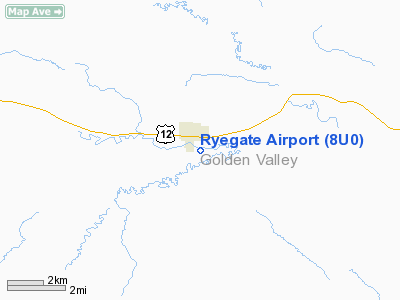
Location & QuickFacts
| FAA Information Effective: | 2008-09-25 |
| Airport Identifier: | 8U0 |
| Airport Status: | Operational |
| Longitude/Latitude: | 109-14-51.6000W/46-17-25.8000N
-109.247667/46.290500 (Estimated) |
| Elevation: | 3689 ft / 1124.41 m (Estimated) |
| Land: | 42 acres |
| From nearest city: | 1 nautical miles S of Ryegate, MT |
| Location: | Golden Valley County, MT |
| Magnetic Variation: | 15E (1985) |
Owner & Manager
| Ownership: | Publicly owned |
| Owner: | State Of Montana |
| Address: | Po Box 200507
Helena, MT 59620-0507 |
| Phone number: | 406-444-2506 |
| Manager: | Mt Aeronautics Division |
| Address: | Box 200507
Helena, MT 59620-0507 |
| Phone number: | 406-444-2506 |
Airport Operations and Facilities
| Airport Use: | Open to public |
| Wind indicator: | Yes |
| Segmented Circle: | Yes |
| Control Tower: | No |
| Lighting Schedule: | DUSK-DAWN |
| Beacon Color: | Clear (unlighted land airport)
ROTG BCN LCTD ATOP 51 FT TWR 1100 FT W OF RY 07/25 END & 900 FT S OF EXTNDD CNTRLN. |
| Landing fee charge: | No |
| Sectional chart: | Great Falls |
| Region: | ANM - Northwest Mountain |
| Boundary ARTCC: | ZLC - Salt Lake City |
| Tie-in FSS: | GTF - Great Falls |
| FSS on Airport: | No |
| FSS Toll Free: | 1-800-WX-BRIEF |
| NOTAMs Facility: | GTF (NOTAM-d service avaliable) |
Airport Communications
Airport Services
| Airframe Repair: | NONE |
| Power Plant Repair: | NONE |
| Bottled Oxygen: | NONE |
| Bulk Oxygen: | NONE |
Runway Information
Runway 07/25
| Dimension: | 3440 x 100 ft / 1048.5 x 30.5 m |
| Surface: | TURF, Fair Condition
SFC COND ROUGH. |
| |
Runway 07 |
Runway 25 |
| Traffic Pattern: | Left | Left |
| Obstruction: | 30 ft pline, 875.0 ft from runway, 29:1 slope to clear | 100 ft bluff, 3200.0 ft from runway, 400 ft left of centerline, 32:1 slope to clear |
|
Radio Navigation Aids
| ID |
Type |
Name |
Ch |
Freq |
Var |
Dist |
| HWQ | NDB | Harlowton | | 242.00 | 17E | 25.8 nm |
| RPX | NDB | Roundup | | 362.00 | 17E | 30.4 nm |
| LWT | NDB | Lewistown | | 353.00 | 17E | 48.2 nm |
| BIL | VORTAC | Billings | 092X | 114.50 | 14E | 38.9 nm |
| LWT | VORTAC | Lewistown | 057X | 112.00 | 15E | 48.2 nm |
Remarks
Images and information placed above are from
http://www.airport-data.com/airport/8U0/
We thank them for the data!
| General Info
|
| Country |
United States
|
| State |
MONTANA
|
| FAA ID |
8U0
|
| Latitude |
46-17-25.800N
|
| Longitude |
109-14-51.600W
|
| Elevation |
3689 feet
|
| Near City |
RYEGATE
|
We don't guarantee the information is fresh and accurate. The data may
be wrong or outdated.
For more up-to-date information please refer to other sources.
|
|


