 |
|
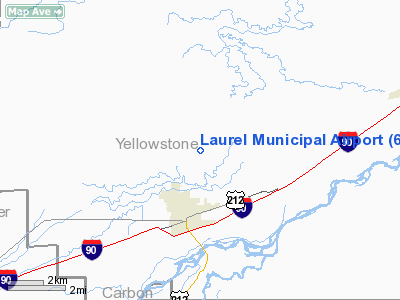
| Laurel Municipal Airport |
 |
| IATA: none – ICAO: 6S8 – FAA LID: 6S8 |
| Summary |
| Airport type |
Public |
| Owner |
Yellowstone County Airport Authority |
| Operator |
Yellowstone County |
| Serves |
Laurel & Billings |
| Location |
Laurel, Montana |
| Elevation AMSL |
3517 ft / 1071.9 m |
| Coordinates |
45°42′15″N 108°45′33″W / 45.70417°N 108.75917°W / 45.70417; -108.75917Coordinates: 45°42′15″N 108°45′33″W / 45.70417°N 108.75917°W / 45.70417; -108.75917 |
| Runways |
| Direction |
Length |
Surface |
| ft |
m |
| 4/22 |
5,200 |
1584.9 |
Asphalt |
| 14/32 |
2,209 |
673.3 |
Asphalt |
| 9/27 |
1,100 |
335.2 |
Turf |
| Source: Federal Aviation Administration AirNav |
Laurel Municipal Airport (ICAO: 6S8) is a publicly-owned public-use airport in Laurel, Montana, which is located eleven miles (17 km) southwest of the central business district (CBD) of Billings, Montana, a city in Yellowstone County, Montana, USA. The airport has three runways exclusively serving privately-operated general aviation aircraft and helicopters with no scheduled commercial service.
Facilities
Laurel Municipal Airport covers 254 acres and has three runways:
- Runway 4/22: 5200 × 75 ft. / 1585 × 23 m, Surface: Asphalt
- Runway 14/32: 2209 × 50 ft. / 673 × 15 m, Surface: Asphalt
- Runway 9/27: 1100 × 60 ft. / 335 × 18 m, Surface: Turf
- Northern Skies Aviation is the sole Fixed Base Operator located at the airport.
The above content comes from Wikipedia and is published under free licenses – click here to read more.
Location & QuickFacts
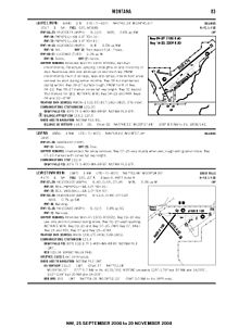
| FAA Information Effective: | 2008-09-25 |
| Airport Identifier: | 6S8 |
| Airport Status: | Operational |
| Longitude/Latitude: | 108-45-39.9190W/45-42-11.1180N
-108.761089/45.703088 (Estimated) |
| Elevation: | 3517 ft / 1071.98 m (Surveyed) |
| Land: | 254 acres |
| From nearest city: | 2 nautical miles N of Laurel, MT |
| Location: | Yellowstone County, MT |
| Magnetic Variation: | 14E (1990) |
Owner & Manager
| Ownership: | Publicly owned |
| Owner: | Airport Authority |
| Address: | Box 242
Laurel, MT 59044 |
| Manager: | John Smith |
| Address: | 419 West 8th
Laurel, MT 59044 |
| Phone number: | 406-628-4595 |
Airport Operations and Facilities
| Airport Use: | Open to public |
| Wind indicator: | Yes |
| Segmented Circle: | Yes |
| Control Tower: | No |
| Lighting Schedule: | DUSK-DAWN
ACTVT MIRL RY 04/22 & PAPI RYS 04 & 22 - CTAF. |
| Beacon Color: | Clear-Green (lighted land airport) |
| Landing fee charge: | No |
| Sectional chart: | Billings |
| Region: | ANM - Northwest Mountain |
| Boundary ARTCC: | ZLC - Salt Lake City |
| Tie-in FSS: | GTF - Great Falls |
| FSS on Airport: | No |
| FSS Toll Free: | 1-800-WX-BRIEF |
| NOTAMs Facility: | GTF (NOTAM-d service avaliable) |
| Federal Agreements: | NGY |
Airport Communications
| CTAF: | 123.050 |
| Unicom: | 123.050
AUTOMATED UNICOM. |
Airport Services
| Fuel available: | 100 MOGAS |
| Airframe Repair: | MAJOR |
| Power Plant Repair: | MAJOR |
| Bottled Oxygen: | NONE |
| Bulk Oxygen: | NONE |
Runway Information
Runway 04/22
| Dimension: | 5200 x 75 ft / 1585.0 x 22.9 m |
| Surface: | ASPH, Fair Condition
SURFACE ROUGH. |
| Weight Limit: | Single wheel: 12500 lbs. |
| Edge Lights: | Medium |
| |
Runway 04 |
Runway 22 |
| Longitude: | 108-45-50.2920W | 108-44-53.9530W |
| Latitude: | 45-42-05.8510N | 45-42-38.6630N |
| Elevation: | 3488.00 ft | 3454.00 ft |
| Alignment: | 50 | 127 |
| Traffic Pattern: | Left | Left |
| Markings: | Non-precision instrument, Good Condition | Non-precision instrument, Good Condition |
| Crossing Height: | 31.00 ft | 41.00 ft |
| VASI: | 2-light PAPI on left side | 2-light PAPI on left side |
| Visual Glide Angle: | 3.00° | 3.00° |
|
Runway 09/27
| Dimension: | 1100 x 60 ft / 335.3 x 18.3 m |
| Surface: | TURF, Fair Condition
SURFACE ROUGH. |
| |
Runway 09 |
Runway 27 |
| Longitude: | 108-45-58.7490W | 108-45-43.4210W |
| Latitude: | 45-42-16.0240N | 45-42-14.4250N |
| Elevation: | 3517.00 ft | 3492.00 ft |
| Alignment: | 98 | 127 |
| Traffic Pattern: | Left | Left |
| Obstruction: | 4 ft fence, 80.0 ft from runway, 59 ft left of centerline, 20:1 slope to clear | 4 ft fence, 80.0 ft from runway, 20:1 slope to clear |
|
Runway 14/32
| Dimension: | 2209 x 50 ft / 673.3 x 15.2 m |
| Surface: | ASPH, Poor Condition
SURFACE ROUGH. |
| Weight Limit: | Single wheel: 8000 lbs. |
| |
Runway 14 |
Runway 32 |
| Longitude: | 108-45-59.4980W | 108-45-45.0050W |
| Latitude: | 45-42-15.4590N | 45-41-56.1620N |
| Elevation: | 3517.00 ft | 3462.00 ft |
| Alignment: | 127 | 127 |
| Traffic Pattern: | Left | Left |
| Markings: | Basic, Good Condition | Basic, Good Condition |
| Displaced threshold: | 0.00 ft | 514.00 ft
DSPLCD THR MKD NOT LGTD. |
| Obstruction: | 192 ft hill, 5000.0 ft from runway, 25:1 slope to clear | 35 ft trees, 258.0 ft from runway, 1:1 slope to clear
APCH SLOPE 22:1 TO DSPLCD THR. |
|
Radio Navigation Aids
| ID |
Type |
Name |
Ch |
Freq |
Var |
Dist |
| RED | NDB | Red Lodge | | 203.00 | 17E | 35.0 nm |
| RPX | NDB | Roundup | | 362.00 | 17E | 47.4 nm |
| HCY | NDB | Cowley | | 257.00 | 14E | 49.3 nm |
| BIL | VORTAC | Billings | 092X | 114.50 | 14E | 8.5 nm |
Remarks
- INTERMITTENT SNOW REMOVAL - BE ALERT DURG WINTER MONTHS.
- PAEW N OF RY 04/22.
- NUMEROUS DEER AND ANTELOPE ON AND INVOF OF RY.
- PAEW INTERMITTENTLY IN THE VICINITY OF ALL RYS, TWYS AND RAMPS.
- RY 09 NOT MAINTAINED DURG WINTER.
Images and information placed above are from
http://www.airport-data.com/airport/6S8/
We thank them for the data!
| General Info
|
| Country |
United States
|
| State |
MONTANA
|
| FAA ID |
6S8
|
| Latitude |
45-42-11.118N
|
| Longitude |
108-45-39.919W
|
| Elevation |
3517 feet
|
| Near City |
LAUREL
|
We don't guarantee the information is fresh and accurate. The data may
be wrong or outdated.
For more up-to-date information please refer to other sources.
|
|


