 |
|
| L. M. Clayton Airport |
| IATA: OLF – ICAO: KOLF – FAA LID: OLF |
| Summary |
| Airport type |
Public |
| Owner |
City of Wolf Point & Roosevelt County |
| Serves |
Wolf Point, Montana |
| Elevation AMSL |
1,986 ft / 605 m |
| Coordinates |
48°05′40″N 105°34′30″W / 48.09444°N 105.575°W / 48.09444; -105.575 |
| Runways |
| Direction |
Length |
Surface |
| ft |
m |
| 11/29 |
5,089 |
1,551 |
Asphalt |
| Statistics (2009) |
| Aircraft operations |
5,105 |
| Source: Federal Aviation Administration |
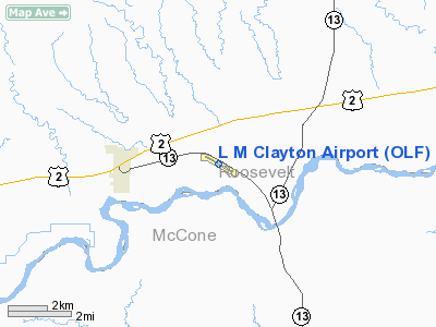
L. M. Clayton Airport (IATA: OLF, ICAO: KOLF, FAA LID: OLF) is a public-use airport located three nautical miles (6 km) northeast of the central business district of Wolf Point, a city in Roosevelt County, Montana, United States. It is owned by the City of Wolf Point and Roosevelt County. This airport is included in the FAA's National Plan of Integrated Airport Systems for 2009–2013, which categorized it as a general aviation facility. It is also designated to receive commercial service subsidized by the federal Essential Air Service (EAS) program. Reportedly, this made L. M. Clayton Airport the smallest airport in the 48 contiguous states with regularly scheduled air service.
Scheduled air service at Wolf Point ended on March 8, 2008, when Big Sky Airlines (the designated EAS operator) ceased operation. Great Lakes Airlines has been given USDOT approval to take over EAS service between Wolf Point and Billings, Montana. Facilities and aircraft
L. M. Clayton Airport covers an area of 290 acres (117 ha) at an elevation of 1,986 feet (605 m) above mean sea level. It has one runway designated 11/29 with an asphalt surface measuring 5,089 by 100 feet (1,551 x 30 m). For the 12-month period ending December 31, 2009, the airport had 5,105 aircraft operations, an average of 13 per day: 55% air taxi and 45% general aviation.
Airlines and destinations
| Airlines |
Destinations |
| Great Lakes Airlines |
Billings, Glasgow |
The above content comes from Wikipedia and is published under free licenses – click here to read more.
Location & QuickFacts
| FAA Information Effective: | 2008-09-25 |
| Airport Identifier: | OLF |
| Airport Status: | Operational |
| Longitude/Latitude: | 105-34-30.1930W/48-05-40.2640N
-105.575054/48.094518 (Estimated) |
| Elevation: | 1986 ft / 605.33 m (Surveyed) |
| Land: | 290 acres |
| From nearest city: | 3 nautical miles NE of Wolf Point, MT |
| Location: | Roosevelt County, MT |
| Magnetic Variation: | 11E (2005) |
Owner & Manager
| Ownership: | Publicly owned |
| Owner: | City Of Wolf Point-roosevelt County |
| Address: | 201 4th Ave South
Wolf Point, MT 59201 |
| Phone number: | 406-653-1852 |
| Manager: | Richard Isle |
| Address: | 201 4th Ave South
Wolf Point, MT 59201 |
| Phone number: | 406-653-1852 |
Airport Operations and Facilities
| Airport Use: | Open to public |
| Wind indicator: | Yes |
| Segmented Circle: | Yes |
| Control Tower: | No |
| Lighting Schedule: | DUSK-DAWN
ACTVT MIRL RY 11/29, REIL RYS 11 & 29, & VASI RYS 11 & 29 - CTAF. |
| Beacon Color: | Clear-Green (lighted land airport) |
| Landing fee charge: | No |
| Sectional chart: | Billings |
| Region: | ANM - Northwest Mountain |
| Traffic Pattern Alt: | 800 ft |
| Boundary ARTCC: | ZLC - Salt Lake City |
| Tie-in FSS: | GTF - Great Falls |
| FSS on Airport: | No |
| FSS Toll Free: | 1-800-WX-BRIEF |
| NOTAMs Facility: | OLF (NOTAM-d service avaliable) |
| Certification type/date: | III A S 12/20 |
| Federal Agreements: | NGY |
Airport Communications
| CTAF: | 122.800 |
| Unicom: | 122.800 |
Airport Services
| Fuel available: | 100LLA
24 HR SELF SVC CREDIT CARD FUEL FAC. |
| Airframe Repair: | MAJOR |
| Power Plant Repair: | MAJOR |
| Bottled Oxygen: | NONE |
| Bulk Oxygen: | NONE |
Runway Information
Runway 11/29
| Dimension: | 5089 x 100 ft / 1551.1 x 30.5 m |
| Surface: | ASPH, Fair Condition |
| Surface Treatment: | Porous Friction Course |
| Weight Limit: | Single wheel: 38000 lbs.
Dual wheel: 50000 lbs. |
| Edge Lights: | Medium |
| |
Runway 11 |
Runway 29 |
| Longitude: | 105-35-02.6380W | 105-33-57.7240W |
| Latitude: | 48-05-52.7690N | 48-05-27.6730N |
| Elevation: | 1984.00 ft | 1983.00 ft |
| Alignment: | 120 | 127 |
| Traffic Pattern: | Left | Left |
| Markings: | Non-precision instrument, Fair Condition | Non-precision instrument, Fair Condition |
| Crossing Height: | 25.00 ft | 25.00 ft |
| VASI: | 2-box on left side | 2-box on left side |
| Visual Glide Angle: | 3.00° | 3.00° |
| Runway End Identifier: | Yes | Yes |
| Obstruction: | 16 ft road, 580.0 ft from runway, 23:1 slope to clear | , 50:1 slope to clear |
|
Radio Navigation Aids
| ID |
Type |
Name |
Ch |
Freq |
Var |
Dist |
| OLF | NDB | Wolf Point | | 404.00 | 11E | 1.2 nm |
| CRR | NDB | Circle | | 245.00 | 15E | 40.6 nm |
| MKR | NDB | Milk River | | 339.00 | 14E | 42.7 nm |
| SCO | NDB | Scobey | | 283.00 | 16E | 43.3 nm |
| GGW | VOR/DME | Glasgow | 086X | 113.90 | 14E | 42.7 nm |
Images and information placed above are from
http://www.airport-data.com/airport/OLF/
We thank them for the data!
| General Info
|
| Country |
United States
|
| State |
MONTANA
|
| FAA ID |
OLF
|
| Latitude |
48-05-40.264N
|
| Longitude |
105-34-30.193W
|
| Elevation |
1986 feet
|
| Near City |
WOLF POINT
|
We don't guarantee the information is fresh and accurate. The data may
be wrong or outdated.
For more up-to-date information please refer to other sources.
|
|


