 |
|
Great Falls International Airport |
| Great Falls International Airport |
 |
| IATA: GTF – ICAO: KGTF |
| Summary |
| Airport type |
Public |
| Operator |
Great Falls International Airport Authority |
| Serves |
Great Falls, Montana |
| Location |
Great Falls, Montana |
| Elevation AMSL |
3,680 ft / 1,121.7 m |
| Coordinates |
47°28′55.20″N 111°22′14.46″W / 47.482°N 111.3706833°W / 47.482; -111.3706833 |
| Website |
http://www.gtfairport.com |
| Runways |
| Direction |
Length |
Surface |
| ft |
m |
| 3/21 |
10,502 |
3,201 |
Asphalt |
| 16/34 |
5,722 |
1,744 |
Asphalt |
| 7/25 |
4,294 |
1,309 |
Asphalt |
| Statistics (2006) |
| Enplanments |
142,051 |
| Tower Operations |
45,737 |
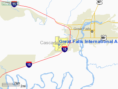
Great Falls International Airport (IATA: GTF, ICAO: KGTF) is a joint civil-military public airport located within city limits, three miles (5 km) southwest of central Great Falls in Cascade County, Montana, USA. GTF serves the Great Falls area, as well as other communities throughout central Montana.
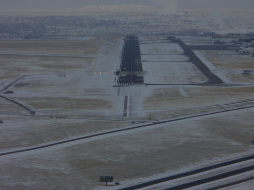 | |
On final approach for Runway 3 at GTF International Airport. |
Great Falls International Airport is also home to Great Falls Air National Guard Base and the Montana Air National Guard's 120th Fighter Wing (120 FW), the "Vigilantes." An Air National Guard unit operationally-gained by the Air Combat Command (ACC), the 120 FW transitioned from the F-16C Fighting Falcon to the F-15C Eagle in January 2009, which it employs in the air defense and air dominance missions.
Malmstrom Air Force Base, home of the 341st Missile Wing (341 MW) of the Air Force Global Strike Command (AFGSC), is located 10 miles east of GTF, on the east side of Great Falls. With the transfer of its previously assigned KC-135 aircraft in the 1990s, Malmstrom's 12,000 foot runway is currently closed to fixed-wing traffic and open only to military helicopters. As a result, Great Falls ANGB provides support for transient fixed-wing military aircraft visiting Malmstrom AFB. History
Great Falls International Airport was initiated in November 1928 following a recommendation from the U.S. Department of Commerce. The airport was leased by the U.S. War Department during World War II and became a home for the 7th Ferrying Command of the U.S. Army Air Forces during the war. During the war years, more than 7,500 bombers and fighter aircraft passed through Great Falls on their way to the war fronts in Europe and the Pacific. While using the airport as an air base, the U.S. Army acquired an additional 740 acres of land and built many buildings and other facilities. The airport remained under government control until June 1948, at which point the newly-established Department of Defense deeded the airport back to the City of Great Falls with the stipulation that the facility could revert to military control in the event of a national emergency. The airport was released from this clause in 1961. In 1975, the terminal at Great Falls International Airport was replaced and all runways, aprons, and taxiways updated. With the use of Federal Aviation Administration matching funds, the Great Falls International Airport Authority performs annual operations, maintenance, and capital improvements.
Airlines and destinations
| Airlines |
Destinations |
| Allegiant Air |
Las Vegas, Phoenix/Mesa |
| Delta Connection operated by Compass Airlines |
Minneapolis/St. Paul |
| Delta Connection operated by SkyWest Airlines |
Salt Lake City |
| Horizon Air |
Helena, Seattle/Tacoma |
| United Express operated by SkyWest Airlines |
Denver |
Cargo Carriers
- Alpine Air
- Ameriflight
- Empire Air
- FedEx Express
The above content comes from Wikipedia and is published under free licenses – click here to read more.
Location & QuickFacts
| FAA Information Effective: | 2008-09-25 |
| Airport Identifier: | GTF |
| Airport Status: | Operational |
| Longitude/Latitude: | 111-22-14.1961W/47-28-57.5541N
-111.370610/47.482654 (Estimated) |
| Elevation: | 3680 ft / 1121.66 m (Surveyed) |
| Land: | 2316 acres |
| From nearest city: | 3 nautical miles SW of Great Falls, MT |
| Location: | Cascade County, MT |
| Magnetic Variation: | 16E (1990) |
Owner & Manager
| Ownership: | Publicly owned |
| Owner: | Great Falls Intl Arpt Auth |
| Address: | 2800 Terminal Dr
Great Falls, MT 59404-5599 |
| Phone number: | 406-727-3404 |
| Manager: | Cynthia C Schultz |
| Address: | 2800 Terminal Drive
Great Falls, MT 59404-5599 |
| Phone number: | 406-727-3404 |
Airport Operations and Facilities
| Airport Use: | Open to public |
| Wind indicator: | Yes |
| Segmented Circle: | Yes |
| Control Tower: | Yes |
| Lighting Schedule: | DUSK-DAWN |
| Beacon Color: | Clear-Green (lighted land airport) |
| Landing fee charge: | No |
| Sectional chart: | Great Falls |
| Region: | ANM - Northwest Mountain |
| Traffic Pattern Alt: | 800 ft |
| Boundary ARTCC: | ZLC - Salt Lake City |
| Tie-in FSS: | GTF - Great Falls |
| FSS on Airport: | No |
| FSS Toll Free: | 1-800-WX-BRIEF |
| NOTAMs Facility: | GTF (NOTAM-d service avaliable) |
| Certification type/date: | I C S 05/1973 |
| Federal Agreements: | NGPY3 |
Airport Communications
Airport Services
| Fuel available: | 100LLA |
| Airframe Repair: | MAJOR |
| Power Plant Repair: | MAJOR |
| Bottled Oxygen: | HIGH/LOW |
| Bulk Oxygen: | HIGH/LOW |
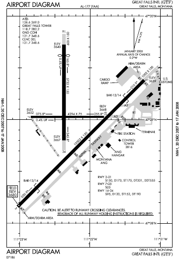
Runway Information
Runway 03/21
| Dimension: | 10502 x 150 ft / 3201.0 x 45.7 m |
| Surface: | ASPH, Good Condition |
| Surface Treatment: | Saw-cut or plastic Grooved |
| Weight Limit: | Single wheel: 150000 lbs.
Dual wheel: 173000 lbs.
Dual tandem wheel: 331000 lbs.
Dual dual tandem wheel: 555000 lbs.
FOR DC-10-40 AND B747. |
| Edge Lights: | High |
| |
Runway 03 |
Runway 21 |
| Longitude: | 111-23-01.7822W | 111-21-13.6648W |
| Latitude: | 47-28-09.6335N | 47-29-22.8935N |
| Elevation: | 3680.00 ft | 3659.00 ft |
| Alignment: | 45 | 127 |
| ILS Type: | ILS/DME
| |
| Traffic Pattern: | Left | Left |
| Markings: | Precision instrument, Good Condition | Precision instrument, Good Condition |
| Arresting: | BAK12 | BAK12 |
| Crossing Height: | 70.00 ft | 75.00 ft |
| VASI: | 4-light PAPI on left side | 4-light PAPI on right side |
| Visual Glide Angle: | 3.00° | 3.00° |
| RVR Equipment: | touchdown, midfield, rollout | |
| Approach lights: | ALSF2 | |
| Runway End Identifier: | | Yes
RY 21 REIL OPR CONTINUOUSLY WHEN THE RY LGTS ARE ON. |
| Centerline Lights: | Yes | Yes |
| Touchdown Lights: | Yes | |
| Obstruction: | 33 ft road, 1562.0 ft from runway, 703 ft right of centerline, 41:1 slope to clear | , 50:1 slope to clear |
|
Runway 07/25
| Dimension: | 4294 x 75 ft / 1308.8 x 22.9 m |
| Surface: | ASPH, Good Condition |
| Surface Treatment: | Porous Friction Course |
| Weight Limit: | Single wheel: 25000 lbs.
FOR DC-10-40 AND B747. |
| Edge Lights: | Medium |
| |
Runway 07 |
Runway 25 |
| Longitude: | 111-22-50.6130W | 111-21-48.1074W |
| Latitude: | 47-29-01.5822N | 47-29-01.5721N |
| Elevation: | 3652.00 ft | 3668.00 ft |
| Alignment: | 90 | 127 |
| Traffic Pattern: | Left | Left |
| Markings: | Basic, Good Condition | Basic, Good Condition |
| Crossing Height: | 0.00 ft | 40.00 ft |
| VASI: | | 4-light PAPI on left side |
| Visual Glide Angle: | 0.00° | 3.30° |
|
Runway 16/34
| Dimension: | 5722 x 150 ft / 1744.1 x 45.7 m |
| Surface: | ASPH, Good Condition |
| Surface Treatment: | Porous Friction Course |
| Weight Limit: | Single wheel: 95000 lbs.
Dual wheel: 120000 lbs.
Dual tandem wheel: 190000 lbs.
FOR DC-10-40 AND B747. |
| Edge Lights: | High |
| |
Runway 16 |
Runway 34 |
| Longitude: | 111-22-22.1852W | 111-22-22.2154W |
| Latitude: | 47-29-43.4876N | 47-28-47.0273N |
| Elevation: | 3640.00 ft | 3667.00 ft |
| Alignment: | 127 | 0 |
| Traffic Pattern: | Left | Left |
| Markings: | Non-precision instrument, Good Condition | Non-precision instrument, Good Condition |
| Crossing Height: | 0.00 ft | 50.00 ft |
| Displaced threshold: | 652.00 ft | 0.00 ft |
| VASI: | | 4-light PAPI on left side |
| Visual Glide Angle: | 0.00° | 3.00° |
| Decleard distances: | Take off run available 5722.00 ft
Take off distance available 5722.00 ft
Actual stop distance available 5070.00 ft
Landing distance available 5070.00 ft
| Take off run available 5070.00 ft
Take off distance available 5070.00 ft
Actual stop distance available 5070.00 ft
Landing distance available 5070.00 ft
|
|
Radio Navigation Aids
| ID |
Type |
Name |
Ch |
Freq |
Var |
Dist |
| ITU | NDB | Truly | | 371.00 | 16E | 7.0 nm |
| CII | NDB | Choteau | | 269.00 | 17E | 38.3 nm |
| CRD | NDB | Conrad | | 293.00 | 17E | 47.6 nm |
| GFA | TACAN | Malmstrom | 105X | | 17E | 7.8 nm |
| GTF | VORTAC | Great Falls | 098X | 115.10 | 16E | 2.6 nm |
Remarks
- RY 07/25 BTWN RYS 03/21 & 16/34 UNRESTRICTED WEIGHT AND AVAILABLE FOR ACR TAXIING ACFT.
- RY 07/25 NOT AVBL FOR AIR CARRIER TKOF/LNDG OF ACFT WITH MORE THAN 30 PSGR SEATS.
- (E60-03) BAK-12B/14 2500 FT.
- ANG: OPR 1200-2330Z++ TUE-FRI. PPR. BASE OPS DSN 791-0192, C406-791-0192. NO TRAN SVC SAT, SUN, HOL OR AFTER 2300Z++ MON-FRI. ACFT RQR ASSISTANCE CTC 288.9. RCR INFO AVBL FR BASE OPS.
- LTD TRAN SVC ONLY AVBL FOR ACFT PARTICIPATING IN ANG OPS WITH PRIOR COORDINATION (PPR).
Images and information placed above are from
http://www.airport-data.com/airport/GTF/
We thank them for the data!
| General Info
|
| Country |
United States
|
| State |
MONTANA
|
| FAA ID |
GTF
|
| Latitude |
47-28-55.207N
|
| Longitude |
111-22-14.467W
|
| Elevation |
3677 feet
|
| Near City |
GREAT FALLS
|
We don't guarantee the information is fresh and accurate. The data may
be wrong or outdated.
For more up-to-date information please refer to other sources.
|
|


