|
|
Glacier Park International Airport |
| Glacier Park International Airport

|
 |
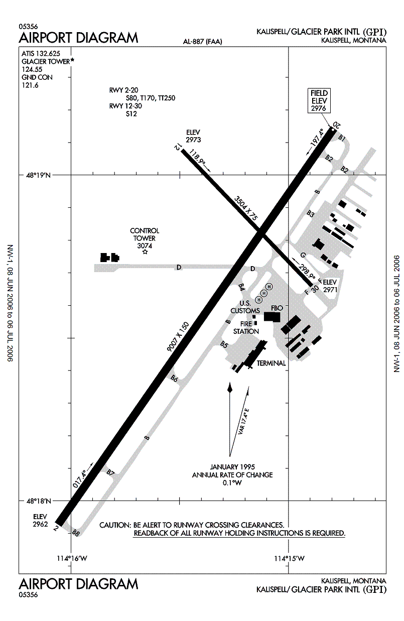
| FAA airport diagram |
| IATA: FCA – ICAO: KGPI – FAA LID: GPI |
| Summary |
| Airport type |
Public |
| Owner |
Flathead Municipal Airport Authority |
| Serves |
Kalispell, Montana |
| Elevation AMSL |
2,977 ft / 907 m |
| Coordinates |
48°18′38″N 114°15′22″W / 48.31056°N 114.25611°W / 48.31056; -114.25611 |
| Website |
www.GlacierAirport.com |
| Runways |
| Direction |
Length |
Surface |
| ft |
m |
| 2/20 |
9,006 |
2,745 |
Asphalt |
| 12/30 |
3,504 |
1,068 |
Asphalt |
| Statistics (2007) |
| Aircraft operations |
51,925 |
| Based aircraft |
159 |
| Source: Federal Aviation Administration |
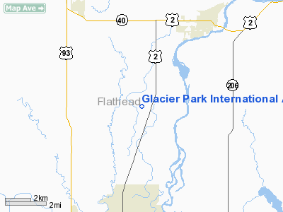
Glacier Park International Airport (IATA: FCA, ICAO: KGPI, FAA LID: GPI) is a public airport serving Flathead County, Montana in the United States. It located six miles (10 km) northeast of the central business district of Kalispell and also serves the towns of Evergreen, Columbia Falls, and Whitefish as well as Glacier National Park. The airport is owned and operated by the Flathead Municipal Airport Authority, an independent public agency created by Flathead County in 1974.
The airport's former ICAO code was KFCA, and most air carriers still use that code for reservations purposes. Although most U.S. airports use the same three-letter location identifier for the FAA and IATA, Glacier Park International Airport is assigned GPI by the FAA and FCA by the IATA (which assigned GPI to Guapi Airport in Guapi, Colombia). History
The airport was originally built in 1942 under the name Flathead County Airport. For many years, passenger traffic remained fairly low. In 1970, the airport was designated for international traffic and changed to the current name. Throughout the 1970s and 1980s, traffic picked up substantially, as Hughes Airwest, Western Airlines and Horizon Air offered flights. The terminal was upgraded in 1981, and further major upgrades to the terminal, runways and other facilities occurred throughout the 1990s. Between 1974 and 1998, the passenger traffic increased more than fivefold. [1] Service to Phoenix, Arizona on America West/US Air was suspended in 2007.
Facilities and aircraft
Glacier Park International Airport covers an area of 1,505 acres (609 ha) which contains two asphalt paved runways: 2/20 measuring 9,006 x 150 ft (2,745 x 46 m) and 12/30 measuring 3,504 x 75 ft (1,068 x 23 m).
For the 12-month period ending January 1, 2007, the airport had 51,925 aircraft operations, an average of 142 per day: 70% general aviation, 21% air taxi, 8% scheduled commercial and 1% military. At that time there were 159 aircraft based at this airport: 78% single-engine, 16% multi-engine and 3% jet and 3% helicopter.
Airlines and destinations
| Airlines |
Destinations |
| Allegiant Air |
Las Vegas |
| Delta Air Lines |
Minneapolis/St. Paul, Atlanta [seasonal] |
| Delta Connection operated by SkyWest Airlines |
Salt Lake City |
| Horizon Air |
Seattle/Tacoma |
| United Express operated by SkyWest Airlines |
Chicago-O'Hare [seasonal], Denver |
The above content comes from Wikipedia and is published under free licenses – click here to read more.
Location & QuickFacts
| FAA Information Effective: | 2008-09-25 |
| Airport Identifier: | GPI |
| Airport Status: | Operational |
| Longitude/Latitude: | 114-15-21.6000W/48-18-37.7000N
-114.256000/48.310472 (Estimated) |
| Elevation: | 2977 ft / 907.39 m (Surveyed) |
| Land: | 1505 acres |
| From nearest city: | 6 nautical miles NE of Kalispell, MT |
| Location: | Flathead County, MT |
| Magnetic Variation: | 18E (1990) |
Owner & Manager
| Ownership: | Publicly owned |
| Owner: | Flathead Muni Arpt Authority |
| Address: | 4170 Hwy 2
Kalispell, MT 59901 |
| Phone number: | 406-257-5994 |
| Manager: | Cindi Martin |
| Address: | 4170 Hwy 2
Kalispell, MT 59901 |
| Phone number: | 406-257-5994 |
Airport Operations and Facilities
| Airport Use: | Open to public |
| Wind indicator: | Yes |
| Segmented Circle: | Yes |
| Control Tower: | Yes |
| Lighting Schedule: | DUSK-DAWN
ACTVT HIRL RY 02/20, MIRL RY 12/30, MALSR RY 02, REIL RY 20, & PAPI RYS 02 & 20 - CTAF. |
| Beacon Color: | Clear-Green (lighted land airport) |
| Landing fee charge: | No |
| Sectional chart: | Great Falls |
| Region: | ANM - Northwest Mountain |
| Boundary ARTCC: | ZLC - Salt Lake City |
| Tie-in FSS: | GTF - Great Falls |
| FSS on Airport: | No |
| FSS Toll Free: | 1-800-WX-BRIEF |
| NOTAMs Facility: | FCA (NOTAM-d service avaliable) |
| Certification type/date: | I B S 05/1973
CLSD TO UNSKED ACR OPNS WITH MORE THAN 30 PSGR SEATS EXCP PPR CALL AMGR 406-257-5994. |
| Federal Agreements: | NGY3 |
Airport Communications
| CTAF: | 124.550 |
| Unicom: | 122.950 |
Airport Services
| Fuel available: | 100LLA |
| Airframe Repair: | MAJOR |
| Power Plant Repair: | MAJOR |
| Bottled Oxygen: | NONE |
| Bulk Oxygen: | NONE |
Runway Information
Runway 02/20
| Dimension: | 9007 x 150 ft / 2745.3 x 45.7 m |
| Surface: | ASPH, Good Condition |
| Surface Treatment: | Porous Friction Course
RY 02/20 SOUTH 1000 FT GRVD; BALANCE PFC. |
| Weight Limit: | Single wheel: 80000 lbs.
Dual wheel: 170000 lbs.
Dual tandem wheel: 250000 lbs. |
| Edge Lights: | High |
| |
Runway 02 |
Runway 20 |
| Longitude: | 114-16-03.5535W | 114-14-47.4588W |
| Latitude: | 48-17-55.6792N | 48-19-08.6236N |
| Elevation: | 2962.00 ft | 2976.00 ft |
| Alignment: | 34 | 127 |
| ILS Type: | ILS
| |
| Traffic Pattern: | Left | Left |
| Markings: | Precision instrument, Good Condition | Precision instrument, Good Condition |
| Crossing Height: | 50.00 ft | 47.00 ft |
| VASI: | 4-light PAPI on left side | 4-light PAPI on left side |
| Visual Glide Angle: | 3.00° | 3.00° |
| Approach lights: | MALSR | |
| Runway End Identifier: | | Yes |
|
Runway 12/30
| Dimension: | 3504 x 75 ft / 1068.0 x 22.9 m |
| Surface: | ASPH, Good Condition |
| Surface Treatment: | Porous Friction Course
RY 02/20 SOUTH 1000 FT GRVD; BALANCE PFC. |
| Weight Limit: | Single wheel: 12000 lbs. |
| Edge Lights: | Medium |
| |
Runway 12 |
Runway 30 |
| Longitude: | 114-15-29.3976W | 114-14-53.5533W |
| Latitude: | 48-19-04.6026N | 48-18-39.6311N |
| Elevation: | 2973.00 ft | 2970.00 ft |
| Alignment: | 127 | 127 |
| Traffic Pattern: | Left | Left |
| Markings: | Non-precision instrument, Good Condition | Non-precision instrument, Good Condition |
| Crossing Height: | 0.00 ft | 26.00 ft |
| VASI: | | 4-light PAPI on left side |
| Visual Glide Angle: | 0.00° | 3.00° |
| Obstruction: | 18 ft trees, 975.0 ft from runway, 43:1 slope to clear | 79 ft tree, 1100.0 ft from runway, 380 ft left of centerline, 11:1 slope to clear |
|
Radio Navigation Aids
| ID |
Type |
Name |
Ch |
Freq |
Var |
Dist |
| SAK | NDB | Smith Lake | | 515.00 | 18E | 14.7 nm |
| PLS | NDB | Polson | | 275.00 | 20E | 37.0 nm |
| LYI | NDB | Libby | | 414.00 | 17E | 49.5 nm |
| FCA | VOR/DME | Kalispell | 079X | 113.20 | 18E | 6.6 nm |
Images and information placed above are from
http://www.airport-data.com/airport/GPI/
We thank them for the data!
| General Info
|
| Country |
United States
|
| State |
MONTANA
|
| FAA ID |
GPI
|
| Latitude |
48-18-41.100N
|
| Longitude |
114-15-18.300W
|
| Elevation |
2977 feet
|
| Near City |
KALISPELL
|
We don't guarantee the information is fresh and accurate. The data may
be wrong or outdated.
For more up-to-date information please refer to other sources.
|
|